Southern California Hiking Bucket List: Mount San Gorgonio
- Oct 22, 2021
- 16 min read
Updated: 3 days ago
Quote for the Hike
'Getting to the top is optional. Getting down is mandatory.'
Mountaineer Ed Viesturs
Hike Details
Hike distance: 20.2 miles
Elevation gain: 3,687 ft
Prominence: 8,294 feet - ranks 7th among peaks in the contiguous US and 18th overall
TrailsNH Hiking Difficulty Calculator: 386 - Challenging

Why Hike San Gorgonio
For several years, Mount San Gorgonio had occupied a prominent place on my Southern California hiking bucket list. As the highest peak in the region, it represented both a physical challenge and an opportunity to experience a side of Southern California that contrasts sharply with the deserts below. Unlike many of my previous hikes, this adventure would require an overnight stay in the wilderness and a solo climb to the summit. More importantly, it was the final hike on a bucket list that began with San Jacinto Peak and Pinto Mountain, making it a fitting goal to pursue before leaving California for the season.
Preplanning for the Hike
There were a few problems trying to plan this hike.
Weather: The only reasonable time for me to hike San Gorgonio was during the early fall, since by winter the mountain is snow-covered and is not my preferred conditions for hiking.
I use mountain-forecast.com to track weather conditions since it provides the kind of details I need to find a 2-day window of acceptable weather (low winds and mild to moderate daily temperature swings). After searching for a week or so, I finally found my time slot. I’d start the hike midday on Thursday, October 21st, and complete it on the 22nd.

Solo Hiking: Dave made it clear he had no interest in camping overnight in the San Gorgonio Wilderness, but he understood my determination to complete this hike. Despite my reputation for seeking out ambitious adventures, he knows I take preparation seriously—whether it's a 3-mile stroll or a 20-mile trek and trusts my judgment.
Permits: Next, I needed to obtain an online permit to camp at the Fish Creek Saddle Campground and also a California Adventure Pass. An Adventure Pass is required if you are recreating in the Angeles, Cleveland, Los Padres, or San Bernardino National Forests of Southern California. A great fact: 80% percent of the revenue from the sale of the passes is reinvested in the local areas where they are purchased.


Then I laid everything out to pack.

Reliable Water Source: During the fall, I couldn't rely on Fish Creek as a water source, so I carried enough water for the entire hike—9 liters, or about 20 pounds. While I could have packed less and filtered water along the way, I had never depended on water treatment for drinking water and didn't think a solo hike was the place to start. Adding food, a tent, a sleeping bag, and other gear brought my total load to nearly 40 pounds across two packs. Here’s the photo Dave took before I loaded everything into the car and began the 2.5-hour drive to the trailhead.

Driving to the Trailhead: Reaching the trailhead was an adventure in itself. The final 7.5 miles followed a rough gravel road that included several challenging sections. Fortunately, I didn't encounter any oncoming vehicles, which would have made navigating the narrow road even more difficult. I would have stopped for a photo, but my full attention was focused on what the Forest Service generously calls a road.
Choosing the Fish Creek Route
I chose the Fish Creek Trail to reach the summit. Although it is longer than both the South Fork and Vivian Creek routes, it requires less elevation gain. Fish Creek also has a reputation as the road less traveled, and I often find solitude on the trail both relaxing and rewarding.
My plan for the hike was simple:
Day 1: Hike just over 5 miles from the trailhead to Fish Creek Saddle Campground, set up camp, and spend a quiet evening in the wilderness.
Day 2: Start early and hike the remaining 5+ miles to the summit. After returning to camp for a short rest and lunch, break down camp and complete the final 5-mile hike back to the trailhead.

Let's Start Hiking: Day 1
After the seemingly endless gravel road, it was a relief to reach the trailhead parking area. As a sign of what was to come, only one car was parked there, and a lone hiker was setting up a tent as I began my hike. The trailhead sits on the edge of the San Gorgonio Wilderness, meaning the hike offers a true wilderness experience from the very first step.

The trail started gently with the first half-mile descending to Fish Creek. It was a welcome start for today's 5-mile hike, which included over 1,800 feet of elevation gain.

In some sections along the trail, the forest resembles a vast tree graveyard with upright matchstick trunks and thick mats of crisscrossed fallen logs.

Where the Lake Fire Left Its Mark
Were the trees killed by drought and the invasion of bark beetle; destroyed by the Lake Fire (2015), felled as part of a fire perimeter control line; or cut down as part of post-fire cleanup? Whatever the cause, it was difficult seeing the impact up close.

The Lake Fire was first reported on June 17, 2015, but expanded rapidly on June 18, growing from about 1,500 acres in the afternoon to 10,000 acres in the evening. Hot, dry winds helped fuel the blaze in the densely wooded northern portion of the San Gorgonio Wilderness at elevations between 6,000 and 9,000 feet.

By June 26th, over 2,116 personnel were fighting the blaze. Finally, on July 15th, the Forest Service reported the fire was 98% under control. The remaining 2% proved incredibly difficult and time-consuming to extinguish. Due to extensive damage and necessary trail maintenance, some sections of the Wilderness remained closed until July 2017. Even today, charred debris is visible along the trail.

Ponderosa pines and firs are built to survive fire with thick bark that does not burn easily and protects the inside of the trunk. However, the Lake Fire burned with such intensity that huge tracts of these trees were destroyed.

There were a few water crossings, but the water was trickling through the creek bed.

A Trail Between Seasons
Soon Fish Creek Meadows came into view with grassy fields and tall pines and firs. The fall temperatures were creating a golden blanket of fall foliage.

After passing through the meadow, the trail began to climb. Although it was still a manageable grade despite carrying the 40-pound pack for 2+ miles. For the first time, I could see traces of last winter‘s snow on the trail.

With the increase in elevation came these beautiful mountain views.

The switchbacks steepened as they followed the southeast slope of Grinnell Mountain. I had initially thought about summiting Grinnell after setting up camp at Fish Creek Saddle, but the further I hiked, the less interested I became in adding more mileage and elevation to Day 1.

Staying Ahead of Dehydration
Throughout the day, I made a conscious effort to stay hydrated, taking frequent water breaks and chewing electrolyte candies. At more than 9,000 feet in elevation, just hours after being at sea level, I knew the combination of altitude, exertion, and dry mountain air could quickly lead to dehydration if I wasn't careful.
Here’s some useful information from drinkhydrate.com:
At higher elevations, your body works harder as your respiration rate goes up and your body loses water faster than it would at sea level. Your body is essentially working harder to inhale more oxygen. Therefore, the more energy your body exerts directly requires a greater water intake. According to the Wilderness Medical Society, “your body loses water through respiration at high altitudes twice as fast as it does at sea level”. Additionally, at high altitudes, there tend to be low humidity levels, which increases the body’s rate of evaporation of water.

Over 3 miles into the hike, and I had not run into a single person on the trail. What a feeling of solitude. For much of the hike, I was treated to outstanding views of the distinctive pyramidal summit of Ten Thousand Foot Ridge. The peak is one of just 21 named mountains in Southern California that rise above 10,000 feet outside the Sierra Nevada, making it a prominent landmark throughout the day.

Despite being tired, I still enjoyed these spectacular panoramic views. Mountains that stretched for miles then stopped abruptly at the edge of the Coachella Valley.
There had been an unintended benefit of hiking Gorgonio in the fall. The arc the sun traces in the sky is lower in the fall, which results in the mountains casting shadows earlier in the afternoon. I was able to avoid direct sun exposure even as the tree cover thinned.

The trail began to level off as I got within a mile of the campground.

A Quiet Night at High Creek Camp
With a mix of relief and accomplishment, I arrived at Fish Creek Saddle Campground around 4:35 p.m. It wasn't a fast ascent, averaging about 38 minutes per mile, but it was a steady, sustainable pace that I maintained throughout the afternoon. Missing from the photo is the second backpack I carried strapped to my chest, which made completing this section of the climb even more rewarding.

One of the surprises of the trip came when I arrived at High Creek Camp. When I secured my permit, the reservation system showed that several other campers had also reserved sites for that evening. Knowing others would be nearby provided a little reassurance, given the remote location and the fact that I was hiking solo. Since no one else had arrived, I had the pick of camp sites.

The next job was to make a pizza sandwich from slices I had brought from home. For some reason, the pizza tasted extra good that night.

As the early evening passed, no one else arrived. What I expected to be a shared campground turned into a solitary wilderness experience. Sitting alone in camp, surrounded by the forest and miles from the trailhead, brought a new appreciation for just how remote this part of the San Gorgonio Wilderness really is.

I was the lone camper enjoying the beautiful sunset with the blue and pink tones hovering over the San Bernardino Mountains.

As darkness settled over the mountains, a new question emerged: would I get any sleep? After spending some time admiring the spectacular night sky, I crawled into my tent around 7:30 p.m. Over the next fifteen minutes, my mind helpfully reminded me again and again that I was spending the night in a remote, high-elevation wilderness inhabited by black bears. By 7:45, I had probably considered that fact a hundred times.
Good night?

Let's Start Hiking: Day 2
If there was any doubt about being alone, it disappeared around 4:00 a.m. when the yelping of coyotes echoed through the darkness. It was a memorable reminder that the wilderness has its own alarm clock. Knowing there was little chance of falling back asleep, I got up, ate a simple breakfast of dry cereal and trail mix, organized my gear for the summit push, and relaxed around camp until heading back onto the trail at 7:30 a.m.

From the saddle, the trail traversed the northwest face of Lake Peak. The gentle incline was a great warm-up for the remaining 5 miles that stood between me and the summit. Speaking of the summit, San Gorgonio was faintly visible through the trees.

What an adrenaline rush seeing the summit lit by the morning sun. The first peak left of center is Jepson Peak, but my target was the flat summit of San Gorgonio, partially hidden by the tree trunk and located to the left of Jepson.

Goodbye Fish Creek, Hello Sky High
After less than a mile, I reached Mine Shaft Saddle and said goodbye to the Fish Creek Trail and hello to the Sky High Trail. The saddle sits at just under 10,000 feet.

Almost immediately, I was rewarded with spectacular views of the surprisingly close summit. This photo also captures part of the vast north cirque that stretches between San Gorgonio Mountain (the tallest peak, left of center) and Jepson Peak (the smaller bald summit just right of center). At 11,205 feet, Jepson Peak is the second-highest mountain in Southern California. However, with only 125 feet of prominence, it is not considered an independent peak and is largely overshadowed by its towering neighbor, San Gorgonio.
If you look closely, you can spot the Sky High Trail as a thin ribbon of snow traversing the northeast slope of San Gorgonio. It appears just left of center near the base of the mountain.

Much of the rock debris scattered along the trail is man-made. During the summers of 1965 and 1966, crews redesigned and relocated the Sky High Trail. Using shovels, crowbars, and dynamite, they removed multiple switchbacks and replaced them with a trail that traverses and curls around toward the south face of the mountain.

Looking up one of the many rock-filled chutes that descend the mountain. Over time, erosion, avalanches, and rockslides have created these extensive boulder fields.

Perfect Weather, Careful Planning
The weather was outstanding and exactly as predicted by mountain-forecast.com. Cool temperatures, very little wind, and clear skies made for a perfect hiking day. Caution continued to be the theme for today. I made sure to apply ample sunscreen, knowing most of the day would be spent with constant sun exposure. I was also carrying more water than I needed in case my hiking plans went astray; running out of water was not an option!

Around 10,400 feet, the trail enters the debris field of a historic aviation tragedy. Scattered among the rocks and trees are remnants of a C-47 military transport plane that crashed on the slopes of San Gorgonio Mountain on December 1, 1952. The aircraft was en route from Omaha, Nebraska, to March Air Force Base near Riverside when a severe snowstorm reduced visibility and forced it into the mountain. The impact scattered wreckage throughout the canyon, some of which remains visible today.
The tragedy did not end there. On December 5, 1952, a Marine helicopter attempting to reach the crash site also went down. Fortunately, the helicopter crew survived the accident.

The weather kept rescue crews away. When teams finally reached the site on Dec. 21, 1952, there was over 12 feet of snow that prevented them from finding any bodies. The C-47 crew wasn’t recovered until the following May.

When the trail was relocated in 1965 and 1966, the decision was made to leave the plane debris to serve as a memorial to the 13 men who lost their lives.
This was the second aircraft crash site I had encountered while hiking. The first was at the Quabbin Reservoir in central Massachusetts, where the crash resulted in no fatalities. This site felt very different. Knowing lives were lost here, I found myself struggling to balance documenting the experience with respecting the area as a memorial.
You can learn more about the Quabbin Reservoir crash site hike here.

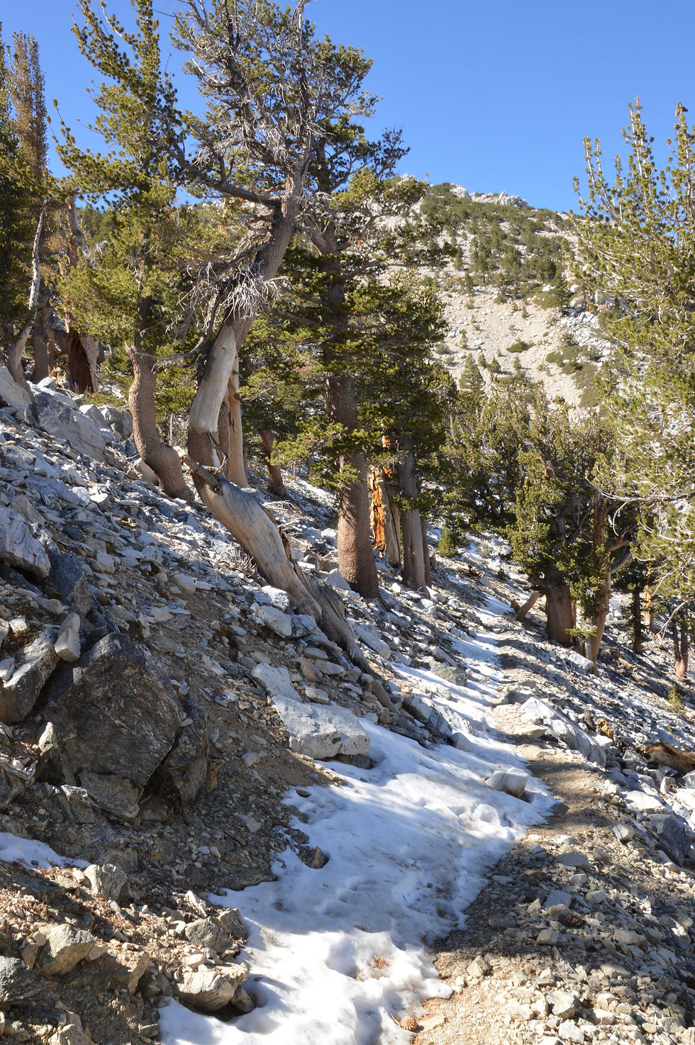
The higher I climbed, the more frequently snow and ice covered the trail. The slick surface, combined with loose sand along the edge, made footing uncertain and slowed my progress.
Walking the Sky High Trail, you can’t help but notice there are two very distinct views. The beautiful green tree-covered San Bernardino mountains and ...

... the barren, brown, tree-less San Bernardinos damaged by drought, beetle infestation, and wildfires.

The Dreaded Switchbacks
I approached the end of the traverse and knew that around the next turn were the dreaded switchbacks.

This 3D map, generated using FATMAP, shows the Sky High Trail and the series of switchbacks heading toward the summit.

The switchbacks began around 10,400 feet and climbed more than 600 feet in just three-quarters of a mile. Although short in distance, this section accounted for roughly one-third of the day's total elevation gain to the summit. By this point, the altitude was beginning to take a toll on my stamina, and my pace slowed noticeably. While these weren't the most challenging hiking conditions I had ever faced, there is no denying that the climb was extremely demanding and drained a tremendous amount of energy.
I took only one photo during this stretch, at the top of the switchbacks, so I could look back and appreciate how much ground I had covered.

After the switchbacks, the trail curved west and leveled out, gaining very little elevation. The relatively flat terrain was a welcome relief after the strenuous climb. Soon, the Tarn came into view, a barren basin tucked between two folds of the mountain. Each spring, snowmelt fills the Tarn, creating the highest lake in Southern California. By late summer and fall, however, the water is gone, leaving behind a dry landscape that looks more like a desert than a lakebed.
To the right is the craggy summit of Dragon's Head (10,866 feet), a rarely visited peak on the southern slopes of San Gorgonio. It ranks as the fourth-highest recognized summit in Southern California. Reaching Dragon's Head is not a hike to be taken lightly. The route follows a narrow ridgeline with dramatic drop-offs into a steep canyon on the east side.

I was also greeted by this spectacular view of San Jacinto rising 10,842 ft from the desert floor. It is the second-highest peak in Southern California, and along with San Gorgonio stands guard on each side of the mountain pass leading into the Coachella Valley. You can’t miss them driving into or out of the Valley.

After the switchbacks, the trail traversed the south face for over a half-mile, then swung to the west. It was frustrating that the trail was circling rather than zeroing in on my target.

The Mountain Sheds Its Forest
The low pines and gentle slope gave way to a barren landscape with a steady uphill climb. Harsh weather, thin soils, and thousands of years of freeze-thaw weathering had transformed the upper mountain into a stark landscape of rock, gravel, and scattered alpine vegetation.

The Last Leg of the Climb
Less than three hours after leaving camp, I reached the junction of the Sky High Trail and the San Bernardino Peak Divide Trail, better known as the Summit Trail. At 11,360 feet, this is where the Vivian Creek and Sky High routes merge for the final push to the summit. Under normal circumstances, this junction is a gathering point for hikers approaching from different directions. But on this day, the solitude continued. I had not seen another person since passing a lone hiker at the trailhead the previous afternoon.

From the junction, it was only 0.4 miles to the summit, which appeared ahead as a broad, rocky plateau. Unlike its dramatic neighbor, Mount San Jacinto, San Gorgonio lacks jagged spires and cliffs. From a distance, the highest peak in Southern California looked more like an enormous hill than a rugged mountain.

The final section of the trail was much rockier than I'd experienced elsewhere on the hike.

The Summit Was Mine Alone
Suddenly, I was standing atop San Gorgonio Mountain, the highest peak in Southern California at 11,503 feet. The hike from camp had taken just over three hours, averaging 36 minutes per mile. If nothing else, I was remarkably consistent with yesterday's pace of 38 minutes per mile.
The numbers, however, weren't what mattered most. Reaching the summit marked the completion of one of my Southern California bucket-list hikes and the culmination of months of planning and preparation. Standing alone on the highest point in Southern California, surrounded by sweeping mountain views and complete silence, made the accomplishment feel even more rewarding. It was time to celebrate, and I had the entire summit to myself.

Some hikers find San Gorgonio's summit a bit underwhelming. Covering nearly a square mile, the summit is a broad plateau of rock and gravel rather than a dramatic, jagged peak. But after the effort required to reach it and the experience of standing atop the highest point in Southern California, I couldn't disagree more. For me, the summit felt every bit as rewarding as the climb itself.

I quickly tracked down the summit marker.

After signing the summit register, I settled in to enjoy the views and reflect on the accomplishment. It was only 10:30 am and too early for lunch, so I made do with a few snacks while taking in the scenery. I spent about 30 minutes on the summit, still amazed that I had Southern California's highest peak entirely to myself.

Even with the haze, the views were outstanding. San Gorgonio hosts the longest recorded line of sight in the contiguous United States; it is plainly visible from the summit of Mount Whitney, 190 miles away.
To the north, the faint outline of Big Bear Lake.

To the south, the San Jacinto and the Santa Rosa Mountains rise above the haze.

To the east, the high desert plain and mountains of Joshua Tree National Park.

To the west stood Mount San Antonio, better known as Mount Baldy. At 10,066 feet, it is the highest peak in the San Gabriel Mountains, which form part of the boundary between Los Angeles and San Bernardino counties.

In the distance, I spotted another hiker making their way toward the summit. It felt like the right time to begin my descent. Despite being the most heavily visited wilderness area per acre in the United States, the San Gorgonio Wilderness had given me a rare gift: thirty minutes alone on the highest peak in Southern California. As I packed up, I hoped the approaching hiker would have the chance to enjoy that same sense of solitude and accomplishment.

The Summit Was Only Halfway Point on This Adventure
I shouldered my pack and began the hike back to Fish Creek Saddle. Although I had reached the summit, it was only 11:00 a.m. and many miles still lay ahead. As I started down the trail, I found myself thinking about Ed Viesturs' famous quote: 'Getting to the top is optional. Getting down is mandatory.' The summit may have been the goal, but the hike was far from over.
I decided to put the camera away for most of the descent and simply enjoy the scenery. During the return trip along the Sky High Trail, I finally began seeing other hikers, passing 10 to 15 people on their way to the summit.

I made it back to Fish Creek Saddle in less than 2.5 hours. Unfortunately, I arrived with a pounding headache, likely caused by a combination of altitude and dehydration. After taking a short break and a couple of Advil, I felt well enough to pack up my tent and the rest of my gear. It was strange to realize that it was only 1:30 p.m. By that point, I had already been moving for more than six hours and had covered 10.2 miles, yet the hike was still not over.

The last few miles to the trailhead were, without question, the hardest of the hike. The combination of fatigue, altitude, and miles already covered had taken its toll. Hiking solo added another layer of challenge. There was no partner to chat with or help break up the monotony of the long descent. It was just me, the trail, and the determination to keep moving forward. I took multiple breaks, worked my way through a lot of water, and focused on reaching the trailhead before darkness made the rough gravel road even more challenging to drive.

As I made my way back to the car, it struck me that this hike represented more than just another summit. With San Gorgonio complete, all three hikes on my original Southern California bucket list had now been checked off. What began as a simple idea several years earlier had turned into a series of unforgettable adventures across some of the region's most remarkable landscapes.

At 5:18 p.m., I officially completed the hike. My pace over the final stretch had slowed to 42 minutes per mile, but after covering 15.2 miles in the previous ten hours, that seemed perfectly reasonable. Back at the trailhead, I quickly traded hiking boots for clean clothes, splashed some water on my face, and took a moment to appreciate what I had accomplished before beginning the long drive home.
Closing Thoughts
Standing on the highest peak in Southern California was a fitting conclusion to my original hiking bucket list. From the granite slopes of San Jacinto to the remote terrain of Pinto Mountain and finally the alpine wilderness of San Gorgonio, each hike offered a unique challenge and perspective on Southern California's diverse landscapes. Completing San Gorgonio marked the successful completion of a goal that had been several years in the making.
While San Jacinto impressed me with its dramatic rise above the Coachella Valley, San Gorgonio felt wilder and more remote. The overnight stay at High Creek Camp, the quiet wilderness setting, and the long stretches of solitude created a very different experience from my earlier bucket-list hikes. Of the three adventures, San Gorgonio demanded the most preparation, planning, and self-reliance.
Completing the hike brought a strong sense of accomplishment, but what I remember most is the opportunity to spend a night in the wilderness, far removed from the lights and sounds of civilization. Few Americans will ever experience that kind of solitude. For me, the experience reinforced not only the value of setting ambitious goals but also how many remarkable places remain to be explored.

Continue the Adventure
Mount San Gorgonio was the final hike on my original Southern California bucket list. Read about the other two adventures:


I am always in awe of your challenging hikes. Just wow! Such an accomplishment!