Quartz, Palms, and Hidden Waterfalls: A Hike into Oswit Canyon
Updated: Jul 22
Why Hike Into Oswit Canyon
Oswit Canyon doesn't announce itself in typical bold Palm Springs fashion. There are no big trail signs or information kiosks. It's not a 'secret or 'off-the-grid' hike, but it does not draw as much attention as other well-known hiking trails in the valley. It simply begins in a wide sandy wash tucked between rugged foothills on the southern edge of the city. Oswit isn't the largest canyon in the Coachella Valley, but what makes it special is its ecological diversity, cacti, wildflowers, and desert fan palms all within a 2-mile hike from the trailhead; add a waterfall and incredible geology, and you've got the makings of a great short hike.
Hike Details
Location: Foothills of the San Jacinto Mountains
Trail Type: Out and Back
Distance: 4 miles
Elevation Gain: 974 feet
Difficulty: Moderate
Special Note: Based on the rock scrambling and trail-finding issues, you may want to consider this hike more difficult than the rating implies.
Terrain/Obstacles: Uneven terrain and occasional high step-ups. Rock scrambling but not technical. Water crossing on potentially slippery rock surfaces.
Hike Breakdown: Hike is suitable for novice hikers who want a challenge
Best Time: October - May
Highlights: Palm Springs hiking, desert fan palm oasis, seasonal waterfall, rock scrambling, San Jacinto foothills, quartz-rich geology, spring wildflowers.

TrailsNH Hiking Difficulty Calculator: 88 – Moderate
Click here to navigate to the TrailsNH website for a description of the hiking difficulty calculator.
Here is a satellite view of the trail we followed.

Let's Start Hiking in the Green Desert
The hike begins where the pavement ends. Clouds lingered around the snow-dusted San Jacinto Mountains after the previous day's storm. Ahead, the wash was surprisingly green, a clue that water moves differently through this landscape. Before long, we'd discover why this canyon supports such remarkable life.

The sandy wash at the trailhead is part of a much larger alluvial fan that spills out of the San Jacinto Mountains. It's a landscape built one storm at a time. Over thousands of years, flash floods have carried rock, gravel, and sediment from the mountains, depositing them in broad, overlapping layers that continue to reshape the valley today.

Mountain Effect: Water Flows Downhill
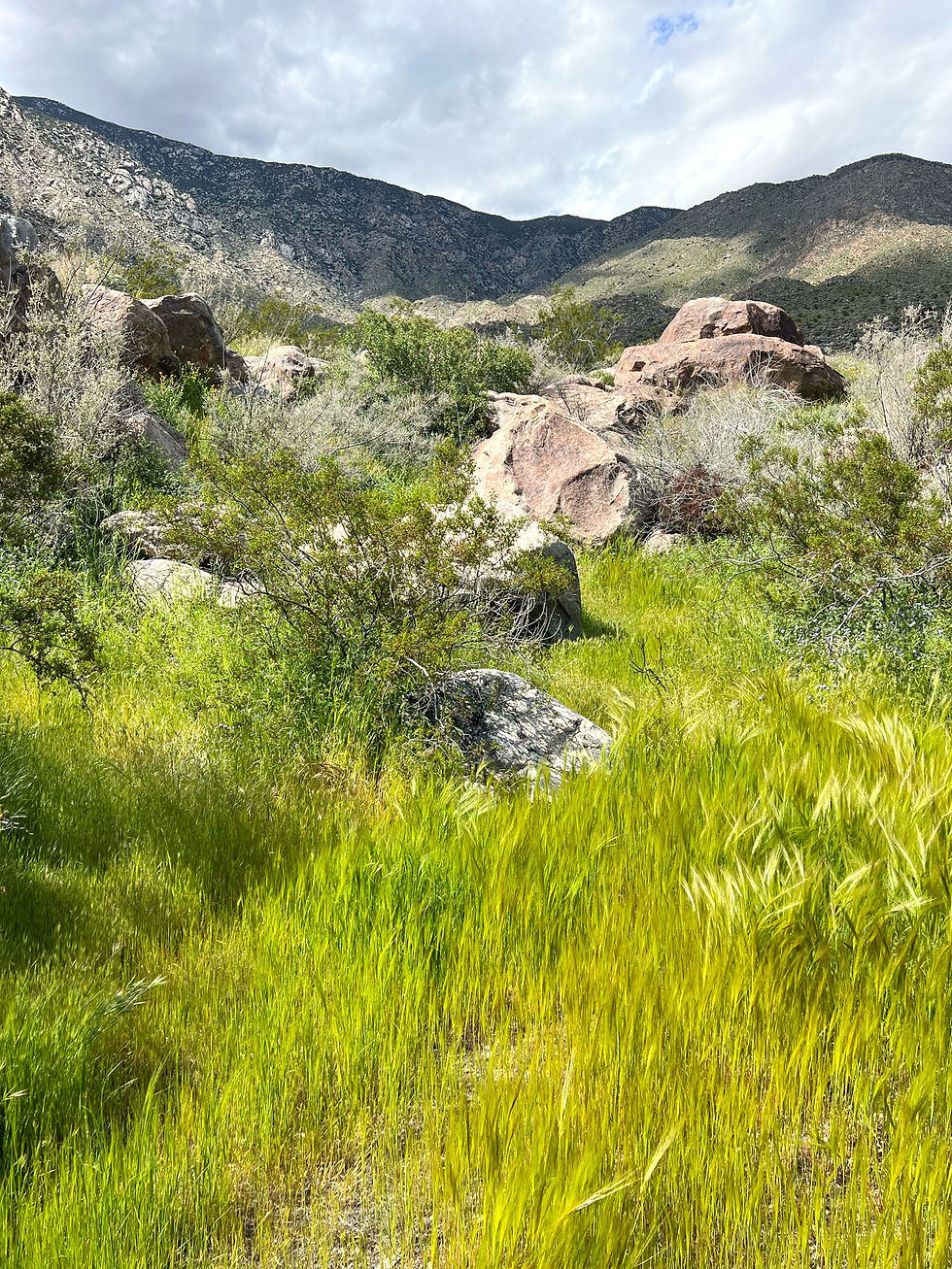
The one word I would use to describe the wash was green. In a desert, that's something worth noticing. Desert washes support far more plant life than the surrounding landscape because they collect the two things every plant needs most: water and nutrient-rich sediment.
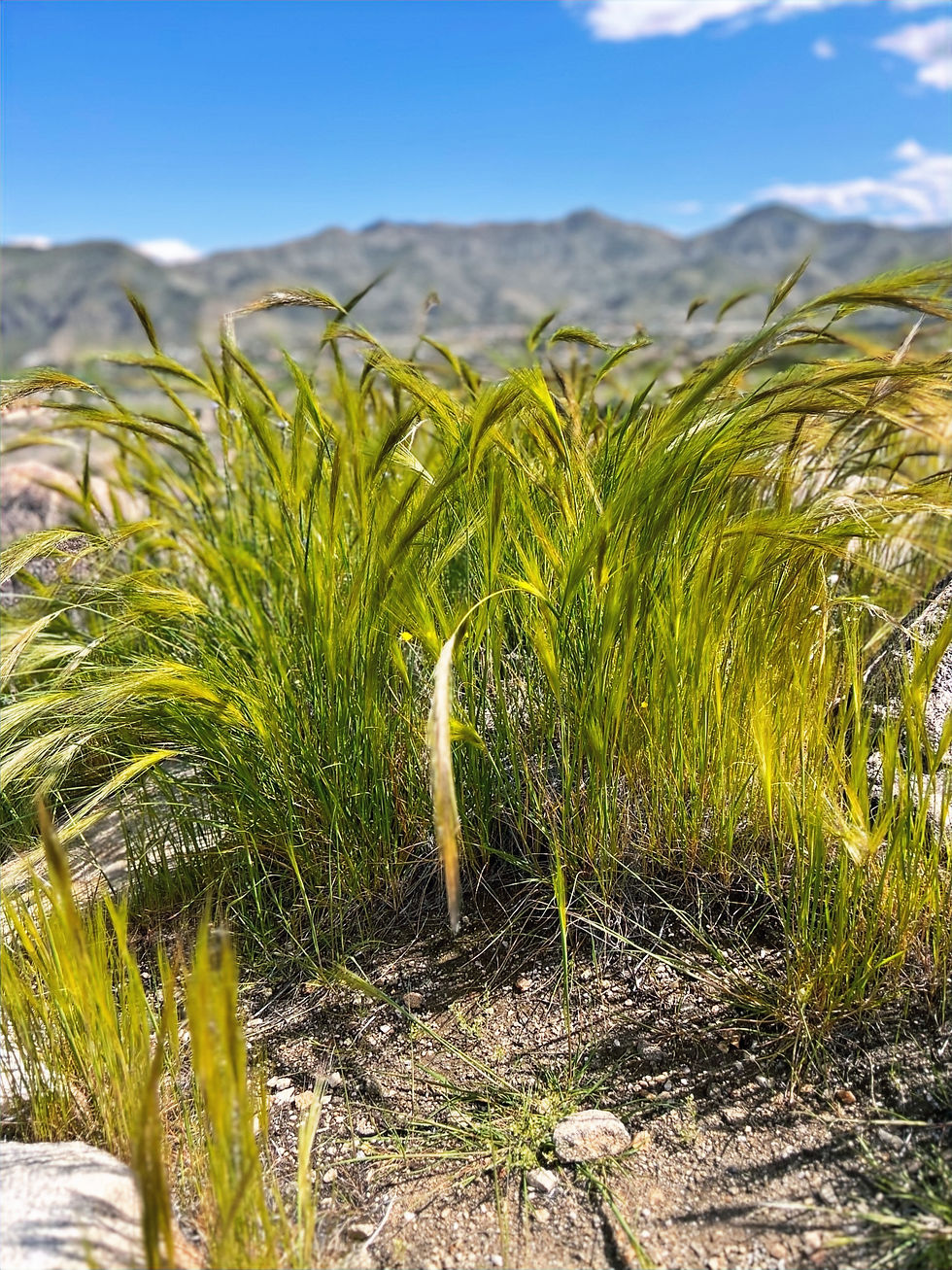
When Pacific storm systems are forced over the 10,000-foot San Jacinto Mountains, the rising air cools and condenses, producing significantly more precipitation at higher elevations. Although the Coachella Valley lies within a rain shadow, the Palm Springs foothills receive more annual rainfall than the desert communities farther east.
Steep canyons like Oswit funnel that mountain runoff into narrow channels, concentrating water that may have fallen miles away and thousands of feet higher. As the runoff rushes downhill, it carries nutrient-rich sand, gravel, and organic material eroded from the mountains before spreading it across the wash.

Together, the extra moisture and fertile sediments create ideal growing conditions for desert shrubs, cacti, wildflowers, and eventually the desert fan palms waiting farther up the canyon. What begins as rain in the mountains becomes the foundation for an incredibly green corridor.
Flashfloods Build Sandy Sponges
Every flash flood leaves behind another layer of sand, gravel, and silt carried down from the San Jacinto Mountains. Over tens of thousands of years, these repeated deposits have created deep, porous soils that act like giant sponges, soaking up water during storms and slowly releasing it long after the surface has dried.
The Desert's Water Hoarders
The moisture stored beneath the sandy wash nourishes plant life throughout the canyon and wash. Cacti have evolved their own way of surviving long dry periods by storing water inside thick stems, pads, or trunks. Instead of relying on frequent rainfall, they capture water during storms and slowly use it during periods of drought.
The bright yellow flowers of the California barrel cactus were impossible to miss, while nearby beavertail cacti had erupted into brilliant magenta blooms. Despite their different appearances, both survive by storing water during infrequent storms and drawing on those reserves through the long dry months.

Water Savers of the Desert
Spring rains transform the wash into a colorful display of wildflowers. Bluish/purple Canterbury bells brighten rocky slopes, while fiddlenecks and tiny annual cryptanthas spread across the sandy wash. Although these blooms appear delicate, each has evolved its own strategy for surviving the harsh desert environment.
Some, like Canterbury bells, take advantage of the brief window when moisture is abundant, growing and flowering quickly before the desert dries again. Others have evolved specialized adaptations to conserve every drop of water.

Many species, including fiddlenecks and annual cryptanthas, are covered with tiny hairs called trichomes. These delicate hairs reflect sunlight, reduce water loss by slowing evaporation, protect against drying winds, and even shield the plants from blowing sand. It's one more example of how desert plants have adapted to make the most of a landscape where water is always in short supply.

One shrub, chuparosa, stood out from the spring wildflowers. It produces brilliant red tubular flowers that bloom when hummingbirds are migrating through the desert.

Its nectar-rich blossoms provide an important food source, reminding us that the green wash supports not only plants, but an entire desert ecosystem.

Read the Landscape: Plants Reveal Hidden Water
You don't need to see groundwater to know it's there. The plants growing around you provide the clues. Cacti thrive where water arrives only occasionally, storing enough to survive months of drought. Spring wildflowers appear where winter rains have briefly recharged the sandy wash, completing their life cycle before the moisture disappears. Even the presence of lush shrubs like chuparosa hints that slightly more moisture is available than on the surrounding desert slopes.
Crossing Into Protected Lands
Around the one-mile mark, the canyon begins to change. The lush wash gradually gives way to towering granite walls, massive boulders, and exposed bedrock. The plants become fewer, while the rocks begin telling the story. Every boulder, cliff, and narrow passage is the result of millions of years of uplift, weathering, and powerful flash floods that continue shaping Oswit Canyon today.

Building Boulder Fields
Moving deeper into the canyon, the walls grow taller, and the trail winds through a landscape that is literally falling apart. Cracks formed over millions of years allow water to penetrate the granite. As temperatures change and roots expand those fractures, large blocks eventually break free from the canyon walls. Gravity sends them tumbling to the canyon floor, where they accumulate into the impressive boulder fields you'll scramble across today.

Beyond this point, the trail fades away. Instead of looking for a worn path, look for patterns in the rockfall. The spaces between the boulders often reveal the easiest and safest route through the canyon.

The scrambling begins gradually. At first, the route requires only a few easy step-overs and short detours around the fallen granite boulders before becoming more challenging farther up the canyon.

Read the Landscape
Which boulders fall next? Look up at the canyon wall. Can you spot the fractured blocks separated by wide cracks? Those fractures were created by movement along the San Jacinto Fault Zone that are widened by weathering. Daily heating and cooling, winter storms, and occasional freeze-thaw cycles slowly widen every fracture until gravity pulls the weakened blocks from the canyon wall. The next major rockfall will likely come from one of these already-detached blocks, adding another giant boulder to the canyon floor.

Notice how the largest boulders are clustered beneath the steep granite walls. That's no coincidence. These massive boulders are simply too large for flash floods to move very far. Instead, they accumulate where they fall, while smaller rocks and gravel are carried farther downstream. The farther you hike into the canyon, the more impressive the rockfalls become because you're getting closer to their source.

The chaotic landscape of massive granite blocks, fractured slabs, and angular debris isn't just scenery; it's evidence of a canyon that is still evolving. Every rockfall widens the canyon walls, causes the slopes to slowly retreat, and adds another giant boulder to the canyon floor.

Landscape in Motion
Rockfalls are a natural part of Oswit Canyon's evolution, not a sign of unusual instability.

The canyon walls you see today are only a moment in time. Every storm, rockfall, and season of weathering subtly reshapes the landscape, ensuring Oswit Canyon will continue to evolve long after our hike is over.

Sometimes, crawling under the rock piles is easier than climbing over them.

Ancient Plumbing
Millions of years ago, movement along the San Jacinto Fault Zone fractured the bedrock, creating pathways for hot, silica-rich fluids to flow through the rock. As the fluids cooled, quartz crystallized inside the cracks, sealing them with bright white veins, like those in this photo. Uplift and erosion later exposed this ancient plumbing system at the surface.

The quartz veins formed 1 to 6 miles beneath the Earth’s surface, long before Oswit Canyon existed. Today, they preserve a remarkable record of ancient geologic processes that once operated deep within the Earth’s crust.
Read the Landscape
Notice that the quartz veins vary in thickness, branch in different directions, and often intersect one another. Rather than a single crack, you're looking at a network of fractures that opened at different times and were repeatedly filled by hot, mineral-rich fluids. The rusty-red staining along some veins is iron oxide left behind as those fluids cooled.

The Palms Reveal Water
The first clue isn't the stream; it's the palms. In the desert, California fan palms don't grow by chance. Their presence tells you that groundwater is never far away. Listen carefully and you may hear the faint sound of water flowing beneath or across the bedrock, confirming what the palms already reveal.
High above the canyon, rain and snow falling on the San Jacinto Mountains seep into fractured bedrock created by the San Jacinto Fault Zone. As that groundwater slowly moves downslope, it eventually encounters less-permeable rock and is forced toward the surface, emerging as springs and seeps that sustain this oasis throughout the year.
The palms survive because their roots tap directly into this reliable groundwater supply. Unlike most desert plants, they cannot persist on rainfall alone. Once you recognize California fan palms as indicators of hidden groundwater, you'll begin seeing desert oases in an entirely new way.

The hidden groundwater soon reveals itself on the surface. A short distance upstream, crystal-clear water spills across smooth granite slabs, feeding a series of shallow pools.


The vivid green coating isn't moss; it's aquatic algae growing on submerged rock. Constant groundwater flow, abundant sunlight, and naturally dissolved minerals create ideal conditions for these algae, providing another clue that this water source is sustained year-round rather than being left behind by a recent storm.

The sound of flowing water had been hinting at what lay ahead. After a slight rise on the trail, the canyon revealed one of its best-kept secrets: a small cascade spilling over polished granite into a clear pool below. It's a reminder that some of the most memorable moments aren't the biggest or loudest, but the ones that reveal how the landscape works.

Why the Water Keeps Flowing
The waterfall begins with rain, summer monsoons, and spring snowmelt high in the San Jacinto Mountains. While some water rushes down the canyon as short-lived surface runoff, much of it seeps into fractured bedrock and slowly moves underground.
During wet periods, surface runoff briefly swells the cascade. As those flows diminish, groundwater becomes the primary source, allowing water to continue trickling over the granite while nearby desert washes have already dried.

The hanging grasses, algae, and California fan palms all tell the same story of a groundwater-fed oasis.

The fan palms provide a memorable ending to the hike and a reminder that some of the desert’s most remarkable places exist because geology, water, and time have worked together for thousands of years.

With plenty of photos, a quick selfie, and a well-earned snack behind us, it was time to head back to the trailhead.

On the hike back to the trailhead, we stopped for a short break and one last look across the canyon and …

… one last trip through the rockfall zone.

As we approached the trailhead, the clouds that had followed us most of the day were looking more ominous.

A Canyon That Teaches
Oswit Canyon is more than a scenic hike; it's a place that rewards curiosity. Every section of the trail reveals another piece of the story, from the green wash and granite boulder fields to ancient quartz veins and a groundwater-fed oasis. Once you begin recognizing how geology, water, and life are connected, you start seeing landscapes differently long after the hike is over.
Continue Exploring the Desert Fan Palm Oasis Series
New to California's desert fan palm oases? Learn how these remarkable ecosystems form, discover their unique ecology, and explore more of the state's finest oasis hikes in California Desert Fan Palm Oases: The Complete Guide.
Looking for your next adventure? Browse Best Desert Fan Palm Oasis Hikes in Southern California to compare the region's most spectacular oasis trails and find the one that's right for you.
Saving Oswit Canyon
Earlier in the hike, we crossed from land protected by the Oswit Land Trust into the Santa Rosa and San Jacinto Mountains National Monument. That boundary tells an important story.
In 2016, Oswit Canyon was slated for a large residential development. Plans called for hundreds of homes and flood-control infrastructure that would have transformed this natural alluvial fan into a suburban neighborhood, destroying habitat for desert wildlife and forever altering one of the last undeveloped canyons near Palm Springs. The aerial image below shows the proposed development near Palm Springs. Below is an aerial photo of the proposed development.
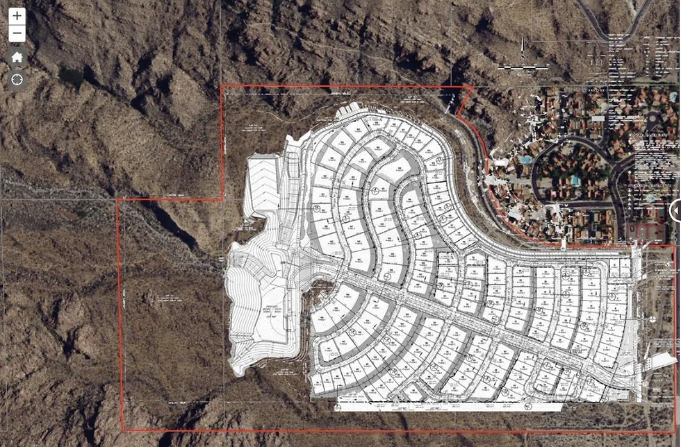
A grassroots organization called 'Save Oswit Canyon' formed in response. Over the next five years, residents, hikers, conservation groups, and public agencies worked together to protect the canyon. More than 5,000 people signed petitions, millions of dollars were raised through public donations and conservation grants, and in October 2020, 114 acres were permanently protected through a $7.15 million land acquisition.
Today, the property is managed by the Oswit Land Trust, ensuring that its wildlife habitat, fan palm oasis, unique geology, and public access are preserved for future generations. The image below shows the landscape as it remains today, a reminder of what community conservation can accomplish.

The next time you hike Oswit Canyon, remember that the palms, boulder fields, quartz veins, and flowing water aren't here by chance. They're here because a community chose to protect them.
240223


