Great Phoenix Day Trip: Driving the Apache Trail
- Jun 11, 2011
- 4 min read
Updated: Apr 21, 2025
So begins our first real vacation together outside of MA. We selected to travel to Arizonia since it provided access to so many exciting places and Dave had never visited the Southwest. I've broken the trip into 7 separate blogs. Click on the hyperlinks below to navigate to the selected blog.
1. Apache Trail
2. Sedona
3. Grand Canyon
5. Lake Powell
6. Route 66
7. Las Vegas

Since we started out in Phoenix, our first adventure was driving the Apache Trail. The Apache Trail, an old stagecoach road that runs right through the Superstition Mountains. In 1905, the trail was officially designated as an aid for the construction of the Theodore Roosevelt Dam, with Apache Junction at one end and Theodore Roosevelt Lake at the other end.

The Superstition Mountains are the largest of the mountain ranges surrounding Phoenix and hence are visible from many miles away. They rise steeply above the flat desert to a high point of 5,024 feet and are characterized by sheer-sided, jagged, volcanic peaks and ridges separated by boulder-filled canyons.


In the 1840s, the Peralta family of Mexico discovered gold near Apache Junction and continuously made trips to bring it back to Mexico. As the story goes, the family was ambushed by Apaches while on a gold expedition, leaving all but one or two family members left for dead. Decades later, Jacob Waltz, aka "the Dutchman," was said to have found the mine and hid gold in the Superstitions. When he died, he took the location of the mine to his grave.


Collin Hakes, Riley Morse, and Orlando and Orin Merrill were the first to discover gold in the Goldfield area of the Superstition Mountains. Soon thereafter, prospectors came to the area in search of gold. In 1893, the mining town, which became known as Goldfield, was founded next to the Superstition Mountain in what was then the Arizona Territory.


The town, in its heyday, reached a population of about 4000 residents. It had a hotel, general store, post office, church and school. The Goldfield Post Office was established in 1893. The Mammoth Mine produced about $3,000,000 in gold between 1892 and 1896.


When the mine vein faulted in 1897, the grade of ore dropped leaving the miners without a job. The town began to suffer since its economy depended heavily on the earnings of the miners who moved out.

It was not long before the rest of the towns residents relocated to other areas leaving Goldfield a ghost town. The Goldfield post office was discontinued in 1898.


Fortunately, the local bar and restaurant was open so we stopped by for lunch.

The ceiling in the bar is unique to say the least.

A few miles out of Goldfield, the trail begins to bend sharply as the land becomes steeper.


After driving for 15 miles we reached Canyon Lake, one of four reservoirs that were formed by the damming of the Salt River.


The last stop on the paved portion of the Apache Trail is Tortilla Flat. It is the last surviving stagecoach stop along the Apache Trail. According to the State, Tortilla Flat is Arizona's smallest official "community" with a U.S. Post Office, serving a population of 6.

We were greeted by this sign a few miles outside of Tortilla Flat. Now the fun begins.

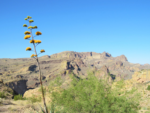
It was almost like as soon as the paving disappeared the amazing views and scenery began.


Our first close-up views of flowering agave and ocotillos.


The most interesting section of the trail was the mile long Fish Creek Hill that starts at the bottom of a granite mountain and...

curves right around the side of it…straight up. This section was definitely driven by me.

To these conditions, add a 10% grade, one lane and some blind curves and it's was a nail biters. Luckily we only drove by one car coming in the opposite direction. We both stopped, pulled in our side view mirror in and he slowly drove his truck pulling a boat by us. I think there was a rest area to stop and take it all in but we didn't bother to stop

These views more the made up for the nail-biting drive.


We reached the other side of the canyon and crossed the bridge over Fish Creek.

After what seemed like more than 22 miles on the unpaved roadway we reached the Theodore Roosevelt Dam.

The Roosevelt Dam was the first major project to be completed under the new federal reclamation program whose purpose was to design and construct irrigation projects to aid the settlement of the arid west. Started in 1906 and completed in 1911.
It was the largest masonry dam in the world for its time with a height of 280 feet and a length of 723 feet, while Roosevelt Lake was for a time the world's largest artificial reservoir. The dam was originally known as "Salt River Dam #1", it was not until 1959 that the dam and reservoir were officially named after Theodore Roosevelt.

In 1989, an ambitious expansion and renovation project was begun. The dam was resurfaced with concrete and its height was raised to 357 feet, thereby increasing the storage capacity of Roosevelt Lake by roughly 20%.

The bridge crossing Roosevelt Lake. It is currently the longest two-lane, single-span, steel-arch bridge in North America.

There was an amazing sunset as we drove back to Phoenix.

An overnight in Phoenix and then on to Sedona.