Araby Trail: Where Palm Springs Vistas Give Rise to Snow-Capped Peaks
- Feb 7, 2025
- 4 min read
Updated: Jan 1
Palm Springs is best known for its palms, putts and pools, but beyond the city streets lies a rugged desert shaped by the environment. The Araby Trail is a short but steep climb that reveals the plants that thrive in arid conditions, the geology of the Santa Rosa Mountains and sweeping views of the San Jacinto Mountains which were covered in snow during our hike.
Hike Distance: 5.6 miles
Elevation Gain: 1,550 feet
TrailsNH Hiking Difficulty Calculator: 132 – Moderately Strenuous

Click here to navigate to the TrailsNH website for a description of the hiking difficulty calculator

Let's Go Hiking
The Araby Trail wastes no time getting your heart rate up. From the start, it climbs steadily up a hillside through a series of switchbacks situated between a large mobile home park and a condo community that was built into the hill.


Lush Green Desert Expanse in Every Direction
It doesn't take long before you put the developments behind you and the foothills of the Santa Rosa take center stage.


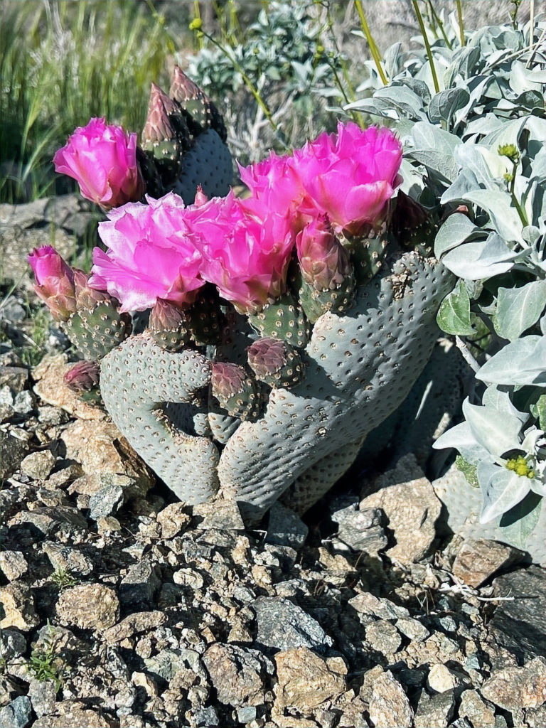
This beavertail cactus had just started to bloom. Named for its beaver-tail-shaped, blue-green pads it produces showy, vibrant magenta-pink flowers that attract pollinators like honeybees. After pollination, the flowers develop into sweet fruits that are a food source for desert wildlife.
Instead of large spines, the pads are covered in clusters of tiny, barbed bristles called glochids. These glochids can cause irritation if they get stuck in skin, requiring tweezers to remove. Most hikers will tell you they would rather fall into a barrel cactus than a beavertail cactus. The reason being, a fall into a barrel cactus is violent, immediately painful, and obvious event. A run-in with a beavertail cactus is more like an invisible, torturous attack, leaving you with a widespread, prolonged, and frustrating problem of microscopic, barbed splinters that are nearly impossible to completely remove.

There was one last house we had to pass, Bob Hope's famous 'volcano house'. The house was built to resemble a volcano with a massive undulating copper roof. Completed in 1979 and measuring over 23,000 sq ft. The house was primarily used for entertaining rather than as Hope's main residence.

Located on a 6-acre plot, the house sits approximately 200 feet above the desert floor. In 2016, the home was sold for $13 million.

Still more hills to climb. Each bend reveals a new view across the Coachella Valley and the foothills of the Santa Rosa Mountains.

Palm Springs Vistas with Snow Covered Peaks
When we crested the first series of foothills, we were met with a snow-covered view of the San Jacinto Mountains.

The trail had become a series of rolling hills.

Perfect spot for a selfie.

A glance eastward revealed the bare slopes of the Santa Rosa Mountains, in stark contrast to the snowy peaks visible to the west. One reason for this contrasting view is that the San Jacinto Mountains are the first barrier that moist Pacific air masses encounter as they move inland. When storms roll in, the air is forces upwards, cools and drops precipitation along the San Jacinto Mountains. The mountains literally queeze snow and rain out of storms leaving most of the Santa Rosas Mountains dry and snowless.

A solitary flowering beavertail cactus stood out like a beacon against the rocky terrain.
Around the 2-mile mark, we reached the switch backed side of a hill.

The sides of trail were covered in California poppies and lupine.

From the top of the hill, we were treated to remarkable views that also included the snowy San Gorgonio Mountains, just visible in the upper right corner. We could also see the trail leading to Cahuilla Peak, a small hill that rises 1522 feet above the desert floor,

The trail to the peak was a brief half-mile stretch.

A large cairn marked the summit.

After a brief lunch break, we continued on. Even after reaching the trail's highest elevation, we still had more over a mile left on the lollipop section of the trail.

We had excellent views lPalm Springs nestled against the San Jacinto Mountains.

Our next waypoint was the hill left of center.

The mountains views kept getting better.

Palm Springs Vistas with Dry Summits of the Santa Rosa Mountains
Without the mountain view’s, your eyes focus more of the plant life along the trail. This 12-inch tall gander cholla is well adapted to the harsh desert climate, with its segmented stems covered in dense spines that both deter herbivores and provide some shade to reduce water loss. You can see spring flower buds beginning to form on the tips. In spring, ganders produce a magenta to reddish-purple flowers that later in the season develop into yellowish fruit covered in burr or spines.

These two small California barrel cacti are battling for survival. Although they will not merge, one is likely to outcompete the other through a process called root competition. Barrel cacti have wide, shallow root systems that spread out just below the surface to absorb as much rainfall as possible. When planted too close, their roots will invade each other's territory and compete intensely for water and nutrients.Only one will likely survive.

Green healthy brittle bush lined the hills. For these ultimate desert adapters, leaf color is one sign of general plant health and as such it seems we have health plants along the entire trail.

Silver-gray leaves: Healthy adapted plant. The dense hair covering the leaves give them the gray look which is normal and a sign of stress.
Green leaves: Often appear after rains when the plant can afford to expend energy on photosynthesis. It temporarily reduces hair density on the leaves.
Yellow or browning leaves: Can signal drought stress, nutrient deficiency or natural seasonal leaf drop. During droughts, this is often a normal strategy rather than response to a disease.
Leafless plant: Not necessarily dead. Brittlebush can drop all leaves during prolonged drought, survive on stored energy until favorable conditions return.
On the return hike, we had excellent views of Murray Hill, the pyramid-shaped peak positioned slightly to the right of center.

Approximately two hours after departing from Cahuilla Peak, we arrived back at the switchbacks which mark the beginning of the hike. After completing this hike, I'd say the Araby Trail might provide one of the finest unobstructed, long-range views of the snow-covered San Jacinto Mountains.

240220


I like the balance and clarity of your piece. Seeing how technology is developing online entertainment platforms is intriguing. Those interested in learning more should website for further details. The essay provides a great overview of the current developments affecting interactive digital services.