Glacier National Park: Grinnell Glacier Hike Lives Up to It’s Legendary Status
- Sep 15, 2018
- 5 min read
Updated: Mar 22
About Glacier National Park
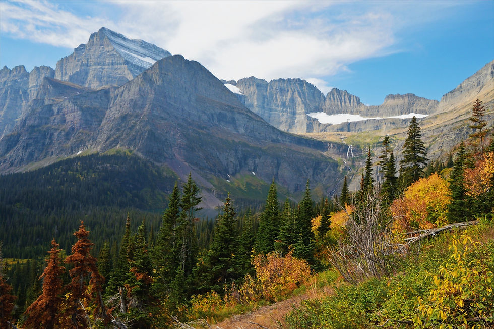
Glacier National Park (GNP) is called the ‘crown of the continent’ for a reason. GNP is impossibly scenic, with every turn in the trail providing an amazing view of mountains, jagged peaks, waterfalls, glacier-carved valleys, lakes, wildlife, and, of course, glaciers. The 1.4 million acre park contains some of the most beautiful mountain scenery in the west. These are the views you will never forget! Of the estimated 150 glaciers which existed in the park during the mid-19th century, only 25 active glaciers remained by 2010. Scientists estimate that all the active glaciers may disappear by 2030 if current climate patterns persist.
Why Hike Grinnell Glacier
Few hikes in GNP capture the park's raw glacial character quite like the trek to Grinnell Glacier.It's a hike that combines scale, geology and constant visual rewards earning its reputation as one of the legendary and unforgettable experiences in the park. Grinnell Glacier Hike in the Many Glaciers area is heavily trafficked (relatively speaking) but worth every moment.
First off, why is it called Grinnell Glacier? George Bird Grinnell was an influential leader in Glacier National Park history who 'discovered' the glacier in 1885. Grinnell is best remembered for advocating for the creation of a national park. As a result of Grinnell's tireless efforts over a period of time lasting almost 25 years, his writings, his lobbying and pleading with Congress, President William Howard Taft signed a law in 1910 creating Glacier National Park.
Hike Distance: 10.3 miles
Elevation Gain: 2,073 feet
TrailsNH Hiking Difficulty Calculator: 207 – Very Strenuous

Click here to navigate to the TrailsNH website for a description of the hiking difficulty calculator
Let's Start Hiking

With morning mist clinging to the valley floor, the hike started along the shore of Lake Josephine, firmly placing us in active grizzly bear country. Jenny Lake is prime bear territory because it concentrates many of the things grizzlies need to survive, reliable food, water and cover, all within a relatively small area.

The trail followed the western shoreline, gradually increasing in elevation.

Early morning clouds hung over the valleys and lakes. Time to make some noise t to avoid surprising any bears. The combination of beauty and 'bear country elements' is exactly why extra awareness and bear spray is essential.

Finally the fog and clouds lifted to reveal the jagged summit of Mt. Gould left of center, while our glacier destination came into view in the upper right corner partially hidden by the tree branches.. and we saw Mt Gould, the spiky peak left of center.

The views grew more impressive with altitude, highlighting Mt. Gould's dramatic east face and Angel's Wing.

Here was a perfect spot for a water break and picture.

The 7,450-foot Angel Wing is easily recognized by its distinct, flat-shaped, wing-like appearance rising above the lake. While considered a minor peak in Glacier National Park, its unique, prominent location makes it stand out against surrounding ridges and pinnacles.

As we climbed higher, we found a perfect viewpoint for Grinnell Lake, where the melting glaciers deposit rock silt that turns the water a stunning, opaque turquoise.

We also had a clear view of the rocky ridge that is part of the Continental Divide. Simply put, the Continental Divide is a mountain ridge in western North America. This ridge runs north to south and separates the flow of water on the continent. On the eastern side of the divide all streams flow toward the Gulf of Mexico and the Atlantic Ocean. On the western side all water flows toward the Pacific Ocean.


Attribute - Right Photograph: Pfly, CC BY-SA 3.0 <https://creativecommons.org/licenses/by-sa/3.0>, via Wikimedia Commons
Cascading hundreds of feet down the western headwall of Upper Grinnell Lake, the delicate, glacier-fed streams of Grinnell Waterfalls cut a striking image against the rock.

Don't forget to turn around. The views of Grinnell Lake, Lake Josephine, and Lake Sherburne behind you are spectacular.

At times, the path would just cling to the side of the mountain.

The next four pictures, taken while heading down, show the terrain changing as the trail hugged the sidewall."


We crossed a beautiful alpine meadow, brightened by a few lingering late-season flowers.

The thin outline of the trail is visible running across the center of the picture.

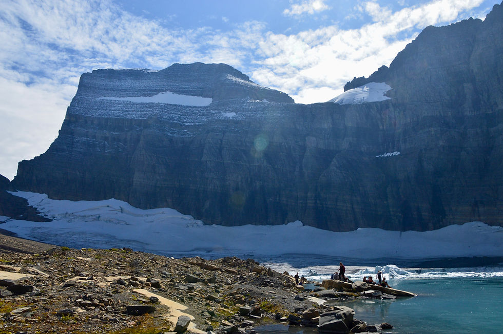
After climbing a series of steep switchbacks for 0.3 miles we reached the top. Both Grinnell Glacier in the bottom left and Salamander Glacier clinging to the rock face were visible. Salamander Glacier use to be connected to the Grinnell Glacier, but melting has caused the glaciers to separate.
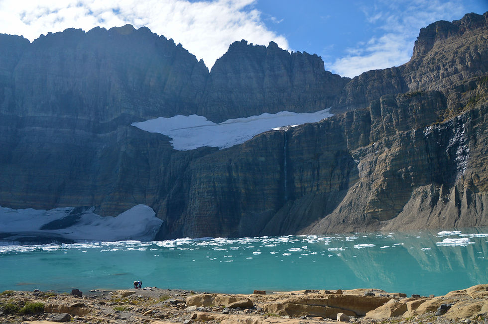
Geologically speaking this picture shows the black belt that runs through the mountains in this region. It's call the 'Diorite Sill'. This imposing layer of rock, unlike the lava, never reached the surface in a molten state, but was intruded between beds of sedimentary rock. Wherever it occurs it is bordered at top and bottom by thinner gray layers. These gray bands are Siyeh limestone, which was changed to marble by the tremendous heat of the diorite during its intrusion. This effect is termed 'contact metamorphism' by geologists because this zone of change occurs at both the top and bottom of the sill. If this banded layer had been formed by lava flows, then the gray-marble layer would only have occurred on the lower underlying rocks.

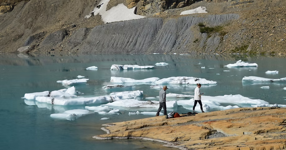
Done! Surprised by how incredibly large Upper Grinnell Lake looked. It was massive.

The deep, turquoise waters of Upper Grinnell Lake are created by glacier melt, offering a stunning backdrop to the two people walking on the shore.
Lighting was tough, but here’s my best attempt at capturing Grinnell Glacier by the rocky ridge. Situated above and to the right of Grinnell Glacier, Gem Glacier is GNP's smallest named glacier, covering less than 5 acres. As a hanging glacier, it drapes over the north face of a steep ridge. Between 1966 and 2005, Gem Glacier shrank by 30%, while the nearby Grinnell Glacier reduced by 40%.
How much of the glacier has been lost? Just compare these two pictures, on the left Grinnell Glacier in 1938 and on the right the glacier in 2005.


Attributes - Left Picture: T.J. Hileman (Glacier National Park Archives), Public domain, via Wikimedia Commons. Right Picture: Blase Reardon (USGS), Public domain, via Wikimedia Commons
After picking the perfect spot by the water, we sat down for lunch and soaked in the scenery.

The icebergs were magnificent when viewed from up close.

We watched two people dive into the freezing water; not quite that brave, we settled for just dipping in our hands and feet.


I feel like we could have stayed here for hours just taking it all in. We were lucky, the crowd was extremely light for a perfect hiking day.

Took a few more photos during lunch, but they fail to capture the sheer scale of the lake and glacier.

After lunch and soaking in the view, we began the hike back.


Still more incredible views on the return hike.

Returning to the shores of Lake Josephine and walking along the Swiftwater Lake.


What a perfect day and great hike in GNP. We planned a day of rest for tomorrow. Potentially our best hike in the park, Siyeh Pass, was next up. Click to navigate to the blog for Hike of Siyeh Pass
150918


This is just spectacular. What a hike. Those views are mesmerising. So sad to see how much the glaciers have retreated though.
This glacial trail is incredible!! I have never made it up near Glacier NP. I know I would absolutely enjoy myself there! I love that you had a picnic lunch and even dipped your feet into the lake!