Glacier National Park: Almost Lost on the Siyeh Pass
- Sep 17, 2018
- 5 min read
About Glacier National Park
Glacier National Park (GNP) is called the ‘crown of the continent’ for a reason. GNP is impossibly scenic, with every turn in the trail providing an amazing view of mountains, jagged peaks, waterfalls, glacier-carved valleys, lakes, wildlife, and, of course, glaciers. The 1.4 million acre park contains some of the most beautiful mountain scenery in the west. These are the views you will never forget! Of the estimated 150 glaciers which existed in the park during the mid-19th century, only 25 active glaciers remained by 2010. Scientists estimate that all the active glaciers may disappear by 2030 if current climate patterns persist.
Why Hike the Siyeh Pass Trail
Siyeh Pass Hike in the Saint Mary area was our premier hike for this trip to GNP. Although the distance hiked is basically the same as Grinnell Glacier hike, Siyeh Pass is a more difficult hike for the following reasons:
Maximum elevation is 8,100 (the highest in GNP) vs 6,600 feet for Grinnell
Elevation gain of 2,300 vs 1,600 feet for Grinnell, but the elevation gain is over a much shorter distance
Wind, snow, and temperature changes can be more extreme on Siyeh
More remote and less trafficked
Even the drive into the Saint Mary area of GNP provided epic views. The jagged mountain ridge slightly right of center is Little Chief Mountain which rises to an elevation of 9,456 feet.

Almost-a-Dog Mountain (8,922 ft) visible through a matchstick forest. This mountain is named for a Blackfoot warrior, Imazí-imita, who was a survivor of the 1870 Marias Massacre.

Hike Distance: 10.4 miles
Elevation Gain: 2,240 feet
TrailsNH Hiking Difficulty Calculator: 216 – Very Strenuous

Click here to navigate to the TrailsNH website for a description of the hiking difficulty calculator
Let's Start Hiking
Of course, we knew the Siyeh Pass hike started at the 'Piegan Pass' sign on Going-to-the-Sun Road. It was actually pretty cold when we started the hike at 8:30. You can't tell, but Dave had two layers of clothing under the jacket.


The trail started out with a gentle incline through dense forest bordered by the Siyeh Creek.


The dense forest offered only fleeting views of the surrounding mountains.

Entering Preston Park and Grizzly Country
As the forest thinned after a few miles, it was time to abandon whispers for noise—we were entering Preston Park and grizzly country, which meant bear bells, spray, and loud conversation. It warmed up a little, so we shed a layer.

A perfect, vibrant photo of autumn in GNP, blending striking striated mountains, blue skies, and rich fall colors.

With the forest cleared, our view opened up to Preston Park—a glacier-carved valley boasting meadows frequented by grizzly bears—while the cloud-draped, 9,215-foot peak of Reynolds Mountain loomed in the distance.

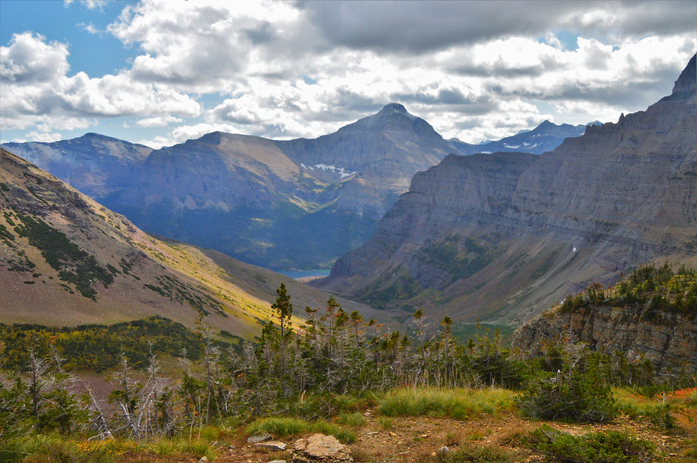
Gaining elevation above Preston Park offered a great vantage point of Piegan Mountain (9.220 ft) and the remarkably resilient Piegan Glacier. It’s fascinating to see it looks almost identical to 1930s photos, defying the receding trend of other glaciers in the park

Climbing to the Siyeh Pass
We took a brief break while ascending the steep switchbacks that led us up the rocky slopes of Matahpi Peak, with a 700-foot elevation gain. Here, we were exposed to the wind and cooler temperatures.

At 10,019 feet, Mt. Siyeh is one of only six peaks over 10k in GNP, looming directly over our route. This photo captures the sheer scale of its notorious North Face, even if the summit is out of frame. Rising 4,200 feet, this massive north face is one of North America's largest walls, towering directly over Cracker Lake.

A fully attributed view of Mount Siyeh since I missed getting a clear shot of the mountain.

Dave making final adjustment to his gear. The temperature was dropping, winds were getting stronger and we began feeling the effects of the 7,800 foot elevation. Over the course of the next nine-tenths of a mile we will climb almost 700 feet along a series of switchbacks.

Slow-paced, but still enjoying the scenery.

Situated behind Piegan Mountain is Pollack Mountain, which features a flat-top summit at 9,195 feet.

Oops, time to reverse course. We lost the trail due to deep snow, so we split up to look for it. I searched above the snowfield, and Dave searched below. The plan worked, and we were able to continue hiking. This was a proud moment for us because in the past with these weather conditions and this remote location, we would have turned back - but not this time!

Back on track with a little less snow on the trail.

The trail became significantly more narrow as it clung to the ledge. Drifting snow added another layer of challenge here.

Right around the corner, we reached the high point of the trail. Topping out at 8,100 feet, this is one the highest maintained trails in the park. Mount Siyeh and Siyeh Pass were named by George Bird Grinnell for a Blackfoot Indian by the name of 'Sai-yeh,' Grinnell was influential in establishing Glacier National Park in 1910.

After a short search for a wind-free spot, we finally settled in for lunch. Sitting here made those damn switchbacks worth every step. It was a lunch spot we won't soon forget.

Lunchtime view into Boulder Creek Valley

We packed up after lunch and began walking through the pass, enjoying great views of the jagged Point 8490 and the 8,831-foot pyramid of Goat Mountain to the right.

The trail rounded Mahatpi Peak as we began dropping into the valley.

Descending Toward the Valley
Going-to-the-Sun Mountain (9,647 feet) and Sexton Glacier soon came into view. The 68-acre glacier rests in a high-altitude cirque (approx. 8,000 feet) on the southeast slope of Matahpi Peak, immediately north of Going-to-the-Sun Mountain.

Vegetation quickly appeared along the path, providing views of a distant sliver of St. Mary Lake far below.
Fortunately, the path skirted this scree-covered slope.

Every turn on the trail revealed the same stunning, timeless view of Going-to-the-Sun Mountain and Sexton Glacier.

Late fall colors filled the valley, where we ran into only two other hikers. It was remarkable that for nearly 10+ miles, we had the trail to ourselves.

After a long, steep 2.5-mile drop of 1,450 feet from the pass, the terrain finally began to level out.

The downside, we were entering bear territory once more. Time to start making noise.

Walking through a match stick forest and burn area from the Reynolds Creek Fire of 2015

From our vantage point looking back, the view was dominated by Going-to-the-Sun on the left, the icy expanse of Sexton Glacier nestled near Mahatpi Peak, and the distant Siyeh Pass saddle on the far right.

Approaching the end, we passed through another "matchstick forest" featuring burnt trees and colorful ground cover.

The hike was spectacular—a true perfect day in GNP—and we finished in 5.5 hours. Following a short wait for the shuttle, we took some time to kick back and soak in the views before heading to the hotel.

170918


Enhance your wardrobe with versatile Yellowstone Clothing that blends comfort and timeless Western fashion. Complete the look with Yellowstone Dutton Ranch Merchandise, a must-have for true Yellowstone fans. Shop authentic styles and durable designs exclusively from Western Apparel.