We Heard Glacial Ice Groan on Cooper Spur: Mount Hood
- Jul 11, 2021
- 8 min read
Updated: Apr 21, 2025
There was no doubt that we'd hike on Mount Hood and the description of Cooper Spur, as one of the highest day hiker-accessible points on Mt. Hood, sealed the decision and Cooper Spur became our destination.
Hike distance: 6.5 miles
Elevation Gain: 2,995 ft elevation gain.
Highest Point: 8,860 ft
TrailsNH Hiking Difficulty Calculator: 197 – Strenuous

Click here to navigate to the TrailsNH website for a description of the hiking difficulty calculator
Starting the Climb

Could Cap Trailhead & Cooper Spur Hike on Mount Hood
This amazing hike started at the Cloud Cap Trailhead, which we accessed by traveling a 9-mile dirt road beginning just outside our hotel. By 8:00 am, we were at the trailhead and ready to go.

We followed Timberline Trail #600 through a forest of hemlock and fir before connecting with the Eliot Glacier Trail.

We watched as the trees quickly thinned out.

The trail became steeper and the hard packed surface was replaced with layers of soft volcanic ash and loose boulders.

Patches of dwarf lupine filled the fields with their purple blooms.

Within half a mile, we approached the tree line (elevation of 6,100 feet) and were greeted with krummholz of tangled and twisted whitebark pine roots and branches. These trees form fringe forests and woodlands at the timberline.

To the north, the distinctive flat top of Mount St Helens was visible through the haze. Below us were the burned out remains of the 2008 Gnarl Ridge fire that destroyed over 3,000 acres of trees on the mountain side.

In front of us was the spectacular north face of Mount Hood and Eliot Glacier pouring off the 11,250 feet summit. This is definitely a hike for people who need instant gratification; 15 minutes into the hike and these were our views.

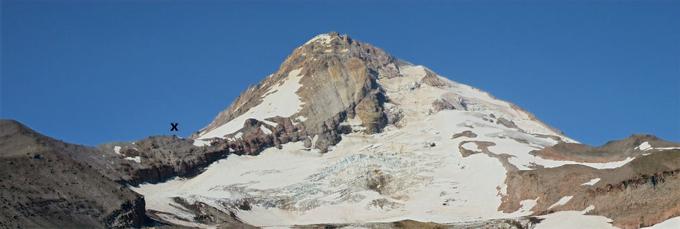
So you may be asking what is a mountain spur. A spur is a lateral ridge or tongue of land descending from a hill or mountain. They have lower ground in three directions and higher ground in one direction. In this photo taken from higher up on the trail, Cooper Spur is the rocky spine stretching down from the summit and the 'x’ denotes the end of the trail.
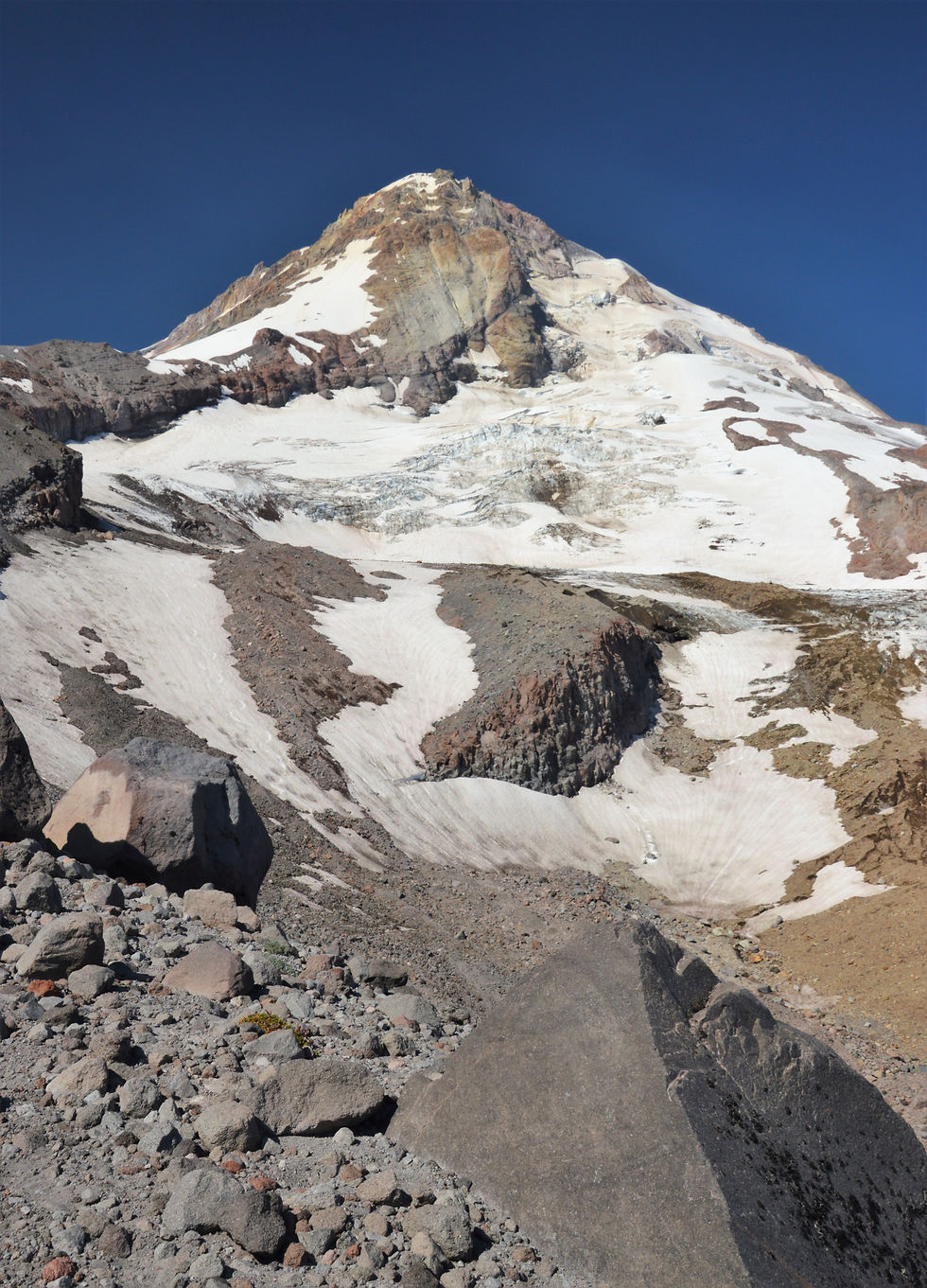
For as far as we could see, a narrow path followed the edge of the Eliot Glacier moraine. Think of a moraine as the collateral damage from a glacier. These sandpaper juggernauts of ice are so huge and powerful that they can break rock off mountainsides and collect large amounts of debris as they go. The moraine is the mess they leave behind -- the rock and sediment are deposited at the edges and in front of the ice flow.

Lateral moraines are sharp-crested piles of rocks and debris that form at the sides of ice flow. They typically are comprised of partly rounded and cleaved particles ranging in size from fine gravels to car-sized boulders. This unconsolidated mess resulted in loose footing which created problems when the trail narrowed to a few feet wide in spots.
Not surprisingly, these steeply sided walls are susceptible to failure. In November 2006, during heavy rainstorms part of the Eliot Glacier moraine failed causing debris to flow nearly 5 miles into the valley.

Several thousand years ago as Eliot Glacier flowed from the summit, it carved this deep, U-shaped trough that is now visible since the ice retreated. The trough created by this river of ice has classic steep side walls that curve inwards at the base and an almost flat valley floor. Melt water runoff from the glacier is channeled through narrow streams on the floor of the trough. These streams, barely visible discharge to the Eliot Creek.
In the distance, 58 miles away, is Mount Adams. Standing at 12,281 feet, Adams towers 9,800 feet over the surrounding countryside. It is the 2nd highest mountain in Washington and 3rd highest in the Cascade Range.

As we hiked on this beautiful cloudless day, it was difficult to take our eyes of the massive Eliot Glacier clinging to the north face. Eliot covers about 400 acres and is over 1.5 miles long.
A glacier toe or snout marks the end of a glacier. Many people incorrectly assume the lower rock-covered area is part of the ice-free landscape. However, in some places the lower glacier is covered by up to 6 feet of rock and rubble so its not possible to identify the glacier toe by just looking at the position of the ice. Although the toe looks peaceful and still, glaciers are in endless motion and the toe is always either advancing or retreating.

We've known for a while that the world's glaciers are melting. But a new study reveals they are melting even faster than previously thought, losing 31% more snow and ice per year than they did just 15 years earlier. Dr. Andrew Fountain of Portland State University summarized a recent international study on glacial melting:
"Glaciers have been shrinking really quite rapidly largely due to the warming sea surface temperatures and general climate warming in the Pacific and that includes those on Mount Hood where, in addition to warmer temperatures in the summer, warmer temperatures in the winter are leading to less snowfall. So the glaciers are less nourished in the winter and melt more in the summer and that ends up to be kind of a double whammy for these guys. I expect that by the end of the century, if climate projections are correct, Mount Hood will be nearly glacier-free."
Just how much has the Eliot Glacier retreated over the last century? These photos, courtesy of the Glacier RePhoto Database, provide clear evidence of the extensive melting.

Even as Eliot Glacier retreats, it remains the largest and most impressive of the 12 glaciers on Mt. Hood. This photo of Mt Hood's glaciers is provided courtesy of the USGS.

After following the edge of the moraine for over a mile, the trail began to veer away from the moraine up a large talus-covered hill.

The incline was definitely greater than 40%. The loose covering plus the 7,000+ elevation resulted in a slow but steady climb.

After reaching the crest, the trail began zigzagging through a series of switchbacks. We quickly gained elevation in this tundra terrain.

The high tundra is unforgiving but these patches of mountain wildflowers seemed to be thriving.

From time to time we lost sight of Eliot Glacier but never of the summit. The trail continued with relentlessly switchbacks up the steep shoulder of the spur.

We made a conscious decision to abandon the switchbacks about half way up and chose to follow a 'boot' trail that ran parallel to the Eliot Glacier moraine. We were extremely careful of the sensitive alpine ecosystem where damage caused by a stray boot print can last for years. Remember, 'leave no trace' as you hike.

We were forced to rejoin the original trail when footing on the boot trail became unstable and the terrain too steep. These final switchbacks wrapped around the south shoulder of the ridge overlooking the smooth ice of the Newton Clark Glacier rolling off the summit.

After 3 miles and 2,500+ feet of elevation gain, we approached the end of the Cooper Spur trail. The final half mile was mostly crumbling scree on a narrow ridge that connected the spur to the mountain; what a perfect ending for this hike. As a reference, the Cooper Spur trail ended at the flat portion of the ridge right below the summit glacier.

The path was not as level as it appeared. These mini switchbacks were necessary because of loose footing in the piles of volcanic ash and rubble.


This photo of the final pitch highlights the dramatic ridge and that feeling we had of walking 'close to the edge' that defined this entire hike.

Here is Dave passing the famous 'Tie in Rock' at 8,500 feet where the trail ends and the climbing route begins. Traditionally, climbers rope up here before continuing to the summit.

After Tie-in there were several small rock wind screens built by climbers. These shelters may not offer much protection but for climbers summiting Mt. Hood, they provide the last chance to take cover before the final ascent.

Success! Three hours after starting out at the trailhead we reached the end of the trail. The feeling of being so close to the summit without having to use crampons and an ice ax made this climb to 8,860 feet an incredible experience.

Time for a selfie by the glacier.

I couldn’t resist the urge to explore beyond the spur and headed to the Newton Clark Glacier. However, my adventure ended when we heard loud cracking and rumbling sounds coming from every direction. Using his best outdoor voice Dave asked/told me to return to higher ground.
There was something magical about hearing the sounds of the glacier groaning under the stress of its massive weight - ice cracking and rocks fracturing as the glacier shifted. It’s estimated the glacier moves between 6 and 22 feet each year depending on various weather conditions.

Time for a glacier nap after that harrowing experience.

It was a stunning lunch spot with jaw-dropping views. Despite the perfect weather, we were joined by only 5 other people at the top.


From our perch we could look down at the jumbled mass of crevasses on Eliot Glacier. The glacier is over 270 feet thick in places but during the last ice age it would have been more than 1,200 feet thick and would have flowed 9+ miles from the summit.

Here is a closer look at the crevasses that form as large masses of snow and ice move over uneven surfaces. The glacier's 'dirty' appearance is the result of avalanches that dislodge rocks and debris from the mountain’s weak headwall.

It wasn’t until I was building this blog that I realized one of our photos captured 3 climbers approaching a crevasse. I couldn't have asked for a better scenario; they add a perfect sense scale to the image.

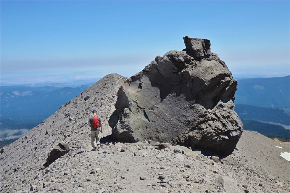
After 30 minutes, it was time to turn back. This huge rock on the trail was probably plucked off the mountain by a glacier. It was entrained in the ice and transported to this point where it was 'dropped' when the ice retreated. There is no other reasonable explanation for how a rock the size of a small house came to rest on the spur.
Some of the views heading back were simply amazing.

It’s easy to see why Cooper Spur is considered one of the best hikes in the Mount Hood Wilderness with vistas that rival any in the Cascades.

Back at the car 5.75 hours after starting out this morning. It wasn't a fast pace but we were not in a rush and really enjoyed today’s adventure.

Even the road to and from the trailhead was an experience. The 9-mile Cloud Cap Road climbs over 2,300 feet on the northern flank of the mountain and passes through a forest decimated by the 2008 Gnarl Ridge wildfire. The fire burned through 3,000 acres of trees including many already killed by mountain pine beetles resulting in a hillside covered with the remains of a once green and lush forest.

Without trees there were unobstructed views of Mt Adams. Even with an 18-mile wide diameter the behemoth Adams looks like it was floating on a layer of clouds.

I love how the AllTrails app provides 3-D maps. It's a great representation and highlights how the trail steadily climbs the spur.

Between the 3-D map and this elevation profile graph, you get a good picture of the long and slow climb...worth every moment.

There is no better way to end a spectacular hike that with an ice cold mojito. One more mountain day and then we head to the Columbia River Gorge .

How did Cooper Spur form?
I wondered how Cooper Spur formed and of course Google had the answer. About 30,000 years ago lava domes formed when viscous lava accumulated adjacent to a volcanic vent near the present summit. Fast forward to the Pollallie eruption period 15,000 years ago. The lava domes collapsed sending a massive pyroclastic flow and lahar down the north face of the mountain. Since ice covered much of the mountain, the flow was constrained between what is now the Newton Clark and Eliot glaciers. As these glaciers advanced and retreated, the volcanic deposits were chiseled into the large triangular ridge that we hiked on today.
Pyroclastic Flow: High speed avalanches of hot rock, gas and volcanic ash that are formed by the collapse of a lava dome or during a violent eruption. They can move up to 100 miles per hour and have temperatures up to 1,500°F.
Lahar: A wet mass of volcanic fragments including mud, rock, ash and glacial melt water flowing rapidly down the slope of the volcano.
Upper view of Cooper Spur

Lower view of Cooper Spur


Almost feels like the Jurassic age or something... those stratovolcanoes.. the raw wilderness.. this hike would certainly give anyone a good workout. Also, I learned a new Anglicised German word: krummholz (I had not been aware of the German word either). Glacier naps are the best naps!! Those three climbers really do give a good sense of proportion.
That really looks like a tough hike. I’d need some mojitos too after. Any hike with scree is generally an enemy of mine, I’ll always end up on my butt. We have a lot of glacially created landscapes here too, they are always fascinating. It’s hard to imagine the power of them.
Gorgeous views all around, but Mt. Adams summit floating above the cloud is my favorite. A beautiful day out!
2,995 feet is quite a summit. The views are well worth it though. I am intrigued by any place where you can wear a t-shirt while you walk around the snow...
What a great post. I feel as though I was on the hike with you. The views were well earned.