Hiking the 2nd Most Climbed Mountain: Mount Hood
- Jul 12, 2021
- 6 min read
Updated: Oct 16, 2025
We planned 2+ days at Mt Hood to provide a buffer in case we ran into bad weather and had to delay our Cooper Spur hike. However, we had perfect weather - so with no delays, we were able to squeeze in a few extra Mt Hood activities.
We made a brief stop at Trillium Lake, which offers a stunning backdrop with the snow-capped Mount Hood rising 7,600 feet above the alpine lake. Unfortunately, the breeze prevented us from capturing a perfect mirror reflection in the water, but it was still a beautiful spot.
Mt. Hood is a stratovolcano situated in northwest Oregon, approximately fifty miles east of Portland and thirty-five miles south of the Columbia River. Standing at 11,244 feet, it is the tallest point in Oregon and the fourth highest peak in the Cascade Range. The mountain began forming from volcanic eruptions between 700,000 and 500,000 years ago. Over the following millennia, additional eruptions continued to shape and elevate the mountain. At its peak, Mount Hood reached over 12,000 feet, but ice and erosion have reduced it to its current height.
Mt. Hood is the second most climbed mountain in the world, second only to Japan’s Mt. Fuji.

One of our side trips took us to the famous Timberline Lodge and we decided to add a short 5 mile hike to Zigzag Canyon Lookout at the last minute.
Built in 1937, Timberline Lodge is situated on the southern slope of Mt. Hood at an altitude of 6,000 feet. It ranks among Oregon’s top tourist destinations, attracting almost two million visitors annually. This impressive structure served as the exterior setting for the Overlook Hotel in Stanley Kubrick's film 'The Shining'.

The lodge houses an extensive collection of works by C.S. Price, whom the state historical society has described as "possibly Oregon's most significant and influential painter." He is also the uncle of one of our friends from California.

Looking at this photo, you wouldn't guess that our visit was in July. Timberline Ski Area is among the few ski facilities in North America that operate year-round, only closing for two weeks in September for maintenance. It was certainly unusual to see so many snowboarders and skiers carrying their gear to the lift.

On the lower mountain, the winter season generally spans from early to mid-November until Memorial Day. However, what truly distinguishes the Mt Hood Timberline ski area is its summer ski season. The Palmer Lift reaches 8,450 feet on the Palmer snowfield (indicated by the red arrow), enabling skiing to continue throughout the summer. The snow accumulation on this snowfield is so significant that the lift is entirely buried and remains non-operational during the winter months.

In a poor snow season, Mt. Hood can accumulate more than 21 feet of snow, while in a high snow season like 2015-2016, it can exceed 38 feet.

Unfortunately, skiing was not in our plans.

After enjoying our walk around the lodge, we headed out for a hike to Zigzag Canyon outlook.
Hike Distance: 4.4 miles
Elevation Gain: 885 feet
TrailsNH Hiking Difficulty Calculator: 88 – Moderate

Click here to navigate to the TrailsNH website for a description of the hiking difficulty calculator
Lets Start Hiking
The hike begins at the Timberline Lodge on a paved service road and then diverges onto a segment of the Pacific Crest Trail (PCT).

It's fun to think that during the winter we occasionally hike the PCT in the Whitewater Preserve (photo below) located in the San Gorgonio Wilderness area in Southern California. Same trail, same incredible beauty just 800 miles separating these sections of the PCT.

With clear skies, there are excellent views to the south of Mt. Jefferson. Standing at an elevation of 10,497 feet, Jefferson is the second tallest mountain in Oregon, following Mount Hood.

For about half a mile, the trail traverses the Mt Hood ski area following

a well-marked dirt path.

Dwarf mountain lupine lined the trail.

After a mile, we entered the Mt Hood Wilderness area. We stopped at the permit kiosk to obtain the free wilderness permit.

There was no shortage of mountain views along the trail.

We followed the trail to Little Zigzag Canyon, one of several canyons along the way to the outlook. We continued into the canyon where the Little Zigzag River drains meltwater from the Zigzag Glacier located near the summit. This canyon marks the halfway point.

While crossing the river, we noticed what appeared to be cougar tracks in the snow by the water's edge. The Office of Fish & Wildlife estimates that there are approximately 6,600 cougars in Oregon. They rank as the second largest cat in North America. Despite their size and widespread presence in the western U.S., these cats are seldom observed by people. In fact, they are solitary animals, spending most of their lives in solitude.

The trail led into a more forested area. Numerous trees were still down from the windstorm in September 2020, which caused widespread blowdowns across hundreds of acres.

Even with the state's efforts, the trail will require several years to repair because of the extensive damage and challenging terrain caused by thousands of fallen trees.

Some Cat's-ear lily were growing along the trail. These flowers are native to the western United States from northern California to Montana.


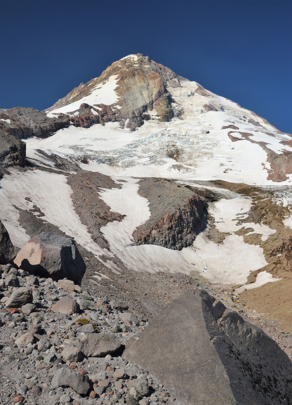
After hiking 2.3 miles, we reached Zigzag Canyon. Throughout the hike, we encountered several small canyons, but none matched the size of this enormous gouge in the mountain. Five hundred feet below, we could hear the Zigzag River flowing across the valley floor. It's difficult to envision when this river, once swollen with glacier meltwater, carved out this chasm. A faint trace of the river can be seen in the lower left quadrant of this photo.

The overlook was blanketed with beargrass. This typical wildflower, present in subalpine meadows of the Pacific Northwest, is neither a type of grass nor consumed by bears.
Beargrass can grow up to five feet in height with long and wiry, grass-like basal leaves at the base of the stalk and a cluster of small, dense white flowers at the top.


After taking in the canyon views, it was time to head back and make a few additional stops before departing the Mt Hood Wilderness Area.

Our final stop for the day was the pullout at the White River bridge along Highway 35. The river, which begins on the southeastern side of Mount Hood, flowed calmly through its rocky and gravel-filled bed.

However, looking at the extensive rock and sediment buildup on the nearly 900-foot wide river bed, it was obvious this stream had experienced dramatically higher water levels and devastating ‘debris flows’.

Debris flows are rapid combinations of loose sediment, rocks, organic material, and water that develop when the steep slopes of volcanoes or mountains become saturated and collapse. While small debris flows happen frequently without drawing attention, large debris flows triggered by storms cause significant destruction to anything in their way.
All the conditions necessary to trigger one of these devastating debris flow occurred in November 2006 on the south side of Mt Hood.
Intense Rainfall: Over a span of 6 days, Mt. Hood experienced over 13 inches of rain. Unusually high temperatures allowed the rain to reach the mountain's higher elevations, leading to enhanced glacial melting. The resulting meltwater, along with the heavy rainfall, saturated the steep sides of the glacial trough.
Exposed unconsolidated sediment: These two photos we captured along the Eliot Glacier show how the mountain is essentially a vast accumulation of loose and unstable glacial debris.


Steep Mountain Slopes and Glaciers: The south face of Mt Hood is marked with steep slopes and the Eliot Glacier clinging to the summit.
For more pictures like this click here for the blog: Hiking Cooper Spur on Mount Hood.
In the November storm, a portion of the Eliot Glacier moraine wall collapsed, causing a significant debris flow that surged over 5 miles down Eliot Creek into the valley. As it rushed down the mountainside, the flow scattered large and small debris throughout its path. Here are two photos of the White River bridge on Highway 35 following the debris flow (courtesy of the Oregon Dept. of Transportation).


The river looked quite peaceful during our visit. Calm for the time being.


38ft of snow is plenty, wow..!! Don't want to be hit by any of those massive boulders, though, when they are in motion. Mount Hood looks like a lot of fun as a holiday destination. I'd imagine I could spend a few happy days there.