Hike Swiss Canyon for Desert Canyons, Scrambles, and Big Views
- Mar 23, 2020
- 2 min read
Updated: Jan 4
Why Hike Swiss Canyon
Swiss Canyon is a great choice if you want a manageable desert hike with canyons, big views and a bit of a scramble.
Hike Distance: 4.2 miles
Elevation Gain: 1,108 feet
TrailsNH Hiking Difficulty Calculator: 97 – Moderate

Click here to navigate to the TrailsNH website for a description of the hiking difficulty calculator
Let's Start Hiking Swiss Canyon
For our inaugural hike in Desert Hot Springs, we chose the lesser-known route through Swiss Canyon, an off-the-beaten-path trail. Along the way, we noticed several signs directing to Brice Canyon, a common local name for the canyon and trail.

The trail, located in northeast Desert Hot Springs, covers a distance of 2.1 miles round trip and climbs over 475 feet in the first few miles. Beginning at an elevation of 1,326, it’s already higher than much of the surrounding Coachella Valley.

The trail starts in an open wash located in the foot hills of the Little San Bernardino mountains.


After a shot distance we enter Swiss or Brice Canyon.

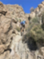
While not difficult or technical, small rock ledges climbs elevated the hike from mundane to more exciting.


After the short climb we entered a wash with tall canyon walls rising on either side of the trail.


These colorful gneiss and schist rocks were formed under intense heat and pressure when the North American and Pacific tectonic plates crashed and ground into each other along the San Andreas Fault system.

This area was a great environment for wild flowers including these tiny desert bluebells that were growing against the canyon wall.


There were also a few prickly pear cactus in bloom.

There were two additional climbs to reach the scenic lookout. The first was a 10-15 feet climb up a perpendicular fracture in a rock wall. With great hand holds it was an easy climb.


The second climb offered solid foot holds as well and ended at a narrow pinch point.
All that was left was to hike a scree-covered hill to the scenic overlook.

Our reward was an unobstructed view of Mt San Jacinto rising above the valley floor. Rising 10,834 feet, it’s the sixth highest peak in the lower 48 states. The 10,000-foot rise of the San Jacinto peak occurs over a distance of just 7 miles, making it one of the most dramatic and steepest elevation gains in the lower 48 states.

Another great hike in the Coachella Valley.