Oban and Mull Beautiful Sunsets Were Just the Beginning: Scotland
- Aug 13, 2019
- 6 min read
Updated: Apr 21, 2025
Locations/activities covered in the blog:
Oban
Isle of Kerrera
Tobermoray - Isle of Mull
Duart Castle - Isle of Mull
Day 7 Plans
On our first full day in Oban, we completed a hike of Buachaille Etive Mor in the Glencoe Valley of the Scottish Highlands. Click on the link above for the blog where we bagged our first Munro.
Day 8 Plans
After yesterdays tough hike, we designated today a chill morning. We enjoyed the usual breakfast of oatmeal and crumpets and then did a few loads of laundry.

The washing machines here are smaller and have more complicated cycles but Dave had mastered the situation pretty well. Without a drier we turned the entire apartment into a clothes line.
By lunchtime we were ready to explore Oban. We started with the stairs to McCaig’s Tower, which were located directly behind the apartment. This landmark, built on a hill overlooking the town, resembles the Colosseum of Rome. You can see McCaig's Tower in the top right corner of the picture below.

Built by John Stuart McCaig in 1987, his aim was to provide work for local stonemasons and to build a lasting monument to the his family. McCaig's Tower is a major attraction because of the magnificent views it provides of Oban, Kerrera, Mull, Lismore, and the Firth of Lorne. FYI: A firth in Scotland is a long estuary, the same as or similar to a fjord.

The Isle of Kerrera pictured below was our destination later in the afternoon.

Before heading to Kerrera via the ferry, we stopped at a pub for a cold beer.


Prior to the 19th century, Oban consisted of a few households, sustaining only minor fishing, trading, shipbuilding, and quarrying industries. The town sits in a near-perfect horseshoe shaped bay, protected by the island of Kerrera. During World War II the Royal Navy ships used Oban as an important base in the Battle of the Atlantic. It also played an important role during the Cold War. The first transatlantic telephone cable (1956) came ashore 3 miles south of Oban at Gallanach Bay. This line supported the 'Hot Line' between the US President and the leader of the USSR.
Since the 1950s the principal industry has been tourism, though the town is also an important port for ferries to many of the islands of the Inner and Outer Hebrides.


The sunsets speak for themselves.


Isle of Kerrera

Since the rain appeared to be holding off, we caught a small ferry to the Isle of Kerrera only 600 meters away. The island is approximately 4 miles long and about 1 1⁄4 miles wide. The Sound of Kerrera separated it from the mainland. We were warned that the last ferry back to Oban departed at 6pm and if we were late it would becomes an overnight adventure.
In the 2011, Kerrera had a population of 34. However in 2019, residents report the population has doubled to 68 people. From the looks of things in Ardantrive Bay, there are more boats than people on the island.

Although the island is best known for the ruined Gylen Castle (1582), we didn't have enough time before the last ferry and didn't want to rush so we skipped the castle and chose to enjoy a quiet walk around the north end of the island. We started out following a path toward the Hutcheson Monument (obelisk seen in the distance).
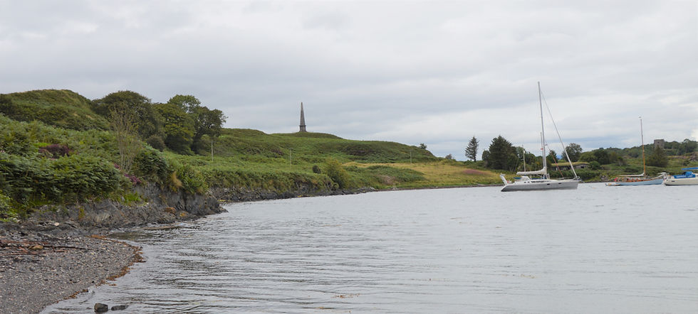
The 'path' was more an opening created by farm equipment cutting back the plant growth.

The trail became more narrow as we got closer to the monument. This stone obelisk overlooking the north entrance to Oban Bay is a memorial to David Hutcheson, who helped establish a regular steamer service to the Hebrides in 1835.

We had the hilltop to ourselves. Unlike being in Oban, we could sit back and appreciate the amazing views in silence.


We returned to the boatyard and walked in the opposite direction to the Ardantrive farm.

Along the way were fenced areas for the iconic Highland Cows also known as the Highland Coo.

Their unusual features enable them to survive harsh winters in tough environments. Their thick woolly undercoats keep them warm, while the longer guard hairs shed snow and rain. Long eyelashes and a thick fringe of hair protects their eyes from stinging hail, lashing rain, insects, and biting winds; they use their big horns to rake away snow in order to get to food.


Day 9 Plans
Tobermoray - Isle of Mull
Duart Castle - Isle of Mull
It was a misty and windy morning so it was the perfect time to take a ferry to the Isle of Mull. I wasn't taking any chances and used the Scopolamine Transdermal Patch (from home) to prevent motion sickness. However, it was a large ferry and the 45 minute ride from Oban to the pier at Craignure on Mull was relatively smooth.

After a few minutes we were cruising through the bay. Off to the right of the ship was Dunollie Castle. For a small castle, this place has a storied history with ties to the Irish Kingdom of Dál Riata (7th century); Norse Kingdom of the Isles (9th century); Kingdom of Norway (early 1200s), and finally Scotland in the 1250s. The existing castle ruins date to the 15th century.

In no time we were moving through the open waters of the Firth of Lorne.

Seeing the Lismore Lighthouse meant we were approaching Craignure. The whitecaps in the water were a sign that even through the voyage had been smooth the winds remained strong.

The Isle of Mull is the second largest of a group of islands that make up the Inner Hebrides, which meant getting around without a car would be challenging. Unfortunately, we couldn't bring the car over since all the car slots were taken when we bought our tickets. Once we disembarked, we figured we had two options for our time on Mull.
Option 1: Catch a bus from Craignure to the boat slip at Fionnphort on the west end of the Mull that ferries tourists to the Isle of Iona for a tour of Iona Abbey (founded in 563 by St Columba). However, the bus driver told us strong winds would most likely result in cancellation of these small ferries.
Option 2: Catch a bus from Craignure to Tobermory (45 minutes). Walk around the city, and then time permitting catch a private bus to Duart Castle.
Option 3: We could rent bikes and cycle around the coast in either directions, but the winds were still very strong. The thoughts of pedaling into the winds were not very appealing.
We chose option 2; see our trip plans on the map below. The island directly in front of Oban is Kerrera.

Tobermory is the largest town on Mull. The small quirky seaside town boasts everything you might need on your island trip – a colorful waterfront promenade, a handy supermarket, gorgeous views, cafes, pubs and restaurants.

We walked around the main street, browsed in some small cool stores, and then bought take away lunches so we could enjoy the sun. Afterwards we headed to the neighborhood in the hills above the harbor. In addition to these beautiful views, we stumbled onto an artist's studio. Dave and the owner discussed watercolor painting and he gave Dave a few pointers as well as one of his watercolor brush pens to take and try later.

We hustled back to the main street to catch the bus back to Craignure so that we could visit Duart Castle. This castle dates back to the 13th century and is the ancestral home of one of Scotland’s oldest clans, the MacLeans. The castle was well maintained until the 1600s when the MacLeans aligned themselves with the House of Stuart, a losing cause, leaving them poor and eventually landless.

For over 700 years, Duart Castle, with its huge curtain walls dominated the view to the Sound of Mull and Loch Linnhe. The position of Duart was well chosen; it was sited on a high crag at the end of a peninsula jutting into the Sound of Mull thereby controlled shipping and trade for the entire region.

Abandoned in 1751, it was eventually bought and restored in 1911 by Sir Fitzroy Donald MacLean, the 26th Chief of the Clan MacLean. Unfortunately, in 2012 the Chief of Clan Maclean announced that his family could no longer afford the upkeep of the castle in light of the expense of major repairs. In the winter of 2013–14 the castle lost four ceilings, which were brought down by water penetration through the chimneys. In July 2014, a restoration appeal was launched.

From the castle grounds you could see the Lismore Lighthouse and directly above the lighthouse was Buachaille Etive Mòr and Ben Nevis, the highest mountain (4,413 ft) in the British Isles.

Fortunately after the tour we got back to the pie early enough to enjoy a cold beer. Yes, I am the one who drinks the half pint.


We had a relaxing boat ride back to Oban. We had missed these views of the Highlands because of low cloud covering.

I captured a nice picture of Buachaille Etive Mor and Buachaille Etive Beag lit by the sun while the rest of the mountains remained in the shadows. Hiking to both peaks of this Munroe had been a great experience.


Wow, you covered a lot here! I've never thought of going to Kerrera before, that's very off the beaten path! :) The Isle Of Mull is probably my favourite place in Scotland so I'm really glad you made it there. How cute is Tobermory?!