James Bond and Hiking Great Bernera: Outer Hebrides
- Aug 21, 2019
- 5 min read
Updated: Apr 20, 2025
Hike distance: 8.1 miles
Recent History of Great Bernera
Great Bernera, often just known as Bernera, lies in Loch Roag on the northwest coast of Lewis. It is linked to Lewis by a single bridge built in 1953. Prior to 1953, Bernera could only be reached by boat.
Robin de La Lanne-Mirrlees, a descendant of King Louis Philippe I of France and godson of the 11th Duke of Argyll, acquired Great Berbera in 1962 without ever having laid eyes on it. The Count was a long-time friend of James Bond author Ian Fleming. The fictional James Bond character in Ian Fleming’s novel 'On His Majesty’s Secret Service' was modeled on Count Robin. Many speculate that his womanizing ways laid the foundation for Bond’s notorious romantic prowess.


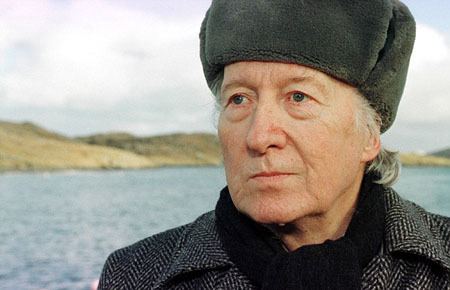
He moved to the island in the 1970s, falling in love with its isolation, rugged stunning scenery, and the warmth of the people. He was immensely well liked by the locals who referred to him as Count Robin. The French-born, Oxford-educated aristocrat died in 2012 at age 87 with the island passing to his grandson, Cyran de la Lanne. The family recently indicated that they were willing to sell to the island’s 252 inhabitants and in March 2015 the community voted overwhelmingly in favor of the buyout.
Great Bernera Loop
We weren't going to miss the chance to hike while we were on the Isle of Lewis and Harris. Weather be damned, we were hiking today no matter what conditions we had to face.
We chose the Great Bernera hike because it gave us the opportunity to hike close to home and also to hike along the coastline and among the many lochs in the area. Since most of our UK hiking was going to be in mountainous area, this change in scenery would be welcomed.
Definition: Loch is the Irish, Scottish Gaelic and Scots word for lake or sea inlet.
Scotland has over 31,000 freshwater lochs and the coastline is fringed with sea lochs.
To speak like a Scot, pronounce the "ch" as in "Bach".
After a short drive, we started the hike from the Breacleit Community Center parking lot. The trail followed a road for a short distance, but with beautiful scenery and no traffic we felt like we were already walking through the countryside.

The trail started off by following the shoreline of Loch Barabhat.

The road ended at a foot bridge that spans Tob Bhalasaigh.

This bridge technically crosses the Atlantic Ocean which depending on the tides, washes in or out of the Tob.

After crossing the bridge, we got first-hand exposure to Scotland’s 'right to roam', a 2003 law that allows people to responsibly enjoy Scottish lands and waters, no matter who owns them. For hikers, it’s a critical right in this country where 83% of land is privately owned vs 65% in the US. The trail literally followed the walkway up to this cottage.

We were respectful of their privacy and quickly and quietly walked by the house and rejoined the trail.

Heading up the path, we reached an abandoned home which added to the aura surrounding this hike.


The trail followed the coastline of Loch Roag whose waters are home to salmon, lobster, scallops, and mussels.


Beaches gave way to rocky ledges. Sea cliffs rose 50 feet above the water.


Fields were covered in flowering heather bushes.

The water of Camas (Gaelic for 'bay') Sanndaig was calm even though it been windy the entire morning.

The views looking inland were just as impressive.


After a mile of walking along the coast, the trail dropped down to the road on the outskirts of Tobson, the oldest settlement on Bernera.

After a short distance we were back on the coastal trail. Then like so many other days in Scotland, it began to rain. By now we had become experts at reading the clouds and had managed to don our rain pants and jacket just before the storm started.

The storm created rough seas. It looked nasty but the rain was fast moving and cleared quickly.

Leaving the coast path again, we began to climb Beinn an Toib. Although it's only an elevation gain of 205 feet, the views of Tob Bhalasaigh were impressive. In just under 2 hours we had walked the length of Tob Bhalasaigh from the narrow opening by the foot bridge to the head of the Tob by Beinn an Toib.

Fortunately, when we reached the top of Beinn an Toib the clouds parted and we were treated to a nice view of Loch Roag and the islands sprinkled throughout the bay.

The hills and mountains of the west coast of Lewis were visible despite the low cloud cover. Suaineabhal, the large round hill right of center, at 1,404 feet in elevation dominated the views.

Looking down the length of Loch Sgail. The trail became boggy as a result of the stream flowing from Sgail to the sea at Traigh (Gaelic for beach) Bostadh.

Entering the Bosta Glen, we passed the ruins of several blackhouses from a village that was abandoned in 1875. Only a small fraction of their stone foundations remain.

The trail continued to Traigh Bostadh and the Bostadh Iron Age house. The low-walled stone and turf covered building is a 1998 reconstruction of an iron age house based on findings from a 1996 excavation of a nearby site.
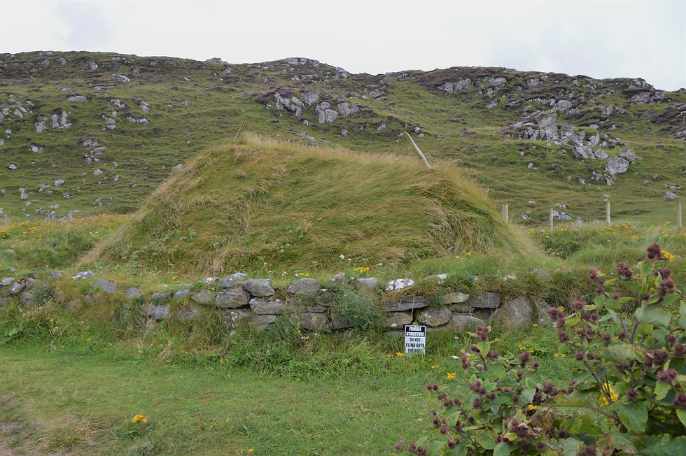
In 1993 a winter storm surge caused significant damage to the Bostadh dunes and beach but it also revealed evidence of stone structures. Archaeologists excavated the site in 1996 and discovered 8 well-preserved huts/houses all connected by tunnels. These houses, which date back to 500-700 AD, were part of a settlement that probably extended the length of the beach. Incredibly, many of the huts were virtually intact, having been preserved by the dune sands. After the excavation and investigation were completed, the huts were covered over with sand once more to preserve them. Unfortunately the replica hut was not open today.

We followed the path to Traigh Bostadh.

We had this secluded beach all to ourselves and stopped to enjoy the solitude. In fact we had not seen anyone during the entire hike.


Climbing up from the beach, we got our last glimpse of the Loch Roag islands as we headed inland.

The trail joined up with a single track road back to Breascleit - our starting point.

We followed the road for 2.5 miles back to Breascleit, while rain and wind was a constant for the remaining walk.

The countless stone walls carving up the grazing/farm lands were remarkable; they seemed to go on forever.


The 5-hour hike on Bernera was a great introduction to the coastal environment of the Hebrides. I'd definitely recommend it if you're visiting the area.


What a fantastic place for a hike. Love That little secluded beach great place for a stop off. interesting facts about the percentage of private lands.
What an interesting history and a beautiful location! So well done :)
I did not know that Bond was modeled after a real person! I'm not a huge fan of his "notorious romantic prowess" but the hike does look beautiful.