Rocky Mountain National Park: Summiting Hallett Peak
- Jul 14, 2019
- 9 min read
A Little Information About Rocky Mountain National Park
Hiking in Rocky Mountain National Park (RMNP) is like hiking into a vertical wilderness. In just a few miles, the trail climbs from ponderosa pine forests to wind-scoured alpine tundra where plants grow low, tight, and stubborn against nine months of winter. Nearly one-third of the park rises above tree-line offering a rare chance to hike through one of North America’s largest accessible alpine ecosystems without technical climbing skills.

Water shapes everything here. Glaciers carved the U-shaped valleys, gouged cirques beneath jagged summits, and left behind moraines that now cradle 140+ alpine lakes.
And then there’s the skyline. From the profile of Longs Peak to the sweeping views along Trail Ridge Road, this park offers unmatched landscapes. RMNP isn’t simply a place to hike. It’s a place to feel altitude, geology, weather, and wildness working together.

Given only four full days and a high probability of afternoon thunderstorms, we were hoping for favorable weather to squeeze in two solid hikes. Our first hike was to Chasm Lake and our second planned hike was Mount Ida.

Driving the Iconic Old Fall River Road
After hiking to Chasm Lake (Very Strenuous) on Day 1, we took a break on Day 2 and enjoyed an iconic drive through the heart of RMNP. Old Fall River Road, completed in 1920, was the first auto route in the park that provided access to the alpine tundra, which depending on exposure, starts at elevations between 11,000 to 11,500 feet. This road is a 9-mile long gravel and dirt, one-way uphill climb with plenty of switchbacks. Weather permitting it opens in early July.

The scenery right from the start was amazing.


One of the first pull offs was Chasm Falls. A short steep trail led to a nice view of the falls and the 30 foot drop.

After the falls, the road continued climbing into the subalpine region filled with spruce and fir trees. The trees began to shrink as the high-elevation climate becomes more extreme and plants become fewer.

Elk and mule deer are common in the meadows that mark the ascent to higher elevations.

Located above the tree-line, the alpine tundra of RMNP is considered by many as the most pristine in the lower 48 states. The growing season here lasts only 6-12 weeks. Most tundra plants are low growing and compact which shelters them against the drying cold winds. Despite the severe conditions, more than 100 species of flowering plants live on the alpine tundra.

On the roof of the Rockies where the road climbs to 12,183 feet, severe weather can come at any time. Temperatures commonly drop below freezing even in summer. Pictured below is Terra Tomah Mountain with its plateau top reaching 12,718 feet.

Trail Ridge Road views are not considered complete without a view of Mount Julian (left) and Cracktop Mountain (right). The 'crack' in the mountain is easily seen in this picture.

Driving Old Fall River Road was a fantastic way to experience the high-altitude, alpine tundra 'roof' of Rocky Mountain National Park.

Why Hike to Flattop Mountain and Hallett Peak
If you want a hike that delivers the full Rocky Mountain experience in one continuous climb, Flattop Mountain and Hallett Peak are hard to beat. What makes this hike special is its contrast: approachable yet alpine, steady yet dramatic. You gain serious elevation without technical climbing and feel the exposure of the high country without committing to a fourteen-thousand-foot marathon. It’s a hike that makes you feel like you earned your 'Rockies Hiking Badge'.
Hike Distance: 11.4 miles
Elevation Gain: 3,270 feet
TrailsNH Hiking Difficulty Calculator: 273 – Challenging

Click here to navigate to the TrailsNH website for a description of the hiking difficulty calculator
Let's Start Hiking
Originally, we had planned to climb Mount Ida but we were told the trail was snow covered and hikers reported postholing in large sections of the trail.

Due to these safety concerns, we decided to hike the combo trail to Flattop Mountain and Hallett Peak. The trail starts off along the shores of Bear Lake (elevation 9,453 feet) with this beautiful view of Hallett Peak, our destination for today.

This hike was a continuous series of taking shirts and jackets off then putting them back on again.

Forty minutes after starting the hike, the first layers were already coming off.

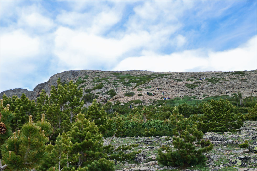
The closer we got to the tree-line the better our views were of the surrounding mountains.

Occasional breaks in the tree-line offered fleeting views of the mountain scenery.

It wasn't long before we could see the blocky shape of the Longs Peak summit across the valley.

We were approaching the upper limits of the subalpine habitat. In this environment, growth slows dramatically due to cold temperatures. Short, 6-12 week growing seasons result in stunted compact trees, a stark contrast to the tall spires at the start of the hike.

It is a high-elevation patchy mix of spruce and fir trees that serve as a transition separating the montane forests (8,000 to 9,000 feet) from the higher alpine tundra.

The thinning trees allowed for a spectacular view of Hallett Peak (red arrow) from this lookout. It looked so far away at this point.

As a rule, temperatures drop roughly 3-5°F per 1,000 feet. In addition to the impact of colder temperatures, wind stress at higher elevations favor compact forms since heavy snow load can snap tall branches and shallower thinner soils limit root depth. These trees aren't just smaller, they're built for harsher conditions.
Hiking in the Alpine Tundra
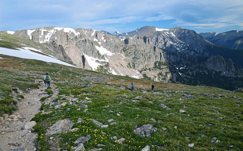
After a series of switchbacks, we crossed a climate threshold, the tree-line where trees disappear entirely (11,000-11,500 feet) . At this elevation, summer temperatures are too low for sustained vertical growth, roots can't establish in this nutrient poor alpine soils, and wind exposure becomes extreme. We arrived at the alpine tundra after covering 2.8+ miles and gaining close to 1,900 feet in elevation.

Above the tree-line the trail can feel like two different worlds. One slope is a shifting talus field of loose granite blocks. A few hundred yards away, the ground softens into grasses and tight mats of wildflowers hugging the earth. Why the contrast? It comes down to bedrock, ice, wind, water, and time.
Why Tundra Becomes Talus
A talus slope is an accumulation of loose angular rock fragments on a steep mountain face. This section on the trail certainly met that definition. By now, Dave had put a short-sleeve shirt over his long-sleeve top to stay warm against the cold wind blowing on the tundra.

Talus slopes form where:
Freeze–thaw cycles shatter bedrock into angular blocks. Water seeps into cracks, freezes, expands, and splits the rock. Over thousands of winters, the mountain shed rock debris that piles up on the slopes.

Steep gradients let gravity move broken rocks downhill. These rocky slopes are unstable, constantly moving and adjusting as more rocks are shed.

Plants struggle to establish themselves on unstable talus slopes because persistent winds remove the fine sediment needed for soil buildup.

Why Tundra Grows Green
Above the tree-line, even a change of a few degrees in slope angle can determine whether you’re stepping across shifting talus slopes or walking through an alpine meadow. It all comes down to whether the ground can hold on to crucial soil and sediment.
Vegetation thrives where:
When the slope angle decreases, soil and sediment have time to accumulate between rocks rather than gets washed or blown away. Over decades and centuries, a thin but stable soil layer forms. That thin soil is enough for specialized plants to take root.
Gentle slopes collect deeper snowpack which insulates plants from the cold and releases steady moisture during melt. Snow cover also protects roots from wind desiccation.

Plant stabilize the surface. Lichen and moss are foundational building blocks in this ecosystem. Over time, lichens colonize bare rocks. They secrete weak acids that chemically weather minerals which in turn traps dust and fine particles. Finally when lichen die they contribute organic matter to the building soil layers. Lichen don't need soil to begins but they help create it; they are the engineers of soil formation.

When sufficient soil has accumulated, plants thrive. Their root help knit the soil together. This creates a feedback loop: stability invites vegetation and vegetation increases stability. In the tundra environment, a single inch of soil can take centuries to form. However, that thin layer of soil is enough for grasses and wildflowers to germinate, root, and bloom.

Not only is the soil slow to develop but it's extremely fragile. When stepped on repeatedly: soil layers collapse and fine particles get blown away; shallow plant roots can be crushed; and water flow patterns can change resulting in significant plant stress or death. Cushion plants damaged by a single footprint may need years to regrow.

Hooker Mountains-Avens are a signature wildflower in the park. It is built for harsh conditions. It has leathery leaves to prevent desiccation and handle intense UV exposure at this elevation. It also hugs the ground, since survival favors staying low, where air temperatures may be a few degrees warmer.

This alternating pattern of talus field then grassy slope is the mountain negotiating with climate. One patch is being broken up and the other is slowly stitching itself back together.
Most of the hike in the alpine tundra was into a strong head wind. Up here the wind rarely rests. Flattop Mountain's broad summit, where we were headed, acts like a wind catching platform. Nearby cirques and valleys funnel air upward, concentrating gusts along the ridge and trail. It was time to add another layer and put on our jackets

Just below the summit of Flattop Mountain, we reached a horse hitch rack with great views of Hallett Peak and Tyndall Glacier (far right). Time for a picture without the jackets.

A snow field crossing led to the Flattop summit. It was much easier crossing this snowfield than the one we encountered on the hike to Chasm Lake. It was getting even colder as the wind whipped across the snow field.

A short distance after the snowfield, we reached the summit of Flattop Mountain. To reach this milestone, we had covered 4.4 miles and gained almost 2,800 vertical feet. The head winds, altitude, and cooler temperatures had slowed our climb from the tree line to the summit.
At the summit (12,324 feet) it's easy to see how this mountain got its name. It feels almost out of place, a wide tundra bench/table surrounded by spired summits. It's flat because its old rock (1.7 billion years old) that was uplifted but only partially sculpted by glaciers. The other pointy peaks were carved more aggressively, from more angles, and for longer periods of time.

The trail to the summit of Hallett Peak branches off from the Flattop Mountain trail and is mostly marked by rock cairns leading to the top. It's approximately 0.4 miles in length with 400 feet of elevation gain.

Along the way to the peak, we passed Tyndell Glacier and Gorge as two people were getting ready to strap on their skis for what would obviously be a great run.

It's a lot steeper than it appears in this photo.

To better show the steepness, here is a photo taken at a different location that captures Hallett Peak as well.

Leaving the tundra bench of Flattop Mountain, the final stretch to Hallett Peak feels longer than it looks. At this point, we'd already climbed nearly 3,000 vertical feet; our legs knew it and now our lungs definitely knew it. The final gain of 400+ feet is modest on paper but at 12,300 feet your body thinks otherwise. The air holds 35% less oxygen than at sea level. Your body has to work harder to oxygenate which can cause severe shortness of breath, increased heart rate, and potential altitude sickness (headache, nausea, fatigue). Slow and steady is the rule here.
Now add to these challenges, the requirement to climb a 15-20% talus slope. While cairns are present, you might want to choose your own best route to the summit.

We took a short break to catch our breath and admire the Flattop Mountain view.

Hikers on their way down as we were heading to the summit.

After reaching the Hallett Peak summit (12,713 feet), we celebrated our success.

Sheltered from the wind by a rocky outcropping, we paused to admire the breathtaking views and enjoy some snacks. With a forecast of potential rain in the late afternoon, we cut our visit short and headed down to avoid being in the open and exposed if inclement weather descended on us.

Joining us during the snack break was a pika. These small, round alpine mammals live in the talus fields scattered across RMNP. Closely related to rabbits, pikas don’t hibernate. Instead, they spend summer gathering mouthfuls of grasses and wildflowers, creating hay piles tucked between rocks to sustain them through long alpine winters. Pikas are highly sensitive to heat and rely on the cool air circulating beneath boulder piles to survive. That makes them important indicators of climate change in high-elevation ecosystems.

Our summit views.
The blocky summit of Longs Peak left of center.


Short video taken at the summit.
Our last look back at Hallett Peak and the long journey back to the car.

On the way back, we focused our attention on reaching specific milestones, starting with the snowfield.

Marmots exploring the meadows was a fun diversion from the windy tundra hike.

With great anticipation, we reached the tree-line and the subalpine forest.

Much later on, we reached the upper montane zone characterized by taller trees and a more dense forest.

But the best feeling of all was the view of Bear Lake and the trailhead. This hike definitely met all our expectations for high elevation hiking in RMNP. Few routes in the park gain over 3,000 feet so efficiently while offering such varied terrain, forest, tree-line, tundra, and talus, in one continuous climb that includes a true summit scramble.

Hiking stats:
Mileage 11.4 miles
Elevation Gain: 3240 ft
Trailhead to Hallett Peak: 3:40
Ascent Pace 39 minutes per mile
Summit to Trailhead: 2:58
Descent Pace: 31 minutes per mile
On the way back to our Airbnb in Estes Park, we could see wispy streaks hanging from the clouds. This phenomenon, called virga, happens when rain or snow falls into very dry mountain air and evaporates before reaching the ground. I’m not sure if it rained at the trailhead after we left but I’m glad we saw it in the way home and not on the mountain.

It was a clear night with a full moon for our last night in Rocky Mountain National Park.

140719


Comments