Skeleton Canyon Hike: A Geologic Journey Through the San Andreas Fault Zone
- Nov 7, 2025
- 15 min read
Updated: May 18
I remember the first time I saw the red hills along Painted Canyon Road in the Mecca Hills. I had never seen anything like them and wanted to understand the geology behind their strange colors and rugged shapes. After some research, I found an online topo map labeling the area as Skeleton Canyon. With almost no information online about hiking it, my curiosity only grew. I soon learned the canyon cuts through rocks deformed along the Skeleton Canyon Fault, one of several strands within the broader San Andreas Fault Zone.

Skeleton Canyon Hike Overview
Location: Mecca Hills Wilderness
Trail Type: Out and Back
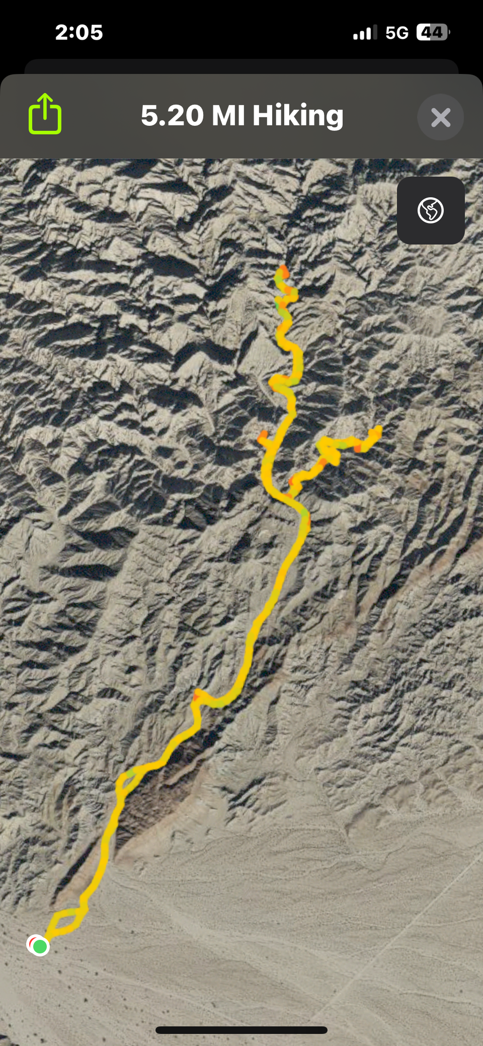
Distance: 5.2 miles
Elevation Gain: 568 feet
Difficulty: Moderate
Terrain/Obstacles: Maintained dirt road with minor obstacles. Sandy wash.
Hike Breakdown: Hike is suitable for a novice hiker who wants a challenge
Best Time: October–April
Highlights: Hiking on the San Andreas Fault system, red fault gouge hills, slot canyon
TrailsNH Hiking Difficulty Calculator: 77 – Moderate

Click here to navigate to the TrailsNH website for a description of the hiking difficulty calculator.
Where the Earth Breaks Open
Skeleton Canyon isn’t just a hike; it’s a walk through one of the most actively deformed landscapes in the Mecca Hills. Tucked within the fractured edge of the San Andreas Fault system, this canyon exposes the raw mechanics of crustal movement: pulverized fault gouge, tilted sediment layers, and mineral-stained walls that record cycles of stress, rupture, and fluid flow. What begins as a straightforward desert hike quickly becomes a field study in tectonics, where each bend in the canyon reveals how the Earth’s crust breaks, shifts, and rebuilds itself over time.


Where Skeleton Canyon Sits Within the San Andreas Fault System
The Mecca Hills are cut by a network of faults within the San Andreas Fault system, but in Skeleton Canyon, you are standing directly on the San Andreas Fault itself. According to the California Department of Conservation’s interactive fault activity map, the canyon entrance (circled in blue) lies along the San Andreas Fault and sits adjacent to the Skeleton Canyon and Painted Canyon fault strands.

What Makes Skeleton Canyon a Fault Zone Study
🟫 Quick Answer
A fault zone isn’t a single break—it’s a system of zones. In Skeleton Canyon, you move between crushed rock (fault core), tilted layers (deformation zone), and more stable, layered terrain (damage zone), depending on where the fault cuts through the landscape.
Skeleton Canyon offers a rare, ground-level view into the inner workings of the San Andreas Fault system, where a fault is exposed not as a single break, but as a series of deformation zones. Within a short stretch of canyon, you can encounter multiple expressions of that deformation:
Fault Core → rock is crushed and structure erased, the most intensely broken ground
Fault Damage Zone
Early Deformation Zone → layers tilt but remain intact.
Intensely Fractured Zone → rocks are tilted, folded, and fractured.
You won’t walk through these zones in a neat sequence. The fault bends and branches beneath the canyon, so what reaches the surface is uneven and patchy. As you hike, zones emerge where the fault is exposed, then fade where it dips away—creating a landscape where the same zone can appear more than once.
Together, these features make Skeleton Canyon a natural field laboratory, one where you can observe how fault movement creates a gradient of deformation, and how rock, water, and stress interact to shape the landscape at every scale.


Fault Core: Walking Through the Most Broken Ground
What Is the Fault Core
At the start of the hike, you’re not just walking along the San Andreas Fault—you’re passing through the fault core. The fault core is the active heart of a fault system: the zone where blocks of the Earth’s crust actually slide past one another. Over time, repeated motion concentrates strain in this relatively narrow band, typically about 100 – 300 meters wide at the surface. Within this zone, deformation has reached its most extreme state. They are not fractured rock; they have been intensely deformed, broken, and structurally reorganized.

What is Fault Gouge
Rocks caught between the grinding teeth of the San Andreas fault core are pulverized and chemically altered by repeated movement into a loose, clay- to sand-sized material known as fault gouge. This material is characteristic of the fault core and is often iron-stained red from oxidation. Unlike intact bedrock or sedimentary rock, it lacks cohesion, making it highly susceptible to erosion.
A close-up shows the material’s loose, unconsolidated texture, illustrating its high susceptibility to weathering and erosion. Now that you know what fault gouge is, you’ll start noticing it everywhere on the trail.

How Old is the Fault Gouge
Fault gouge cannot be dated precisely because each movement along a fault crushes new rock and mixes it with older material. By the time gouge reaches the surface, it has been repeatedly reworked and chemically altered, erasing any single formation age.

Why Does Soft Fault Gouge Form Tall Hills
Fault gouge may crumble easily, but in places like Skeleton Canyon, it accumulates to form tall hills because the San Andreas Fault is actively pushing material upward. As erosion wears away the surface, new gouge is constantly lifted into place.
Gouge-rich zones form some of the most distinctive terrain in the Mecca Hills: soft, deeply weathered, red-stained, crumbling hills. How can easily eroded materials form these hills? In places like Skeleton Canyon, you’re in a transpressional zone along the San Andreas Fault.
The plates aren’t just sliding past each other—they’re also squeezing together.
That compression pushes material upward, including fault gouge.
Even weak material can form hills hundreds of feet tall if it’s being continuously uplifted.
Fault gouge hills don’t exist because the material is strong. The hills exist because the San Andreas Fault keeps delivering crushed material upwards faster than erosion can completely remove it.

Why the Red Hills Disappear and Then Reappear Down Canyon
🟫 Quick Answer
Red fault gouge hills appear and disappear because the canyon does not follow a straight path along the San Andreas Fault. As the canyon cuts into and away from the fault core, soft gouge is alternately exposed and hidden.
As you move through Skeleton Canyon, the red hills seem to come and go—replaced at times by more solid, resistant rock before returning farther downstream. This shifting landscape reflects how the canyon intersects a fault zone that bends, branches, and steps laterally rather than following a single continuous line.
Where the canyon slices directly into the fault core, weakened gouge is exposed and rapidly eroded into red, crumbling hills.
Where the canyon shifts away from the core, more intact rock dominates the landscape.
In some sections, stronger layers partially cover or obscure the gouge.
The result is a repeating pattern: the canyon alternately intersects and bypasses gouge-rich zones, causing the red hills to fade out …

… and re-emerge as you move downstream.

Reading the Landscape
At first glance, Skeleton Canyon looks like a maze of red hills and narrow passages. But once you know what to look for, the landscape becomes a readable record of movement along the fault core. When layering disappears and the ground crumbles in your hand, you are in the heart of the fault core. Additional clues include:
No visible layering or continuous bands
Soft, crumbly red material that breaks apart easily
Smooth, rounded but unstable hills that erode faster than the surrounding rock
A lack of solid, continuous bedrock

From the Fault Core Into the Fault Damage Zone
As you move away from the fault, the landscape enters a broader region known as the Fault Damage Zone, an area where tectonic stress has pushed the rock beyond gentle bending and into fracture. For simplicity, this zone can be viewed in two broad stages:
Early Deformation Zone: layers begin to lose continuity but remain partly intact and still recognizable across the landscape.
Intensely Fractured Zone: rock is more heavily broken, and the terrain takes on a sharper, rougher, and more unstable form.
This transition does not unfold in a neat, orderly sequence. The fault does not follow a straight line; it bends, branches, and shifts position through the landscape. As a result, these zones of deformation may appear and disappear along your route rather than lining up in a predictable order.
Reading the Landscape: What the Early Deformation Zone Looks Like in the Field
This landscape fits squarely within the Early Deformation Zone because it shows the first visible effects of tectonic stress. The rock has been tilted and reshaped, but it has not yet been broken apart. Classic features in this zone include:
Continuous, Traceable Layers
The hills display clear bands of light tan, gray, and off-white sediment. These stacked layers were originally deposited as flat sheets in the basin that existed here millions of years ago. Each band reflects a time when different sediment types were carried into that calmer environment.
Gentle Tilting, Not Chaos
The layers are mostly horizontal to gently dipping, especially across the central and upper slopes. They have not been violently folded, fractured, or shredded. Instead, they show subtle tilting, the kind of early deformation that signals tectonic stress beginning to reshape the landscape while much of the original structure remains intact.
The foreground hills look like they’re layered in different directions. However, what matters in the Early Deformation Zone is not whether layers look complex, but whether they are broken.

Rounded, Cohesive Landforms
The hills are smooth and flowing rather than jagged. This indicates soft, fine-grained sediment that is eroding evenly and not breaking apart along fractures in the rock.
Erosion Follows the Slope, Not Fractures
The vertical rills and grooves are carved by water running downhill. They cut across the layers but are not controlled by fractures, which would create sharper, more angular features.

This scene likely sits near the outer edge of the Early Deformation Zone, where gentle tilting begins to give way to more noticeable strain. The hills form steep, triangular, wedge-shaped faces, suggesting the original flat layers have been tilted at a significant angle. Yet the slopes do not show the chaotic folding, shattered rock, or sharp offsets typical of more intensely deformed areas.
Deep vertical gullies and narrow chutes cut down the slopes, indicating the material remains relatively soft and fine-grained. Runoff is still the main force shaping the landscape here, carving channels directly into the sediment rather than following fractures or broken rock zones.

Key Takeaways
In the Early Deformation Zone, rock layers are still recognizable, but fractures and tilting show the first effects of tectonic stress. The landscape remains relatively orderly, marking the early stage of the fault damage zone before deeper areas become more.

Entering the Intensely Fractured Zone
What makes Skeleton Canyon so fascinating is how quickly the geology changes: calm, horizontal layers in one spot, then a short distance away, a more disrupted phase where bending gives way to breaking. Layers that were once continuous become difficult to trace, cut apart by fractures and broken into angular blocks. Slopes grow steeper and rougher, and the terrain feels less cohesive, signaling that you have entered the Intensely Fractured Zone, where tectonic stress is strongly reshaping the rock.
Reading the Landscape: What the Intensely Fractured Zone Looks Like in the Field
This scene is typical of the Intensely Fractured Zone, where tectonic stress has exceeded the rock’s ability to bend, causing it to crack and break apart. Compared with the earlier deformation zone, this area looks and feels less coherent and less stable. When the landscape is dominated by broken rock blocks rather than clearly traceable layers, you have likely entered the Intensely Fractured Zone. Common features include:
Rock Broken into Blocks and Slabs
The hillside is no longer smooth or shaped by clearly continuous layers. Instead, the rock has fractured into angular blocks, steep ribs, and jagged ridgelines, while the original layering becomes difficult to follow. The surface also takes on a more mottled and blotchy appearance.
Multiple Fracture Directions
Cracks and breaks run at several angles: vertical, diagonal, and intersecting. This suggests the rock has undergone repeated episodes of stress, rather than simple tilting alone.

Deep Within the Intensely Fractured Zone
This is one of the more dramatic views of the Intensely Fractured Zone. It shows an area where tectonic stress has extensively broken and reorganized the rock. When canyon walls are shaped more by cracks, narrow stone fins, and jagged blocks than by visible layers or smoother slopes, you are deep within this zone.
Vertical Fractured Walls
The canyon wall is divided by deep, nearly vertical cracks that form tall fins. These are not simple erosion grooves, but major structural fractures later widened by weathering.
Rock Split into Upright Slabs
Instead of broad hillsides, the rock has been broken into upright slabs, blocks, and columns. This reflects strong brittle deformation, where the rock no longer bends as a single unit. Much of the original layering has been obscured by structural damage.

A Slice of Rock Trapped Between Faults
This scene provides another example of intensely fractured and eroded sedimentary rock. The dark central pyramid-shaped feature may represent a narrow slice of rock trapped between two faults, often referred to as a fault-bounded sliver. Like most sedimentary layers in this canyon, it was likely originally deposited horizontally, later cemented into rock, and eventually rotated into a steep position. Evidence supporting this interpretation includes:
The pyramid-shaped block shows sharp fractures and narrow grooves that terminate abruptly, rather than layers folded into gradual bends.
It has straight, distinct boundaries rather than the curved bending patterns seen in the adjacent canyon walls.
The block appears darker, more resistant, and more angular than the surrounding rocks, which are lighter colored, smoother, and more easily eroded. That contrast suggests it may differ in composition or cementation from adjacent units.
These contrasts in structure, orientation, and erosion resistance suggest separate structural blocks may be present here, making a fault-bounded sliver a plausible explanation.
Where fault-bounded slivers are made of more resistant rock, they often erode more slowly than the surrounding material. Flash floods likely removed less resistant material around it, isolating the spine. The result is a striking rock ‘island’ rising above a landscape of shattered slopes. In a canyon filled with striking signs of tectonic upheaval, this stands out as one of the more unusual and distinctive geologic features.

Key Takeaways
In the Intensely Fractured Zone, cracking and breakage dominate the landscape. Rock layers are disrupted into fins, blocks, and steep walls, revealing where tectonic stress was concentrated most intensely within the fault damage zone.

In Search of Slot Canyons
On several trips, Dave and I explored random openings in the canyon sidewall in search of new routes. We weren't very successful; in most cases, the openings closed up quickly.
Chris joined us on one of these adventures. Although we weren't successful in finding a new route, it was still a fun time.


Finding a Slot: Third Time Is A Charm
They say, 'third time's a charm,' and it's true. During our third trip to Skeleton Canyon, we decided to explore an opening that appeared larger than most, and it was an excellent choice.

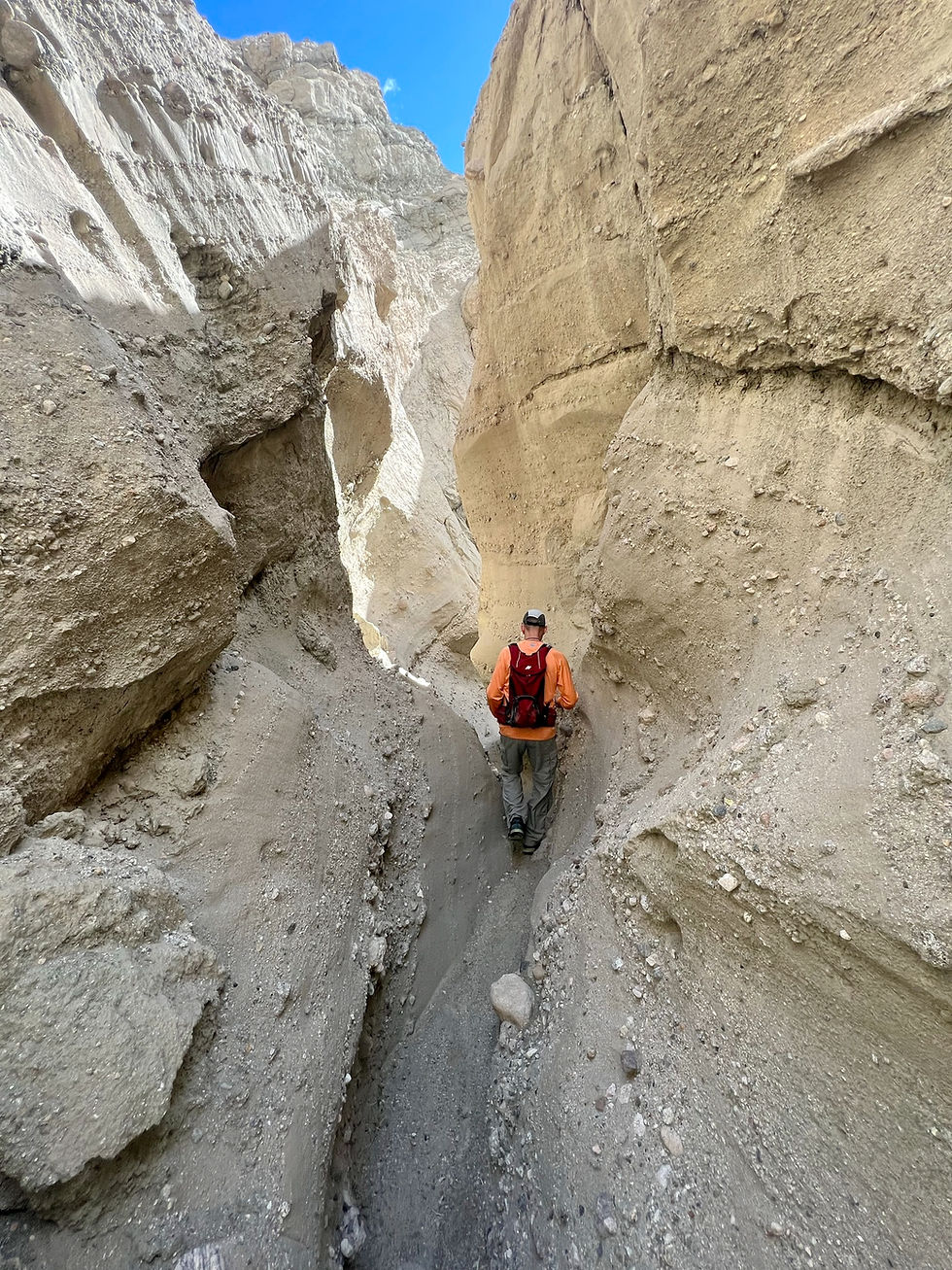
Entering the Hidden Narrows
At first, the canyon gives little warning of how tight it will become. Broad walls suddenly draw inward, and the wash turns into a winding corridor. Smoothed walls, undercut curves, and polished surfaces reveal the force of past flash floods that carved this dramatic slot deep within Skeleton Canyon.

Why the Slot Canyon Forms Here
At first glance, Skeleton Canyon may seem like an unlikely place for a tall slot canyon. Much of the surrounding rock has been fractured and weakened by fault movement, conditions that often produce broader gullies and unstable slopes. Yet the canyon also contains a patchwork of more resistant layers—better-cemented sandstone, conglomerate, and compact siltstone—that can hold steep walls long enough for floodwaters to cut narrow passages through them.

Where Softer Rock Yields To Water
Poorly cemented sandstone, siltstone, and mud-rich layers are among the less resistant rocks in the canyon. During flash floods, these weaker materials erode more readily than harder beds nearby. Instead of forming only narrow slots, they can weather back and wash away faster, creating broader passages, gentler slopes, and wider bends like the section seen here.

Well-cemented conglomerates and compact sandstone are more resistant rock layers. When floodwaters cut through these stronger materials, erosion is often focused downward along the channel rather than rapidly widening the walls. The result can be a narrow passage with steep sidewalls and only limited wall retreat. When these rocks do fail, they commonly fracture along joints or cracks in cleaner, more blocky pieces rather than slumping into loose piles, helping the canyon remain tight and confined.

If you pause while walking through the slot canyon, the changing shapes of the walls begin to make sense. They are not random, but reflect a patchwork of more resistant and less resistant rock within the faulted canyon. Some layers remain steep and narrow, while weaker zones weather back into ledges, loose sand, and sloping debris. Once you notice these contrasts, the canyon becomes easier to read—each bend showing how rock strength and flowing water worked together to shape the passage.

Every bend reflects how fast-moving water exploits weaknesses in the canyon walls. From a distance, the passage may appear uniformly smooth, but up close, the rock responds in very different ways. On the left, the wall appears softer and more crumbly, likely composed of finer-grained sediment that weathers into rounded ledges and loose debris on the canyon floor. On the right, the rock is smoother and more cohesive, probably better-cemented sandstone and siltstone that can maintain a steeper face long enough for flash floods to carve curves, grooves, and polished surfaces.

In this section of the slot, you can see how different rock layers respond to the same forces in contrasting ways. The wall on the right appears to be made of more resistant, better-cemented sandstone and siltstone. Although fractured by fault-related stress, it remains cohesive enough to erode into smooth, sweeping curves rather than collapse.
The wall on the left looks rougher and more crumbly, likely because it contains weaker, finer-grained sediment with less cementation. That material softens and breaks down more easily during floods, allowing flowing water to remove loose pieces and widen the passage on that side. The result is a canyon shaped by both rushing water and differences in rock strength.

Carved by Swirling Water
The graceful curves in these slot-canyon walls reflect how well-cemented sandstone, pebble-rich conglomerate, and compact siltstone respond to repeated flash floods carrying sand and gravel. Even where faulting has fractured the rock, mineral cements still bind many of the grains together, allowing the walls to erode into smooth surfaces rather than simply crumble apart. As floodwater rushes through a narrow passage, it accelerates and forms swirling eddies and corkscrew-like currents that scrub the canyon walls instead of cutting straight down the middle. Over time, those corkscrew flows shave these walls into smooth, curving surfaces.

A Fracture in the Wall
There is more to see than weak and strong rock layers and curved canyon walls. Up ahead on the wall is a large vertical crack. These straight fractures are signatures of the San Andreas Fault System; evidence of rocks being stretched, squeezed, and shifted as blocks grind past one another. It's a reminder that without the fault zone beneath our feet, these dramatic passages and canyons wouldn’t exist.

Time to Turn Around
There isn’t a single endpoint in this segment of the canyon. It continues, but after a long stretch, the canyon begins to open, the walls begin to shrink, and debris clogs the path.

Our decision to turn around is usually based on a combination of factors, including water supply, temperatures, and when we’re satisfied with the day’s effort.

One last photo before we return to the main wash.

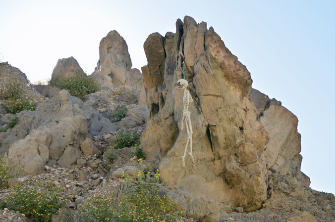
After all this discussion about fault zones, shattered rock, and narrow walls, Skeleton Canyon still leaves room for a little humor. Somewhere along the route, a hiker added this unexpected resident to the canyon wall. Sometime during 2025, the skeleton was dislodged from the hanging apparatus. We found it sitting in the wash about 1 mile downstream from its original spot. Maybe we should return it to its proper location?


What Skeleton Canyon Reveals
Walking through Skeleton Canyon is like moving through stages of tectonic strain. More intact layered rock gives way to zones of increasing fracture and breakage, showing how stress intensified toward the fault core. The narrow slot canyon adds another chapter, where water exploited weakened rock and carved a passage through the damaged zone. What looks chaotic at first often has a clear geologic story behind it. Together, faulting and erosion created a landscape where geologic forces are not just visible—they are part of the hike. Once you learn to read this terrain, you don’t just hike through it—you begin to see the story written into the land.

If Skeleton Canyon sparked your curiosity, explore my other Mecca Hills hiking blogs, where fault canyons, desert trails, and striking rock formations reveal more of this remarkable landscape. Start with these nearby hikes and geology guides:
After squeezing through the narrow passages of Skeleton Canyon, head to Red Hill Vista to step back and see the bigger picture: striped badlands, uplifted sedimentary layers, and a panoramic view of the tectonic forces that shaped the Mecca Hills.
Explore How Red Hill Vista and Skeleton Canyon Reveal the Geology of the Mecca Hills to see how these two hikes provide complementary perspectives—one revealing the striped badlands from above, the other taking you deep inside the same folded rocks.
Skeleton Canyon FAQs
When did the San Andreas Fault begin affecting the Mecca Hills area?
The southern San Andreas Fault system began influencing the Coachella Valley–Mecca region by about 6 to 8 million years ago, but the rock record exposed in the Mecca Hills mainly preserves younger deformation from the last 3 to 5 million years. That is when sedimentation, uplift, and folding became strongly recorded in the strata seen today.
When did the ancestral Colorado River begin depositing sediments in the Mecca area?
Large-scale river and basin sedimentation in the Mecca Hills was underway by the Pliocene epoch, with major deposits accumulating from about 3 to 5 million years ago. These sediments were carried through evolving river, fan, and basin systems tied to the early Colorado River–Salton Trough region.
When did the major uplift events occur in the Mecca Hills?
Two major uplift periods occurred:
~2.6 million years ago — a major tectonic change caused uplift, tilting, and an angular unconformity in the Palm Spring Formation.
~0.7 million years ago — uplift accelerated again, helping expose and erode the Mecca Hills into the rugged landscape seen today.
Uplift likely occurred in pulses rather than one single event.
What geologic era shaped most of the modern Mecca Hills?
Most of the visible landscape formed during the late Cenozoic Era, especially the Pliocene and Pleistocene epochs (roughly the last 5 million years), when fault motion, uplift, and erosion intensified.
What is the Fault Core Zone?
The fault core zone is the central part of a fault where movement was most concentrated. Rock here is often crushed, sheared, and broken into finer material.
Did the Fault Core Zone help shape Skeleton Canyon?
Yes. Zones of broken, weakened rock often become natural pathways for erosion, helping washes and canyons develop along the fault trace.
Why is the Early Deformation Zone important for hikers and geology enthusiasts?
It offers a clear view of how rocks respond in the early stages of tectonic compression before deformation becomes more chaotic.
Why do the layers remain visible in the Early Deformation Zone?
Stress affected the rocks, but not enough to completely break them apart. Many original sedimentary layers still hold together despite bending and cracking.
How does the Intensely Fractured Zone continue influencing canyon formation?
Water can exploit the many fractures, carving gullies, slots, and steep-walled passages along zones of weakness.
Why does the Intensely Fractured Zone feel more rugged and unstable?
Because the rock has lost much of its original cohesion, slopes are often steeper, rougher, and more prone to shedding loose debris.
How were the slot canyon walls carved so smoothly?
Repeated flash floods carrying sand and gravel scoured the walls over time. Swirling water and abrasion gradually polished rough rock into curved, smooth surfaces.
07112025


Comments