Why the Mecca Hills Are so Tortured: The Geology of Twisted Canyons Hike
- Jan 31, 2025
- 13 min read
Updated: May 21
Welcome to Chuckwalla National Monument
The Mecca Hills Wilderness was created in 1994 when the U.S. Congress designated 26,356 acres in the Mecca Hills to be overseen by the U.S. Bureau of Land Management (BLM). In January 2025, the Mecca Hills Wilderness and an additional 600,000+ acres were further protected by presidential proclamation establishing the Chuckwalla National Monument (CNM).

This map outlines the boundary of the CNM and Mecca Hills Wilderness area within the monument. CNM is among the largest national monuments by acreage in the United States.

Without a doubt, Mecca Hills Wilderness is our favorite place to hike in Southern California. We first visited this area in 2017 and return here often for its unparalleled beauty and limitless hiking opportunities. From peaceful desert washes to exciting slot canyons, this region, formed by the destructive power of the San Andreas Fault network, has something for every type of hiker.


A Geology Primer: How the Mecca Hills Formed: Faults, Uplift, and Erosion
Before jumping into the hiking experience, it's worth spending a few minutes reviewing the geology of the Mecca Hills. This relatively small range of low, rugged hills lies directly on the San Andreas Fault network, where the Pacific Plate and North American Plate grind against each other. The rocks of the Mecca Hills have been uplifted, deformed, and broken by fault activity, creating a landscape of steep ridges, canyons, and deeply incised washes.

The California Department of Conservation website provides access to an interactive fault activity map that showcases the dense cluster of faults that ring the Mecca Hills. By entering latitude and longitude data, the site pinpoints the location in relation to known faults. In our case, Twisted Canyons trail is located directly on the Skeleton Canyon Fault (marker circled in blue), which in turn is sandwiched between the Painted Canyon and San Andreas Faults.

When It All Began: The Forces That Set Things In Motion
Approximately 5 to 6 million years ago, when the San Andreas Fault became active, this area, originally a low-lying basin, started accumulating sediments. These sediments originated from erosion of the nearby mountains and from sand and silt carried by the ancestral flow of the Colorado River. The Colorado is believed to have flowed through the Coachella Valley and into the Pacific Ocean from 5.3 to 2.3 million years ago. How much sediment was deposited? Surveys indicate there is a 3-mile-thick layer of sediment deposited on bedrock in this region.
As these sediments were deposited over millions of years, the underlying layers were compacted and cemented into sedimentary rock. In areas where sedimentary rock has not been significantly altered by fault movement, bedding planes resemble horizontal bands, like those in this photo. Each layer indicates a different period of sediment deposition.

Around 2 to 3 million years ago, significant activity along these faults, particularly transpression—a combination of lateral sliding and squeezing—resulted in the uplift of older basement rocks and the sedimentary rocks layered above them. As the rocks were pushed upward along fault lines, sedimentary rocks that were once horizontal became tilted and squeezed into tightly compressed near-vertical folds. These folded sandstones, behind Dave, are part of the Palm Spring Formation that was deposited 3 million to 76,000 years ago.

Why Hike Twisted Canyons
Twisted Canyon begins as a broad desert wash, but soon bends into narrow passages, sculpted walls, and hidden corridors tucked deep in the Mecca Hills. Compared with the more famous ladder routes nearby, this canyon feels quieter, wilder, and more exploratory.
At first glance, the ridges of the Mecca Hills look chaotic, layers of rock bent, tilted, and folded into sharp angles. But there’s order hidden in that disorder. The twisting landscape of Twisted Canyons reflects millions of years of movement along the San Andreas Fault, where pressure reshaped entire layers of sediment. Understanding what you’re seeing turns this hike into something more than a walk through a canyon; it becomes a glimpse into how desert landscapes evolve.
Let's Start Hiking Twisted Canyons
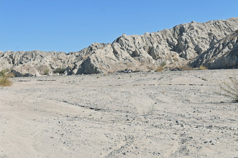
The Twisted Canyons trailhead is located on Box Canyon Road and starts in Box Canyon Wash (coordinates: 33°35'25.8"N 115°58'23.2"W). The wash extends for 16+ miles on both sides of the road.

This image of Box Canyon Wash near the trailhead and the satellite image of the same spot (where the box photo represents the trailhead) highlight the wash's width along this section of the road.


Life in the Desert Wash Habitat
Juvenile smoke trees, less than 6-8 inches tall, stretch along Box Canyon Wash for as far as the eye can see. If they all survive, we’ll have a smoke tree forest in a decade. Plant specialists within FODM have differing opinions as to whether these trees germinated after the monsoon rains of 2019 and 2020 or after Tropical Storm Hillary in 2023. Either way, it will be interesting to watch their survival rate in the coming years.

Further in the wash, there are numerous adult smoke trees. They endure extreme temperatures and drought conditions through various specialized adaptations. Their flexible branches and strong root systems allow them to withstand the force of floodwaters and quickly take advantage of the moisture. Smoke tree can send down very deep taproots—sometimes 20 to 60 feet. However, they still depend on feeder roots within the top 12 to 18 inches of soil for quick access to water during brief rain events.

Smoke trees have almost no leaves, but their gray-green branches carry out photosynthesis directly. The lack of leaves helps to minimize water loss through transpiration. Like many members of the pea family, smoke trees host nitrogen-fixing bacteria in their root nodules. The bacteria convert air nitrogen into a usable form for plants. This process enriches the soil with nitrogen—a key nutrient for plant growth. This adaptation helps smoke trees survive in dry areas like the Sonoran Desert, where nitrogen is lacking in the sand and gravel.

The Twisted Canyons trail truly starts once you cross the Box Canyon Wash and enter the wash that leads to the surrounding hills and canyons. At this point, we also enter the 'Mecca Hills structure.'

Although the wash is dry right now, that's not always the case. Rainstorms, although rare, bring sheet flow as water pours off the nearby hills and drains into the wash. Very little of the fast-moving runoff penetrates the dense, compacted sand of the wash. In order to survive, desert shrubs like this sweetbush produce lateral shallow roots that are able to capture significant amounts of fast-moving runoff.

Plants like this creosote and brittlebush thrive especially well along the edges of the wash where runoff is slower, and water is more readily absorbed by their roots. The color of creosote leaves can be an indicator of their hydration levels. Wilting, curling, or yellow/brown discoloration of their leaves suggests the plant needs more water. Conversely, deep green leaves like these indicate a well-hydrated and healthy plant.

The same goes for this brittlebush. Silver-gray leaves are a sign of a healthy, well-hydrated brittlebush. The leaves reflect sunlight and help the plant regulate its temperature. The brown, brittle stems emanating from the leafy areas of a brittlebush are last season's dried flower stems.


For plants, survival largely depends on their proximity to areas where rainwater flows or collects. Just a few feet away from these thriving plants, a beavertail cactus suffering from severe dehydration and a drought-stressed Mecca Aster shrub struggle to survive. Both plants are adept at managing drought conditions by entering dormancy and conserving water. Nonetheless, in cases of the extended drought that we’ve been experiencing, even their adaptability will eventually be exhausted.


Please remember to step gently when you hike in a wash. Rainwater runoff from the hills carries loose soil, organic material, and seeds and deposits them in the wash. When conditions are right, these seeds germinate. The prairie clover (top left), burro bush (top right), wand holdback (bottom left), and Mecca aster (bottom right) are just a few of the many plants we saw sprouting in the wash in late January.


Rainwater runoff also has destructive implications. At least 3 feet of sediment has been eroded from the wash, resulting in a hanging root system for this tree. A general rule of thumb, if more than 25–30% of the visible upper root mass is exposed—particularly near the crown—the tree faces a high risk of death. Exposed roots dry out and suffer from sun scald, especially when summer temperatures exceed 100°F. This tree lost its battle against the forces of nature quite a while ago.

The Three Forces that Created the Twisted Canyons Maze
The Mecca Hills are renowned for their canyons. In Twisted Canyons, the three processes essential for forming the maze of canyons converge seamlessly.
Uplift & Folding
As previously mentioned, this region of the desert has experienced fault-induced uplift for the last 2 to 3 million years, with a significant increase occurring 700,000 years ago. Research suggests that basement rock in this region has been vertically raised 10,000 to 16,000 feet. This uplift intensified runoff from the nearby mountains, greatly accelerating the rate of erosion and significantly transforming the landscape.
This photograph is a great example of uplifted sedimentary rock layers in Twisted Canyons. The yellow line highlights a bedding plane that was originally laid down horizontally but has been uplifted to an angle exceeding 30°.

Faults & Fracture Zones
As shown in the Map of Fault Activity displayed earlier, multiple faults traverse the Mecca Hills. Movement along these faults generates zones of weakness and fractures in the bedrock and surface geology. Over time, these weak zones become natural pathways for water to flow through the rocks, making them even more prone to erosion.
Erosion
The core of canyon formation is the interaction between water and rock, particularly how runoff and flash floods over hundreds of thousands or millions of years have shaped sedimentary rock layers in active fault zones. Seasonal rain, especially during flash floods, sends surges of water through these fractured and folded sedimentary rocks. These floods transport sediment and debris that function like sandpaper, carving into the rock and gradually deepening the canyons. This process is particularly effective in the Mecca Hills, where softer sedimentary rocks erode more readily than harder rocks.

When Twisted Canyons' Walls Start to Close In
After slightly more than half a mile, our trail breaks from the main wash and follows a smaller canyon opening on the right.

Almost immediately, the trail splits again. To the right, a narrow canyon, and straight ahead, a much wider canyon. We chose to explore the narrow canyon first.

The steep canyon walls create shade and reduce evaporation, providing brief periods of cooler temperatures and better moisture retention— a microclimate of sorts.

Mecca Asters Thrive In a Shifting Landscape
Mecca asters are endemic to these hills, existing here and nowhere else on the planet. The canyon's aster plants were lush with leaves but sparse in flowers. Only last season's blooms were evident. This woody perennial shrub, characterized by its lance-shaped leaves, can reach a height of 4 feet. They thrive in fine sand and silt where moisture persists longer and are commonly found along the wash margins and eroded slopes of the canyon. They tend to pop up in small clusters rather than in a massive carpet. For much of the year, they look like ordinary drought-stressed shrubs, making them easy for hikers to overlook.

Their woody stem structure helps reduce water loss and can store moisture during dry spells. A deep and spreading root system helps the plant draw moisture from a large surface area.

To bloom, the Mecca aster relies on measurable rainfall events during late winter and early spring. Considering that the Coachella Valley has seen minimal rainfall over the last 13 months and this winter has also been exceptionally dry, it's astonishing that we noticed any blooms at all.

Spotting a Mecca aster in bloom is always a highlight during our hikes, and we encourage everyone to appreciate these moments when we encounter them. Sadly, the Mecca aster is considered highly vulnerable to climate change because of its restricted range, specific habitat, and the rising temperatures and increasing frequency of drought.

It didn’t take long for the canyon to become narrower. Here, the canyon walls rise higher and close in, showing how repeated storm flow is concentrating energy into a confined path. The smooth sandy floor marks the active channel where water funnels during storms, driving ongoing vertical incision, deepening the canyon while narrowing it into a developing slot canyon.
A few additional clues show this canyon is still evolving toward a tighter slot. The area circled in orange marks a small, resistant patch of more strongly cemented sediment. Even at this scale, it matters—small differences in rock strength guide erosion. During storms, flow is diverted around these tougher spots, focusing downward cutting into the sandy channel rather than widening the walls through differential erosion. On the right slope, loose debris points to periodic wall collapse. As undercut slopes give way, fallen material accumulates along the margins, gradually narrowing the passage over time.

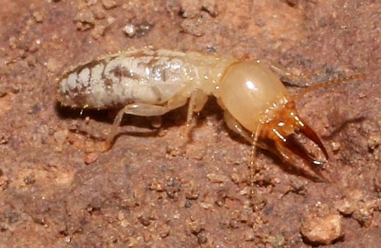
A Hidden Sign of Life: Big-Jawed Termite Tubes
One advantage of having a subject matter expert prehike the trail is their ability to discover hidden gems that we might otherwise miss. One such discovery was the big-jawed termite tubes at the base of several plants. Until Ada and Susan pointed them out, neither Dave nor I, along with most FODM hike participants had ever seen them on previous hikes.

What are these tubes? They are protective foraging sleeves constructed from a type of termite cement composed of soil, saliva, and fecal material. Termites create these mud tubes to shield themselves from predators like lizards and birds while moving and foraging above ground. Without an exoskeleton, termites are highly vulnerable to drying out; the tubes also help maintain moisture and protect them from the scorching sun.

Worker termites use 'termite cement' to construct narrow tunnels beginning at their nest or the base of a plant. As they continue to forage on the plant, upwards, they extend these tubes around individual stems. Despite building around living stems, they generally do not harm healthy plants. They are not herbivores; their diet is focused on dead and decaying organic materials. It's easy to see how these termites earned their name. Photo courtesy of iNaturalist.


Where the First Canyon Comes to an End
The further up canyon we traveled, the more obstacles we encountered.

It wasn't long before the trail came to an end. We couldn’t navigate past this narrow opening, which was blocked by sand and debris at the other end.
The Second Canyon: Towering Walls & Widening Floor
What makes this hike especially enjoyable is that after the narrow canyon comes to an end, we head back to the trail split and begin exploring the second canyon.

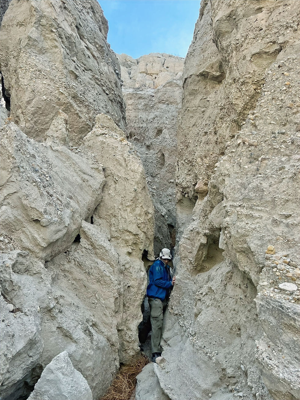
As we approached this narrow opening, the canyon walls began rising dramatically.

It's easy to envision that the gap where Susan stands eroded over time and was originally a solid rock wall.

Why the Canyon Widens: Erosion at Work
When flashfloods roar through a canyon like this, the runoff is thick with sand, cobble, and boulders, which geologists refer to as a sediment-laden flow. This chaotic debris flow hammers the canyon walls and acts like sandpaper, grinding and scouring the rock surface. This process is particularly effective in soft sedimentary rocks, which are more easily worn away. Whether a canyon becomes wider or deeper is determined by several factors.
If the canyon floor is littered with boulders or has tightly compacted sedimentary layers, then vertical cutting slows down and the water's force is redirected sideways, cutting into the sidewalls, as in this section of the canyon.

There is also the ‘weak wall effect’. Certain sections of this canyon have fragile and easily eroded sidewalls. Steep sidewalls made of soft rock layers and loose sand can easily give way during rainstorms. These collapses cause the canyon to widen in large segments — a process called mass wasting. The result is a canyon that grows in sudden bites.

Sidewalls composed of soft sedimentary rock can’t resist the undercutting. Here, the floods have been steadily nibbling away at the base of the sidewall above Dave's head. It's just a matter of time before gravity takes over and more of the sidewall sloughs off to continue the canyon widening process.

Here Dave and Susan are engaged in a deep conversation as he preps to lead his first FODM hike. Both Susan and Ada are exceptional mentors for both new and seasoned hike leaders. As anticipated by everyone, Dave was great.

What to Look For Along the Trail
Hiking with FODM subject matter experts highlights the importance of slow, deliberate hiking to reveal more of the wilderness offerings. Susan and Ada found these spider webs surrounding a pencil-sized hole in the canyon walls. What a clever way to catch prey; as creatures investigate the opening, they get ensnared in the web, becoming the spider's next meal. Unfortunately, we couldn't determine which species of spider spun the web or the insect that bored the initial holes.


It's not quite as impressive as spider traps, but Dave and I managed to find an abandoned hummingbird nest 7 to 10 feet above the ground in a creosote bush. The nest is made of soft materials like moss, lichen, and fur that are bound together with spider silk. The spider silk helps the nest expand as the hatchlings grow. Hummingbirds choose locations like this that offer both shelter from the elements and camouflage from predators.

Why This Slot Canyon Narrows and Twists: A Geologic Shift
The power of water can be fickle; occasionally, the second canyon would unexpectedly narrow and ...

...at times become slot-like.

The Hidden Strength in These Walls
The trail actually continued through this crevice in the rock. There is hidden strength in these walls. The keys that let these walls stand while the canyon snakes around them come down to a few reinforcing factors.
Cementation
Some zones in these sediments have been more tightly bound by minerals in a process called cementation. Where cement is stronger, the wall resists erosion; where it’s weaker, water carves faster.

Large Clasts
Mixed into the walls are pebbles and small cobbles or clasts. This coarse material forms a loose version of conglomerate, adding durability much like aggregate strengthens concrete. Where these clasts are concentrated, erosion slows. Variations in cementation and the presence of larger clasts drive differential erosion, shaping the canyon into a series of fun navigation challenges.

Why the Twisted Canyons Slot Walls Form Wavy Patterns
When stormwater moves through the slots, it doesn't erode everything evenly. Smoother sandy zones are scoured more easily, while pebble-rich or better-cemented patches resist wear. The contrast known as differential erosion causes water to slot slightly from side to side as it flows through the slot.

As stormwater encounters a more resistant patch, it is deflected around it, cutting more deeply into adjacent, softer sediment. With each flood, these small deflections are reinforced, gradually exaggerating curves in the channel. Over time, this produces the wavy, sinuous pattern—where alternating zones of erosion and resistance guide the flow into a gently winding path rather than a straight line.

We followed the canyon for about 1.5 miles as it continually widened and narrowed, then decided it was time to head back to the trailhead.

By the time we returned to the trailhead, the sun was low on the horizon, creating 'golden hour' lighting.

Final Thoughts from the Trail
Twisted Canyon feels like discovering a secret chapter of the Mecca Hills-less known than Ladder Canyon, quieter than Painted Canyon, yet every bit as dramatic.
As you step out of Twisted Canyons, pause for a final look. The walls around you are still being shaped, flash floods quietly carving deeper into layered sediment. Here in the Mecca Hills, nothing remains unchanged for long.
If you find yourself looking more closely at the rock around you, you’re not alone. The desert rewards that kind of attention. For more hikes where geology shapes the experience, explore the rest of the site, including the related posts identified below.

Twisted Canyons Hike Overview
Location: Mecca Hills Wilderness
Trail Type: Out and Back
Distance: 4.5 miles; shorter version - 2.3 miles
Elevation Gain: 403 ft; shorter version - 250 ft
Difficulty: Moderate; shorter version Easy
Hike Breakdown: Hike is suitable for a novice hiker who wants a challenge
Best Time: October–April
Highlights: Red hills, white bands, elevated bench views, ridge trails, and ancient mud cracks
TrailsNH Hiking Difficulty Calculator: 60; shorter version 34

Click here to navigate to the TrailsNH website for a description of the hiking difficulty calculator.
Here is the satellite image of the shorter version of the hike.

310125


Thank you for the comprehensive synopsis. The analysis of interactive digital services reveals their growing impact. If you want to learn more The essay effectively captures the nuances of this evolving profession in an impartial manner.