Conquering Haystack Mountain in the Santa Rosa & San Jacinto Mountains National Monument
- Mar 17, 2022
- 8 min read
Updated: Aug 6, 2025
The Santa Rosa and San Jacinto Mountains National Monument, often referred to as the National Monument, features over 280 miles of trails that range from simple strolls to strenuous hikes. One of these trails includes the difficult and less frequented hike to the peak of Haystack Mountain.
Is Haystack Mountain a Bucket List Hike
A few years back, I created a bucket list of hikes in Southern California that I aimed to complete. While Haystack Mountain wasn't initially on that list, it certainly deserved a spot in retrospect, as it fits the description of a 'memorable' hike by pushing me beyond my comfort zone and offering new challenges. Beyond the usual factors of distance and elevation gain, this hike introduced the elements of solo hiking and off-trail navigation. You might have noticed the word 'Conquering' in the blog title - that's intentional!
Several years ago, I began using the TrailsNH Hiking Difficulty Calculator to give me a better sense of the challenge a hike presents.
Hike distance: 9.52 miles
Elevation Gain: 2,697 ft elevation gain.
TrailsNH Hiking Difficulty Calculator: 227 - Very Strenuous

Follow this link to visit the TrailsNH website and read about the hiking difficulty calculator.
Part 1: Art Smith Trail
The hike begins at the Art Smith trailhead, situated opposite the National Monument Visitors Center on Highway 74 in Palm Desert. Having hiked this well-known trail countless times, it provided a familiar and comfortable start to the morning.

The trail starts in a wash that channels runoff from the surrounding canyons and …

… climbs through a series of moderately steep switchbacks from the wash to the first ridge of these Santa Rosa Mountain foot hills.

Only 15 minutes into the hike, I got my first glimpse of Haystack Mountain.

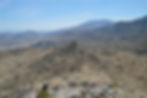
The Art Smith offers remarkable views of Palm Desert and the Little San Bernardino Mountains spanning the valley floor.
The trail continues steadily uphill as it snakes through the desert landscape.

There are several palm oases along the trail, each showing varying levels of stress. The first group of California desert fan palms appeared to be struggling, possibly due to water scarcity, high temperatures, or disease. It's possible that changes in groundwater flow, caused by shifts in the underlying bedrock, have moved away from the palms. Unlike most desert plants, palms have not adapted to survive in hot and arid conditions. Instead of having deep roots that search for hidden moisture, their roots are relatively shallow, reaching only 8-12 feet deep. They exist because they are confined to areas where earthquake faults provide a continuous supply of groundwater to or near the surface.

This stand was doing well judging by the condition of the palm crowns. The most likely reason for gaps in the palm fronds is the wind storms that frequently occur in this part of the Sonoran Desert.

Despite challenges faced by the palms, the desert scrub plant community was flourishing all along the trail including this blooming beaver tail cactus,

this flowering barrel cactus and

this odd shaped barrel cactus.

While small common side-blotched lizards were busy scurrying along the trail, this well camouflaged chuckwalla was focused on sunning itself.

Even from a distance, the third palm oasis appeared to be in excellent health.

The California fan palms are the only palm species native to the western United States. Although often confused with trees, palms are actually 'monocots,' which makes them part of the grass family. They can reach heights of up to 59 feet and have a width of 10-20 feet, with a lifespan between 80 and 250 years. A unique feature of these palms in California is that their fronds, once dead, stay attached and form a wide skirt around the trunk.

Part 2: Off-Trail Hike Across Open Desert
Having hiked for an hour and a half, I arrived at Mile 3 and left the Art Smith trail to begin an off-trail ascent toward the summit. It was the moment to challenge my route-finding and navigation skills, but first, I took one last glance at the well-maintained Art Smith before venturing into the open desert.

After studying various approaches others have used to climb Haystack, I found myself looking directly at the mountain's profile and needing to choose my route. My strategy was to keep to the left of the ravine dividing rib #1 from rib #2, proceed as directly as possible up rib #1, and then move west along the edge of the ravine wall to reach the summit.

The first challenge I encountered was maneuvering over rock piles that obstructed the path to the base of Haystack. It was no more than a Class 2 rock scramble but it was more difficult than it appears in this photo.

Getting closer.

After hiking for almost 3 hours and logging over 4 miles, I had gained 1,800+ ft in elevation. Ahead of me was the next obstacle, while behind me was the beautiful Coachella Valley.

It took just 35 minutes to complete the rock scramble and arrive at the foot of Haystack.

Part 3: Off-Trail to the Summit
Here is where I went wrong. I overshot the ridge I intended to climb and ended up on the other side. Instead of retracing my steps, I decided to continue along a new path to the central ridge leading to the peak. This choice added extra distance, and the new route was steep and littered with loose gravel, which significantly slowed my progress. These conditions were typical of what I encountered at this point.

Perhaps my lack of experience in route finding was evident. This cropped image from my hiking app highlights (blue circled area) the mistake I made and the effort to get back on track. The red line on the left indicates the mistake I made by overshooting the ridge and trekking along a neighboring one. While the red line on the right represents my descent from the peak. FYI, the red line terminates top left of center at the summit.

After reaching the ridge, I was able to look into the ravine that runs alongside the ridge trail leading to the summit.

Along the ridge trail, the rugged landscape of Haystack Mountain became fully visible. The trail includes four peaklets on the way to the summit. According to the US National Park Service, a peaklet is a small elevation that branches off from the main ridge or peak. Here is a close-up photo of peaklet #1.
After climbing further up the ridge, I snapped this photo that showcases three of the 'peaklets' along this part of the trail.

From this vantage point on peaklet #3, I thought I could see Haystack summit. After trekking for nearly 3.5 hours and gaining over 2,280 ft in elevation, it seemed like a logical conclusion.

Although it was mostly a Class 2 scramble, there were a few spots bordering on Class 3.

And just like that the wind was taken out of my sails—a false summit. The true peak lay just beyond the next rise.

A female collared lizard accompanied me on the final part of the trail. These reptiles, identified by two black bands around their necks, can grow up to 10 inches long. Interesting fact: collared lizards are among the few lizard species capable of running solely on their hind legs.

What a sight for sore eyes, the summit cairn. Although Haystack, at just 3,808 feet above sea level, is overshadowed by the towering peaks within the National Monument, this doesn't lessen the satisfaction of finishing the hike.

I spent about 40 minutes at the summit, surrounded in every direction by the vast expanse of desert and mountains. It’s not often you the chance to experience solitude on a summit so that made the time all that more special.

These gloves proved to be very useful so I gave them a prominent role in this photo of the US Army Corps of Engineering reference mark.

Here is the view looking south from the peak.

To the south, the central Santa Rosa Mountains feature Mount Martinez (left of center) at an elevation of 6,562 feet, towering over the smaller peaks.

Part 4: The Slow Descent
Shortly after 1:30 pm I began the return journey. I was not looking forward to the descent down the cactus covered and ...

… rocky, loose gravel ridge trail.

Because of the difficult terrain, I was constantly scanning the area in front of me. Perhaps that’s why I spotted so many lizards during this hike. It's not uncommon to see a chuckwalla or collared lizard, but coming across a rosy boa snake, that's a different story.
When I placed my hand on a rock to steady myself, I noticed something slithering away. I enhanced this photo to emphasize the desert rosy boa nestled between the granite boulders. While these snakes aren't currently listed as endangered, spotting one is rare because they are nocturnal hunters and spend most of their lives hidden under rocks and in crevices to avoid extreme heat and predators. A possible reason for this sighting could be that spring is their breeding season, during which they venture out from their rock piles to find mates.

Everything about these snakes is small and slow. Desert rosy boas typically only grow to lengths of 17-44 inches and have a body diameter about the size of golf ball. They’re among the slowest-moving snakes in the world. Desert rosy boas are unable to pursue prey and must either wait in ambush or stalk their meals. When a meal is within reach, usually a few inches, a desert rosy boa strikes with surprising speed and accuracy. Prey is secured with tiny rows of needle-sharp teeth, then suffocated through constriction. With a slow metabolism they can go extended periods of time (1-2 weeks) without eating so they can wait until just the right moment to strike prey such as small mammals, birds, and occasionally lizards.

The excitement of sighting the desert rosy boa was quickly replaced with a ‘how the hell did this happen’ moment. Despite being extremely careful in my foot placement, I inadvertently stepped on what I believed to be stable ground, only to end up flat on my back, sliding down the hilly terrain. I slid for about 6-8 feet and luckily avoided a direct cactus strike but my arm did scrape against a desert agave. Desert agave have gray-green leaves with sharp spines along the edges and at the tips.

Luckily, the cuts were not deep, and after a few minutes of first aid, I was back on the trail. The photo on the right was taken after I returned home and cleaned the cuts more thoroughly.


Approximately 80 minutes after departing from the summit, I arrived back at the flat desert floor at the base of the mountain.

Once I returned to the open desert floor, I could compare my 'planned' route to my 'actual path' up and down Haystack Mountain. The planned route was indicated by the red line. I missed the 'red' starting point and decided not to backtrack, so I chose the green path for my ascent. During the descent, I initially followed the red planned route but later switched to the yellow route further south (right) due to concerns about the steep incline. Overall, I'm pleased with my first experience in route finding and navigation. I'll definitely aim to improve, but it was a good start.

The path leading back to the Art Smith Trail was dotted with unusual rock formations. With the setting sun, the harsh afternoon shadows weren't a problem taking photos.


After trekking 6.6 miles over approximately 6.5 hours, I returned to the Art Smith trail. It was time for my mind to relax and settle into a familiar and leisurely pace on this trail I've hiked numerous times over the years.

This 'dinosaur' rock formation is always a favorite sight on the Art Smith trail.

Near the end of the hike, I finally managed to photograph a common side-blotched lizard basking on a rock. This species is native to the arid areas of the western United States and northern Mexico. The lizard is probably male due to the blue spots along its spine. An interesting fact about common side-blotched lizards is that their tails serve as a defense mechanism against predators—they can survive without a tail, allowing them to escape after being caught. This particular lizard has successfully kept its tail intact.

Before I realized it, the trailhead appeared, marking the end of a long day.

Conclusion: Was it Worth the Effort
Hiking and conquering Haystack Mountain in the Santa Rosa and San Jacinto Mountains National Monument was a fantastic adventure. While this mountain wasn't initially on my 'bucket list', it's a welcome addition.
Many people frequently describe a location or activity as 'off-the-beaten path' or a 'hidden gem,' but these expressions genuinely capture this hiking experience. This trail features difficult terrain, off-trail hiking, stunning views, and the tranquility of having a mountain entirely to yourself. It's an incredible adventure that's definitely worth the effort. Share it with everyone.