Adventures Along the Columbia River Gorge
- Jul 14, 2021
- 5 min read
Updated: Apr 30, 2025
Spending time in the Columbia River Gorge was a great wrap up to our Washington and Oregon travel adventures. We had a fun chasing waterfalls and driving along the gorge in both directions. Click here to navigate to the 'Chasing Waterfalls in Oregon' blog.
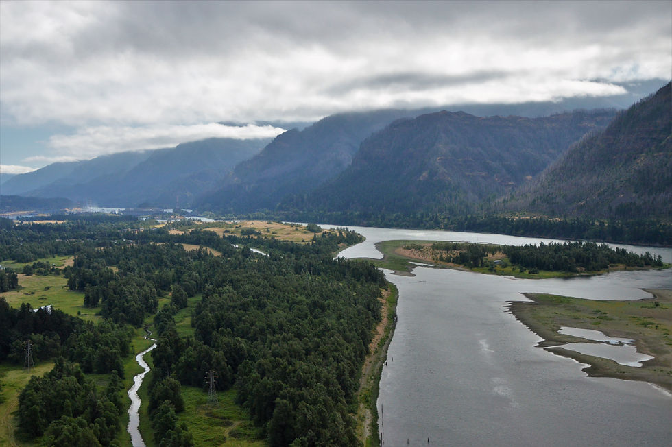
The Columbia River Gorge is a canyon carved by the Columbia River, extending for more than 80 miles. The formation of the gorge started between 17 and 12 million years ago. The gorge's history is marked by two significant floods.

The initial flood took place between 17 million and 6 million years ago. Around 17 million years ago, lava started to erupt from large vents in the Earth's crust at the Washington/Oregon/Idaho border and moved westward along the Columbia River, reaching the ocean. These flows persisted until approximately 6 million years ago. By the end of this period, lava flows had spread over more than 105,000 square miles, encompassing areas in five states.

The overall impact was astounding. When the eruptions finally stopped, a significant portion of the Columbia Basin was covered with a basalt rock layer at least one mile thick. The lava that flowed for millions of years through the river basin shaped the foothills and mountains on both sides of the Columbia River.

The second significant flood was caused by water rather than lava. Toward the end of the last Ice Age, between 18,000 and 12,000 years ago, glacial meltwater accumulated behind ice dams, forming Lake Missoula, which extended hundreds of miles into Montana. This enormous lake spanned over 200 miles in width and was half a mile deep. Eventually, the ice dam broke, leading to what might be the most significant floods in world history. It is estimated that the lake emptied in just a few days, unleashing a wall of water hundreds of feet high, rushing downstream at 65 miles per hour, with ten times the volume of all the world's rivers today.
While the floods did not significantly alter the river's course, they did shape the Gorge. Torrential waters, reaching heights of over 800 feet in certain areas, removed all sediment in their path and carved through the fragile and eroded layers of basalt. This process occurred more than 40 times over a span of 2,500 years, transforming the Gorge from a V-shaped river valley into a deep U-shaped valley with nearly vertical basalt walls and mountains rising from the river's edge.
All of lava and water flows have left behind the magnificent Columbia River Gorge that we see today.

Beyond its natural beauty, the distinctive geography of the Columbia River Gorge renders it one of the most reliably windy places globally. These constant strong winds have also established the gorge as one of the top windsurfing destinations in the world.

Windsurfing conditions are best during the summer when large temperature gradients between the east and the west ends of the gorge drive westerly winds.

The combination of westerly winds and easterly river currents provide excellent windsurfing conditions.

Whitewater rafting is another favored outdoor activity in the Gorge area. Whether you seek a calm scenic journey or an adrenaline-pumping adventure, rafting in the Gorge is an experience you shouldn't overlook.
We opted for Wet Plant Whitewater for our rafting adventure in White Salmon, Washington. We selected this company because they access the White Salmon River from an upstream entry point, situated 2 miles above the usual public launch site that most other companies use. These additional 2 miles offer more challenging class III/IV rapids and some of the most breathtaking canyon scenery along the river.
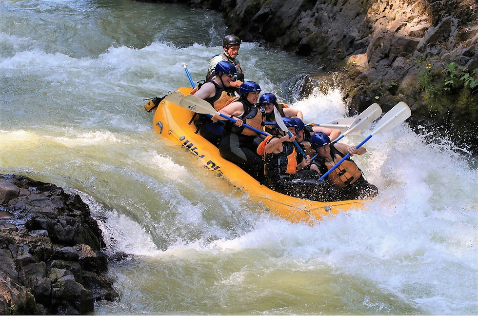
Fed from the glaciers of the majestic Mt. Adams and aquifers beneath surrounding orchards, the river water runs crystal clear all year long. The White Salmon River was once a huge, long lava tube. The roof of the tube has collapsed and the river runs now runs through narrow, volcanic basalt canyons with towering cliffs on both sides.
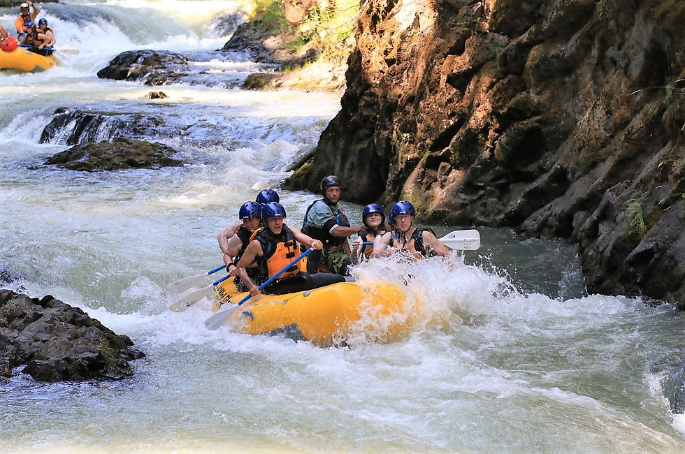
We don't have many pictures because it's not exactly a photo opportunity when you're paddling and holding on while navigating over, around, and through the rapids. However, Wet Planet photographers managed to capture these fantastic shots. The 8-mile rafting journey concludes with an optional 12-foot vertical drop over Husum Falls. Here's a view of the falls from a nearby bridge. From this angle, Husum doesn't appear that large.

Husum Falls is considered the fourth highest waterfall in the United States that is commercially navigated. From our boat, two individuals chose to exit the raft and not tackle the falls. We dropped them off, and our guide reviewed the instructions he would provide as we neared the falls. After a few brief practice runs, we set off, and the guide steered the raft to ensure the 'best experience.' According to our guide, we hit the line precisely as he intended.

With our feet secured under the seats or holders and our hands gripping the ropes on the sides, we approached the falls. Sitting at the front, we experienced the strange sensation of floating momentarily before gravity pulled us down like a rock.

We attempted to hold our breath before being completely submerged, but we were only somewhat successful.

If we maintained our course, the hydraulics of the falls would push the raft upward. However, if we approached it incorrectly, the raft could get caught on the boulders and throw everyone out.

Success!
There is a saying among the guides that goes something like this. "I’m going to tell you about and prepare for every possible outcome, but I plan on this going so perfect that it will look easy."

The look on everyone's faces ... just a bit of an adrenaline rush.

A great ending to a fun day on the White Salmon River.

Before leaving the Gorge the next morning, we decided to do a quick hike of Beacon Rock, an 848-foot basalt volcanic plug located on the north shore of the Columbia River. This rock consists of the solidified magma that once formed the core of a small cinder cone. The rest of the mountain was eroded by massive ice age floods that swept down the river. The United States Geological Survey recently estimated the age of this volcano to be around 57,000 years old.
In 1904, Charles Ladd, an admirer, bought the rock to stop the Army Corps of Engineers from blasting it apart for use in a jetty along the river.

Biddle and a companion constructed an impressive network of trails, ramps, and stairs on the steep slopes of the rock. This intricate trail system was developed between 1915 and 1918. What these two men accomplished in just three years remains intact today. Now, ascending to the top of Beacon Rock involves navigating the narrow trail through 54 switchbacks.

Unfortunately, we had heavy morning fog so our views were cloaked in a layer of clouds.
A quick selfie and then a drive to Portland and an end to our Oregon trip.


First time I ever heard of windsurfing on a river. But I guess it makes sense with everything being bigger and wilder in the U.S. Here in the UK, which I know you've visited, even the biggest rivers wouldn't be wide enough for serious windsurfing, especially since they are so crowded towards the estuaries. Kudos to you for that white water rafting trip. Not surprised to hear two people left before the waterfalls. The pictures show what an extreme adventure you pulled off there and lived to tell the story. Beacon Rock looks fun, too.
Wow! I think I would have gotten off the raft before that waterfall, for sure! I admire you for sticking it out. I actually think the view you took from Beacon Rock with the clouds is gorgeous. I really want to visit Oregon, and I'll be sure to keep this itinerary in mind when I do.