Chasing Waterfalls Along the Columbia River Gorge, OR
- Jul 13, 2021
- 5 min read
Updated: Oct 16, 2025
Waterfalls included in this adventure:
Multnomah Falls
Dutchman Falls
Wiesendanger Falls
Ecola Falls
Fairy Falls
Wahkeena Falls
Lower Latourell Falls
Upper Latourell Fall
This post includes two waterfall hikes. The data listed below combines details from both hikes.
Hike Distance: 8.5 miles
Elevation Gain: 2,068 feet
TrailsNH Hiking Difficulty Calculator: 187 – Strenuous

Click here to navigate to the TrailsNH website for a description of the hiking difficulty calculator
Lets Start Hiking Multnomah to Wahkeena Trail Loop
Distance: 6.2 miles
What better introduction to hiking in the Columbia River Gorge than completing the Multnomah to Wahkeena Trail Loop. There are 6 officially named waterfalls on this hike as well as countless streams and intermittent falls.
We completed the trail in a counterclockwise direction starting at Multnomah Falls, the granddaddy of all the falls in Oregon. As you approach the falls, it's easy to see why this is the most visited natural recreation site in the entire Pacific Northwest.
Multnomah Falls is split in two tiers. The lower tier drops 69 feet into a large pool at the base of the observation deck. The Benson Footbridge situated 105 above the pool straddles the area between the two tiers and provides visitors with incredible views. The footbridge was named for Simon Benson, a prominent Portland businessman who owned the falls in the early part of the 1900s. Before his death, Benson gave Multnomah Falls to the City of Portland, which later transferred ownership to the USDA Forest Service.

The upper tier plunges 542 feet for a combined drop of over 620 feet. The two tier structure is due to a zone of more easily eroded basalt at the base of the upper falls.
On Labor Day in September 1995, a 400-ton boulder (the size of a school bus) that was loosened by erosion fell 225 feet from the face of the upper falls into the cascade pool. People standing on the bridge located 95 feet above the pool were sprayed with water and rock debris that shot hundreds of feet in the air. Over 20 people were treated for a variety of injuries. Rock falls at the falls continue, presenting challenges for the US Forest Service.

After enjoying the views and taking plenty of photos, we continued following the trail up a series of switchbacks.
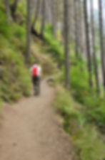
It was great to see that we were getting closer.

Ultimately, the trail led to an observation deck that ...

... overlooked the point where water plunges 540 feet down the basalt cliff-face. The Benson Footbridge is visible in the upper right quadrant of this photo. It was quite a different view from up here.

Time to continue chasing more waterfalls.

First up was Dutchman Falls, a trio of small falls that are close enough to be grouped together. They weren't very impressive and to be honest we would have walked by them if they hadn't been included in the trail description.

A short distance later, we passed through Dutchman Tunnel. It's really not a tunnel but for some reason the name has stuck.

Ages ago when Multnomah Creek was a raging river and not a babbling creek, the current was strong enough to slice through the bottom layer of the basalt walls of the gorge and create this overhang.
At about the 2-mile mark of the trail, we encountered Wiesendanger Falls where the Multnomah Creek drops 55 feet over a lip into a broad gorge. We needed to scramble over rocks, fallen trees, and other debris to reach the base of the falls but it was worth the effort.


In less than 15 minutes, we were passing Ecola Falls. Similar in size to Wiesendanger Falls, Ecola drops 55-feet as water kisses the surface of the underlying cliff face. We didn't trying to access the base of these falls since it involved a steep, crumbly scramble down the side of the canyon. However, photos like this taken from the plunge pool show a different view that most people don’t get a chance to see.

After Ecola Falls the trail continued to follow the Multnomah Creek but began to rise out of the basalt lined gorge and into a drier, tall forest. Blackened tree trunks were a reminder of the 2017 Eagle Creek fire that burned over 48,000 acres within the Columbia River Gorge.

There is no doubt the Eagle Creek Fire was a serious and deadly event but fires are as important to the health and resilience of forests in the Pacific Northwest as rain and soil. While heavily burned areas may initially be ugly to the human eye, they create openings which enable diverse vegetation to grow, which in turn provides fruit, seeds, and nectar for wildlife to thrive.

Bramble bush

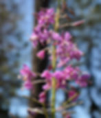
Fireweeds
The “early seral” forest that returns a few years after the fire is among the most vibrant and important wildlife habitat in the Pacific Northwest. Fire is so beneficial to wildlife that the US Fish and Wildlife Service has created fact sheets to educate the public about its importance.
Believe it or not, the trail was easy to follow despite the plant growth along the sides.

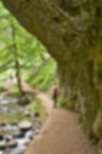
Occasionally, the trail broke through the trees and provided amazing views 1,500 feet above the Columbia River.

We were never far from the sound of water tumbling over rocks as it makes its way to the river. There is nothing like that sound.

Fairy Falls came into view after hiking for over 2 miles without seeing any waterfalls since Ecola Falls. Fairy Falls is a classic veil or fan fall dropping 20 feet over moss-covered rocks. What it lacks in height it more than makes up for in elegance.

We found a medium-sized harmless garter snake hanging out around the waterfall.

Wahkeena Fall was the last falls along the loop trail. At 242-feet high, it is one of the tallest waterfalls in the area but the tiered structure and the twisted path the water takes through the chute hides much of its overall length.


On the home stretch toward the parking area at Multnomah Falls. There were some great examples of the basalt walls along the loop trail. Basalt is the most common rock on Earth’s surface. It is an extrusive igneous rock that is produced when magma exits and cools above or very near the surface. These are the rocks that form at erupting volcanoes and oozing fissures; there is plenty of basalt around here. The Columbia River basalt lava flows cover more than 81,000 square miles including parts of eastern Oregon, Washington, and western Idaho. In some areas of the Columbia River basin, the lava flows are estimated to be more than 13,000 feet thick.

Under certain conditions, when lava cools to form basalt it contracts as it cools too rapidly and cracks. Glassy columns like these crystallize out, with pentagonal, hexagonal, and sometimes heptagonal shapes all precipitating. For more information about these incredible basalt flows, check out the Fun Along the Columbia River Gorge blog.

Lets Start Hiking Latourell Falls Loop Trail
Distance: 2.3 miles
Even after 6+ miles and 6 waterfalls, we were wiling to check out one more waterfall. We made the short drive to Guy W Talbot State Park to complete the Latourell Falls Loop Trail.
Lower Latourell Falls is a beautiful 225-foot single drop waterfall that can be seen right from the trailhead along Historic Columbia River Highway. Farther up the canyon is Upper Latourell Falls, which is 134 feet tall, sliding down a basalt overhang before twisting to a freefalling plunge


It’s only short walk up the canyon to Upper Latourell Falls (overall length of 249 feet). The top tier of the falls slides down a steep rock face of basalt. The water then drops from an overhang, falling to a plunge pool on the the canyon floor.

Latourell is unique among the best-known Columbia Gorge waterfalls, in the way that it drops straight down from an overhanging basalt cliff. Most of falls, even Multnomah Falls, tumble to some degree.
Getting to walk behind the falls was a great way to end our "chasing waterfalls in the Columbia River Gorge".
