Grand Canyon NP: No Water and All Wonder - the South Kaibab Trail
- Jun 15, 2011
- 13 min read
A Few Words about Grand Canyon National Park
Grand Canyon National Park protects one of the world’s most complete and accessible records of Earth history. Nowhere else does a single landscape expose nearly two billion years of geology in such clear, stacked layers. The canyon’s walls reveal ancient sea beds, desert dunes, river floodplains, and deep crystalline basement rock—each preserved as erosion by the Colorado River and its tributaries carved downward and outward through the Colorado Plateau.
An estimated 6 million people visit the GCNP each year, making it the second most popular national park following just behind the Great Smoky Mountains of North Carolina and Tennessee. Some fun facts about the Grand Canyon:
The Grand Canyon is bigger than the state of Rhode Island. The Grand Canyon is a mile deep, 277 miles long and 18 miles wide. While the park doesn’t include the entire canyon, it does measure in at a whopping 1,904 square miles in total. In comparison, Rhode Island is around 1,212 square miles.
Despite being the most famous, the Grand Canyon is not actually the world’s deepest canyon. Depending on how the depth of the gorge is measured, the Arizona landmark actually comes behind the Cotahuasi Canyon in Peru and the Kali Gandaki Gorge in Nepal.
The Grand Canyon offers one of the most visible examples of a worldwide geological phenomenon known as the Great Unconformity, in which 250 million-year-old rock strata lie back-to-back with 1.2 billion-year-old rocks. What happened during the hundreds of millions of years between remains largely a mystery.
Why Hike the South Kaibab Trail
Many hikers choose the South Kaibab Trail because it delivers the Grand Canyon immediately and without compromise. Steep and strenuous, it is considered the best and also the least traveled of the two maintained Grand Canyon. Unlike other corridor trails that ease you in through forested switchbacks or shaded side canyons, South Kaibab steps off the rim and stays exposed, riding narrow ridgelines where the canyon opens in all directions. From the first mile, the views are constant and expansive—there’s no waiting to get to the scenery.
Choose South Kaibab if you want a trail where the canyon never disappears—where geology isn’t just explained on signs, but seen, felt, and measured with every step downward.
Hike Distance: 10 miles (past the Train Wreck rock outcropping)
Elevation Gain: 3,640 feet
TrailsNH Hiking Difficulty Calculator: 270 – Challenging

Click here to navigate to the TrailsNH website for a description of the hiking difficulty calculator
Let's Start Hiking
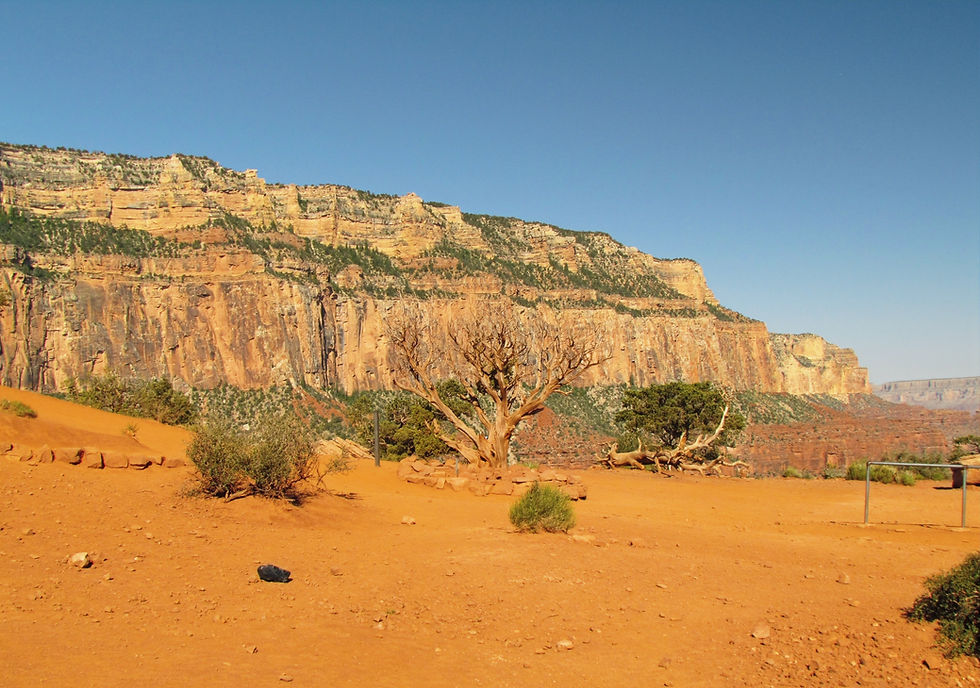
We arrived at the trail head about 7:30am and made a final pit stop. There is drinking water at the start and at the river but not in between. We stocked up on water, our camel backs were full and we carried a few extra water bottles.

The beginning of the trail was in shade, but we were not counting on it lasting very long

When the Grand Canyon became a National Park in 1919, the popular trails like Bright Angel were privately owned and charged a toll. The Parks Service tried to purchase Bright Angel, but determined it was cheaper to build a new trail, the South Kaibab. Right from the start, it's all about 'going down'. The trail immediately plummets down a series of steep switchbacks.

Very quickly the switchbacks opened up to breathtaking canyon views in every direction.

The first ray of soft morning sunlight illuminated the canyon in magnificent detail.

A quick descent meant looking up to keep the South Rim in sight.

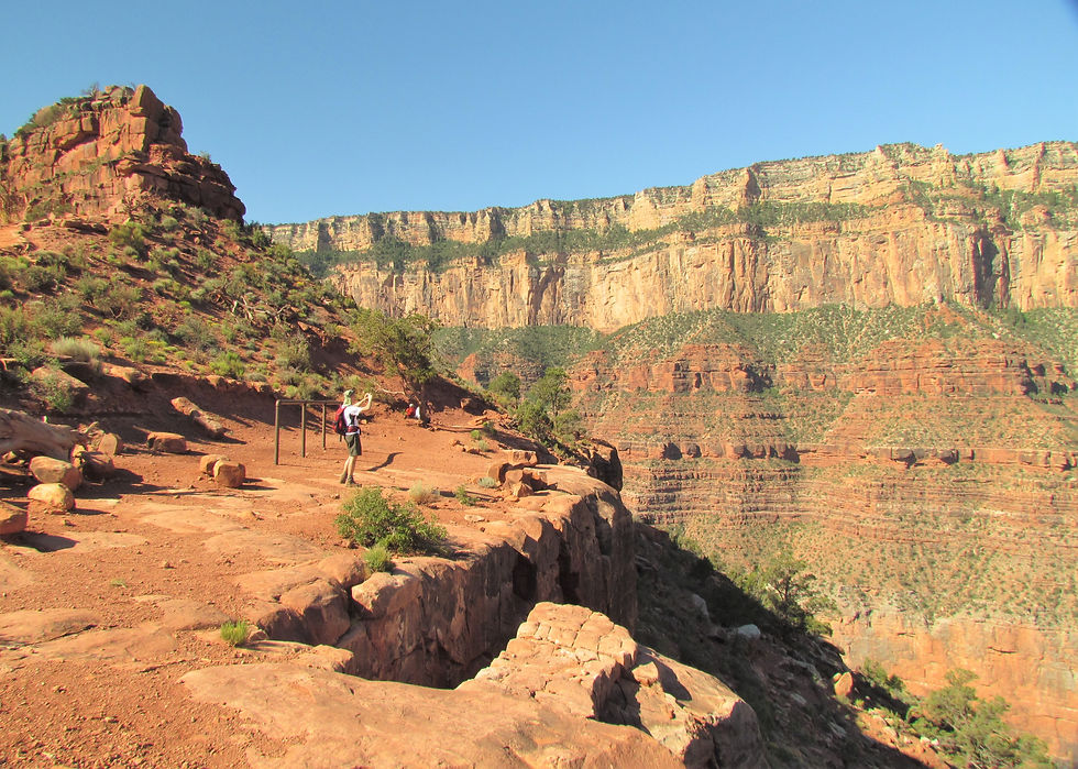
After a 0.9-mile hike that included a descent of over 600 feet, we arrived at the
Ooh Aah Point vista. This adventure is fantastic even if you aren't an avid hikers. If you can meet the physical demands, start the hike early in the morning to benefit from the shade and enjoy the great, haze-free views of the inner canyon.


Dave has such a sense of direction, I wasn't sure which way to go from here. It's another 0.6 miles to the next way-point...Cedar Ridge.

When the trail was being constructed in 1924, workers used explosives to blast through rock ledges, to deal with the drastic elevation changes and uneven topography.


Despite scorching temperatures. desert wildflowers grew along the side of the trail and in rock crevasses.


As we ventured deeper into the hike, the canyon opened up with ever greater vistas.

Our next waypoint was Cedar Crest and O'Neill Butte (right of center). From the picture below, you can see the trail descending along the ridge's spine; judging distances in such wide-open spaces is difficult.


He still had super powers at this point in the hike and there were no sweat stains yet. The temperatures were still hovering in the 70s.

As we approached Cedar Ridge, a scattering of cedar trees dotted the hillside.

After an hour of hiking, we arrived at Cedar Ridge, having trekked 1.5 miles and descended over 900 feet.

If you review the A QUICK LESSON ON GEOLOGY OF THE GRAND CANYON section at the end of this blog, we were located at the transition point between rock formations #4 and #5.

It was a great sensation looking up at the South Rim and seeing how far we'd hiked. You can see the trail as it wraps around the ridge. The small building left of center, contains pit toilets but no drinking water. Once past Cedar Ridge, day hikers were a rare sight.

From the ridge it's a 0.5 miles to O'Neill Butte.

O’Neill Butte is a prominent sandstone summit admired by every hiker who passes it. Not surprisingly, O'Neill is one of the more highly photographed features in the park. If you know where to look, it's also visible from the South Rim.

Despite its appearance in pictures, the butte was enormous. The presence of two hikers near its base provides the a true sense of its immense size. It was incredible to think that we were walking on rock layers and formations that were over 300 million years old.

The trail hugged the base of the butte.

In the distance were yet another set of switchbacks (far right of center).

There's a long traverse from O'Neill Butte to Skeleton Point; a well timed break from the constant downhill.

Looking back at O'Neill Butte and the South Rim.

We had to remind ourselves to occasionally look back at the stunning views of the South Rim.

This section of the trail featured an increasingly green desert scrub landscape populated by grasses, low shrubs and small flowering desert plants.

Look at the size of this desert agave!

After hiking three miles and descending over 2,000 feet from the rim, we reached Skeleton Point.

The Colorado River, churning 3,000 feet below, appeared for the first time during our hike.
The landscape here is so immense. With no other hikers and only the faint sound of the Colorado it felt very 'isolated and remote'. With views like these, it's hard to accept that the average park visitor never leaves the Canyon Village. They roll up in their rental car, park at a vista point, stroll to the guardrail to look around, then browse the gift shops. The park estimates that the average visit lasts less than four hours. What a shame!

From Skeleton Point, the trail drops straight over the edge of the Redwall Limestone cliffs. If you review the A QUICK LESSON ON GEOLOGY OF THE GRAND CANYON section at the end of this blog, we were located at the transition point between rock formations #5 and #6.
The descent to the Tonto Platform, involving a swift 500-foot drop across 20 switchbacks at the foot of the cliffs, was the most intense section of the trail. We were dreading the climb back up, knowing the descent had been difficult.
What's the difference between a plateau and a platform: a plateau is a prominent 'tableland' that is higher than its surroundings, whereas a platform is a stable base of ancient rock covered by flat sedimentary layers, which may or may not be topographically elevated.

Fortunately, there was a lot of eye-candy to take our mind off the work at hand. This was the view as we started the switchbacks.

The scenery on South Kaibab never gets old. We could now see into the inner gorge; all of those hours spent training on the gym stair master had been worth the effort. The Colorado River was down there somewhere.

At times the switchbacks clung to the sides of the cliff.

We also got our first smell of a mule train coming up from the Phantom Ranch.

To safely let mules pass, the rule is to move to the higher side of the trail and away from the edge.

We were still making good progress despite the temperature rising steadily.

Looking straight ahead, we could see our progress as the Redwall Limestone cliffs rose above us.

We came across this sign on the switchbacks and thought...holy sh*t, we haven't even reached the Tonto Platform and if we turn around now we have to hike 3.5 miles uphill and gain 2,760 feet in elevation. We paused took a deep breath. We had planned for this moment, trained well, and had plenty of food and water to safely continue hiking.

We took a short break in the only available shade we could find and reapplied sunscreen.

From Skeleton Point, the only hikers we saw were a young couple and they were considerably higher up on the switchbacks.

The end of the switchbacks were in sight but we still a ways to go.

These were the views that keep us going. Finally the switchbacks ended, the trail straightened, and we faced the challenge of a 3-4 foot path that clung to the rock face

Looking back, the cliff doesn't look that high but the cliff face was over 500 feet high.

Approaching the beginning of the Tonto Platform. In A QUICK LESSON ON GEOLOGY OF THE GRAND CANYON section at the end of this blog, we were located at the transition point between rock formations #7 and #8.

We still had a significant distance to go until we reached the end of the Tonto Platform where we could peer directly into the inner gorge of the canyon. The yellow arrow highlights the trail we'd follow as we traversed the platform.

Unlike the previous terrain, the Tonto Platform color varies but it was mostly various shades of green gray and brown. It looked completely different than any of the layers above it.

Our next waypoint was the junction with the Tonto Trail and Tipoff Point. The Tonto Trail runs east-west across the Tonto Platform and connects to Bright Angel Trail, the other trail that lead to Phantom Ranch. If you look closely, you can see the pit toilet building (lower right of center) at Tipoff Point.

By the time we reached the Tonto Trail crossing, we had covered 4.4 miles and descended over 3,200 feet

Another 0.2 miles of trekking and we arrived at Tipoff Point. We took shelter behind the pit toilet building and ate a quick lunch.

A look back at the trail we had followed to arrive to the Tonto Trail crossing. We had been hiking for approximately 3 hours and 45 minutes that included periodic breaks and stops for photos; trekked nearly 4.6 miles and descended over 3,300 feet.

Still looking strong and fresh. At Tipoff Point, the trail begins a descent into the inner gorge. This had been our intended target for today's hike if everything had gone smoothly.

At this point, we began to discuss when to start our return journey. We chose to push past
Tip Off Point, heading for the next cliffs to get a direct view into the inner gorge and the Colorado River. Unfortunately that meant tackling another series of switchbacks.
If you review the A QUICK LESSON ON GEOLOGY OF THE GRAND CANYON section at the end of this blog, we were located at the transition point between rock formations #8 and #9.


We continued trekking toward the distinctive rock outcrop known as Train Wreck.

As we passed Train Wreck, we came across this impressive rock outcrop and continued on. We saw hikers ahead of us on the trail for the first time in a long while.


A short distance later we arrived at a vista that offered sweeping views of the Colorado River and the Canyon. Not only could we see the river but we could hear it as well, churning some 1,200 feet below us.

Nothing prepared us for this moment when we could see the bottom of the Grand Canyon.

The Black Suspension Bridge allows hikers from the South Kaibab to cross the Colorado River and reach the Phantom Ranch campground.

We were looking directly into the inner gorge of the canyon and staring at rock formations that were over 1 billion years old. Also directly in front of us was the geological phenomenon referred to as the Great Unconformity. In an oversimplified explanation, it's where 515-545 million year old rock layers sit directly on top rock layers that that are 1,600 - 1,700 million years old. This unconformity represents ~1.2 billion years of missing rock record. It could represent a time when no rocks were formed, or a time when rocks were formed but then eroded away.
In the picture below, the Great Unconformity exposed in Grand Canyon Tapeats Sandstone (upper center dark narrow band of cliffs) sits directly atop ancient Proterozoic metamorphic rocks commonly called Vishnu Schist or Vishnu Basement Rock (1,600 - 1,700 million years old).
Notice how Tapeats Sandstone, a horizontal rock formation laid down by a shallow sea, differ from the warped and twisted formation of Vishnu Schist. These basement metamorphic rocks were formed when the North American plate collided with an ancient chain of volcanic islands. During this collision, the rocks were pushed down to depths of up to 13 miles below the Earth’s surface. Intense heat and pressure at those depths metamorphosed the sedimentary and volcanic rocks, changing them into schist and gneiss (the dark, angular rocks found in the inner canyon near the river today).
What an amazing site to see up close.

We immediately knew this was the perfect place to end our hike into the Grand Canyon. We had hiked slightly more that 5 miles and descended over 3,600 in 4 hours and 15 minutes. It felt right, we felt confident and ready for the return journey. We had stayed hydrated and still had a good supply of water and food.
What a sense of accomplishment.

After all the pictures were taken, we took a deep breath and began our return to the South Rim. I can tell you, we were both a little anxious as we took those first few steps. Anxious about the challenge we'd face with each step back to the South Rim.

We took advantage of any flat section of trail and walked at a moderate pace.

We stopped whenever we found shade for a quick drink and break from the sun.

Our pace slowed dramatically as we began the slow and steady climb up the Redwall Limestone switchbacks. No way around it; they were a killer.

We had a mini celebration after cresting the cliff face; the worst was behind us. We were still doing well and staying hydrated.
After passing O'Neill Butte, Cedar Ridge and Ooh Aah Point, we were so close to the finish line. Just the steep switchbacks at the start of the trail. With great relief we reached the trailhead in slightly under 3 1/2 hours.


We had very little water left at the end but had managed to stay hydrated throughout the 7 1/2 hour journey. We quickly removed our packs and boots, filled up the extra water bottles we had carried and sat in the shade.

Proud of my red dust Grand Canyon sock mark.

Taking a moment to look back at the Canyon knowing how far we had hiked and 'safely' pushed ourselves for a great Grand Canyon experience.
Choose South Kaibab if you want a trail where the canyon never disappears—where geology isn’t just explained on signs, but seen, felt, and measured with every step downward.

These types of hikes and outdoor experiences would become our trademark for future vacations and adventures.
A QUICK LESSON ON GEOLOGY OF THE GRAND CANYON
The rim of the canyon is covered by a layer about 300 feet thick that's called the Kaibab Formation (#1). It forms an erosion-resistant cap rock that extends down to the beginning of the tree line where the formation begins to slope downward. This light gray to tan colored layer, composed of sedimentary stone (limestone, sandstone, etc.), was formed some 250-270 million years ago. This was a time when Arizona lay near the Equator and a clear, warm sea no more than a couple hundred feet deep covered this region.
The narrow 'sloping' rock layer beneath Kaibab Formation that is covered in scrub/trees is the Toroweap Formation (#2). This 255-273 million year old layer is composed of much the same materials as the Kaibab Formation.
The third prominent layer is the Coconino Sandstone (#3) rock layer which is often referred to as the 'bath tub ring of the canyon' since it stands out in sharp contrast to the red layers below. This prominent 350-foot cliff forming layer is about 260-275 million years old is composed of pure quartz sand which are basically petrified sand dunes. This wind-blown dune desert stretched from present-day Arizona all the way to Canada.

Directly below the Coconino Sandstone (#3) cliff layer is the Hermit Formation (#4). This 265-280 million year old formation is composed of soft, easily eroded shale. Because this layer is not as hard as the Kaibab layer or the Coconino Sandstone it forms a slope between the two cliffs. Although it ranges from 100-900 ft in thickness, in many places it can be easily distinguished because it’s so covered with plants/scrub or silt runoff from higher levels. The rich red color of the Hermit Formation (#4) and the Supai Formation (#5) is a sure indication that the sediment was formed in an environment with lots of oxygen to rust the iron in the mud. Running water is one of the best ways to provide this oxygen to the sediment, so rivers, floodplains and tidal flats often deposit sediment that will turn that rich red color.
The fifth formation is the extensive layered slopes and thin cliff of the Supai Formation (#5). This 285-320 million year and 1,000 foot thick layer is mostly red siltstone and sandstone. The Supai layer dominates views along the trail. Part of Grand Canyon’s picturesque value lies in the colorful red layers that make up parts of the canyon walls. The minerals that make up the red rock came from rocks that were rich in iron. As these rock eroded, the iron was oxidized to make rust (iron oxide). The red iron oxide was then deposited along with other sediment to make the red rock layer.
After the Supai layer are the tall vertical steep cliff of the Redwall Limestone Formation (#6). This 340 million years old, 500 feet thick was deposited when the regions was covered by a shallow inland sea. The cliff is named 'Redwall' because it's surface is stained red by the upper layers. As these softer layer erode the red sediment runs down and stains the walls. If you break off the 'red layer' you'd find the true color of the limestone is a bluish-grey color.

Below the Redwall Limestone (#6) formation is the 1,250 feet thick Tonto Group. When the ocean started to return to the area 550 million years ago in the Cambrian, it began to deposit the three formations of the Tonto Group as the shoreline moved eastward: Muav Limestone (#7); Bright Angel Shale (#8); and Tapeats Sandstone (#9).
Muav Limestone (#7) averages 515 million years old. It is composed of gray thin-bedded limestone that was deposited further offshore as calcium carbonate precipitate. The Muav is a cliff-former, 250 to 375 feet thick.
Bright Angel Shale (#8) averages 530 million years old. The Bright Angel Shale is easily identified for two reasons. Its soft-greenish color stands out against the browns, reds, and whites of neighboring rock units. Secondly, it has a slope-forming character against mostly cliff-forming resistant rocks.
Tapeats Sandstone (#9) is an average of 545 million years old. This formation is made of cliff-derived medium- to coarse-grained sand and conglomerate that was deposited on an ancient shore. Today it is a cliff-former, 250 to 300 feet thick.

The Great Unconformity exposed in Grand Canyon Tapeats Sandstone (#9: upper center dark narrow band of cliffs) sits directly atop ancient Proterozoic metamorphic rocks commonly called Vishnu Schist or Vishnu Basement Rock (#10: 1,600 - 1,700 million years old).


Comments