Incredible Time Spent in Lewis & Harris: Outer Hebrides
- Aug 19, 2019
- 13 min read
Updated: Apr 20, 2025
Our 4-night stay on Lewis and Harris was planned as a relaxing time for us to experience life in the Outer Hebrides. The Western Isles, or Na h-Eileanan an Iar in Gaelic - also known as the Outer Hebrides - are a 130-mile-long string of islands lying off the northwest coast of Scotland. There are 119 islands in total of which only 15 are inhabited. Technically one landmass, but split into two islands, Lewis and Harris lie at the top of the Outer Hebrides off Scotland's west coast. The Narrow isthmus connecting the two landmasses is barely visible in the picture below.
The Western Isles have been occupied for over 6000 years. Life began to change in the 800s when Viking raids on the islands began. The Norse influence and strength was so great that by 1098 Edgar, King of Scotland, formally signed the islands over to Magnus III of Norway. The Hebrides became part of the Kingdom of the Isles whose rulers were vassals of the King of Norway. It wasn't until 1266 that Norway yielded possession of the islands back to the Kingdom of Scotland.
The Gaelic language is testament to the strong Celtic heritage of the Outer Hebrides. First brought to the islands by Celts from Ireland, their language blended with the Old Norse, slowly evolving into the Gaelic spoken on the isles today, slightly different from the Irish Gaelic across the water. Today it's estimated that 60% of the population are Gaelic speakers.
Religion is a cornerstone of life in the Hebrides. Even today, most of the islands observe the Sunday Sabbath - day of rest. Shops were not open when we arrived bu we planned ahead and brought food over in the car.
The picture below shows the Isle of Skye in the right middle and the Outer Hebrides in the center. Lewis an Harris is the large island in the middle to top right section of the picture.

Locations/activities covered in the blog:
Luskentyre and Scarista Beaches
Golden Road of Harris
St. Clement's Church
Callanish Standing Stones
Great Bernara Hike
Gearrannan Blackhouse Village
Butt of Lewis Lighthouse
Dun Carloway Broch
Stornoway
Random drives around the isle
Day 13 Plans
We took the Calmac ferry from Uig on the western coast of Skye to Tarbert located on the Isle of Harris. The total travel time was 1 3/4 hours. Since we were bringing the car, we had bought our tickets months before when our itinerary was finalized. Uig is a small village best known as a ferry port for travel to the Outer Hebrides. The weather wasn't looking great for our travels with strong winds and occasional rain, but luckily we had more xxx patches for motion sickness. Better safe than sorry.

Our ferry approaching and cars lined up for boarding.


We boarded quickly and in no time we were leaving the Isle of Skye behind us and traveling through Loch Snizort.


Once we were off of the ferry, we began the hour long drive to Carloway, a crofting township on the west coast.
Much of the environment and identity of the Outer Hebrides has been shaped by a strong crofting tradition.
Croftingor tenant farming is the traditional mainstay of the economy and is still widely practiced. The typical croft is just a few acres with a handful of sheep, a cow, and enough crops to supplement the diet and provide a small income.
A crofter is one who has tenure and use of the land typically as a tenant farmer, especially in rural areas.
This was the scenery for the drive to Carloway. It was easy viewing even with a dreary sky.

Our Airbnb Na H-E'Leanan An Lar was incredible. a nice house in a small neighborhood with plenty of room, an updated kitchen, and a small living room with an electric fireplace heater. A great place to cook supper then head to the leather couch and relax reading a Peter May novel. The Outer Hebrides is the setting for many of his books.

The owners requested that we close the gate at the front of the house to avoid waking up to dozens of sheep grazing in the yard.

After unpacking and organizing the kitchen, we went for a short drive to Dalbeg beach in the north of Carloway.


Day 14 Plans
Morning Run
Golden Road of Harris
Luskentyre and Scarista Beaches
St. Clement's Church
Callanish Standing Stones
This was the morning view that greeted us from the kitchen window.

After a great night sleep we were ready for a morning run. Since Dave runs faster and longer than I do, we took off at different times and in opposite directions. We were both treated to amazing scenery.


After a heart breakfast, we began our drive down the A859 to Tarbert and then on to the Golden Road that follows the coastline of Harris.

Luskentyre Beach
Beaches may not be the first thing that comes to mind when you think about Scotland, but the beaches on the west coast of Harris will change that perception. Luskentyre Beach is considered one of the best beaches in Britain and Travel Magazine has also named it among the top beaches in the world.

After a 5-10 minute walk through the dunes we got our first glimpse of the beautiful beach.

Their white sands and clear turquoise waters could easily give islands in the Caribbean a run for the money.

This secluded beach many not be a top sunbathing spot with average high temperature during the summer of 57-61°F, but it's a great place to walk during low tide.

Just enough time for a picture before the showers started.

Scarista Beach
We continued driving on the Golden Road with stunning coastline views the entire way. We stopped at a picnic area above Scarista Beach. It is less well-known that Luskentyre up the coast, but just as spectacular, There were a few brave people taking surfing lessons in water no warmer that 55F.

We followed a path down to the water.

Beautiful sand art on the beach.


We reached St. Clement's Church in the village of Rodel, the southern most point during our travels today. The church is dedicated to St. Clement, the 3rd bishop of Rome (after St. Peter) who was martyred in 90 AD. It is suspected that the church was commissioned and build in the late 15th century by Alasdair 'Crotach' MacLeod of Dunvegan and Harris, 8th Chief of the Clan Macleod.

When Alasdair died in 1547, his body was laid to rest in St. Clement's Church, in a magnificent wall tomb he had built on the south side of the choir in 1528. The tomb is one of the most richly carved wall tombs in Scotland of its period. By choosing to be buried in Harris, Alasdair broke with tradition since previous chiefs of the clan had been buried on the Isle of Iona.

Another more crude tomb in the nave probably belonged to John MacLeod of Minginish 10th Chief of the Clan who died in 1557.

In the graveyard surrounding the church are the burial places of several MacLeod chiefs.


The coastal drive continued to provide amazing views and interesting stopping points. We stopped in the village of Finsbay and found a small road-side stand that sold chocolates. The stand was self serve so you leave money in the mailbox for whatever you purchased. It wasn't until afterwards that we discovered it was the home of the owners of 'Bay of Chocolates', a famous Harris chocolatier.
The Harris coastline is dotted with sheltered coves and rocky bays so there was no problem being entertained during the drive.


As we moved away from the coast, the hills and mountains of Harris took over the landscape. Even though a large percent of the Golden Road was a single track, it had been an enjoyable day driving through this slice of Harris heaven.


Standing Stones of Callanish
As we approached Carloway, we decided to stop at the Standing Stones of Callanish since there was no sign of rain and the crowds at this popular location would have thinned out by early evening.

The Callanish Standing Stones were erected by Neolithic people over 5000 years ago and predate England's Stonehenge site by at least 500 years. The site consists of a stone circle forming a kind of avenue or street.

Dave is standing by the 16 foot central monolith near the center of the stone circle. The largest sides of the stone are almost perfectly oriented to the north and south.

The stones are made of Lewisian gneiss, the name deriving from the Isle of Lewis. Lewisian gneiss is mostly granite-like and are some of the oldest rocks in Europe, dating back 3 billion years.

The exact purpose of the stones has been lost to history. The most prevalent theory, based on recent archaeological excavations, holds that the megaliths acted as some sort of astronomical observatory or a celestial calendar.

Around 1500-1000 BC the complex fell out of use. Being among the stones at dusk without the crowds was a memorable experience but soon it was time to head back to the house for dinner and a night of reading by the fireplace.

Time to settle in with Peter May.

Day 15 Plans
Great Bernara hike
Gearrannan Blackhouse Village
Butt of Lewis Lighthouse
Sunset on the beach
Our day started out early with an 8.1 mile hike on Great Bernera. Click on the link to navigate to the hiking blog.
Gearrannan Blackhouse Village
Huddled on top of a hill facing the Atlantic is a cluster of stone cottages. This cluster of housed was build in the late 1800s. They're the traditional blackhouses that once dotted the Hebridean landscape.

For centuries, Highlanders and their livestock lived in these one-room abodes. The houses, which featured packed earth floors, dry stone walls, and thatched roofs, offered refuge from the wild North Atlantic weather.


A fire in the small central hearth kept the space warm and a divider separated the human inhabitants from their farm animals, which remained huddled at one end of the building.
The torrential rain that was falling made us appreciate the rudimentary living conditions in these houses. Between 1945 and 1965, the other crofts and blackhouses on the Isle of Lewis received running water and electricity. People lived in these houses until the 1970s, when the village's remaining elderly residents moved into more modern homes.

Fortunately, the blackhouses were only a few minutes drive from the house so we quickly got back to the house and dried off. We had planned a quite evening but magically during supper the rain stopped and the sky cleared so we jumped in the car and drove to Port of Ness to capture a sunset on the most northern tip of Lewis at the Butt of Lewis lighthouse. Because we were so far north, sunset was not until 8:59 so we had plenty of time to drive the 28 miles. Looking at this map it's interesting to think that over 2 days we had traveled to the northern tip (Butt of Lewis) and the southern tip (Rodel) on Lewis and Harris.

At the far northern tip of the Isle of Lewis is the Butt of Lewis - the furthest north you can get in the Outer Hebrides and what feels like the edge of the world. If you travel north it's open sea all the way to the Arctic; travel west and the nearest land is Newfoundland in Canada.

The rocks which make up these 80 foot high cliffs are Lewisian Gneiss which formed some 3 billions years ago. They are the oldest rock in Europe and some of the oldest in the world.

This stretch of coastline gets pounded by waves and winds up to 100 mph - the Guinness Book of Records once rated it the windiest place in Britain. But today there was no wind at all. I guess this makes up for the insane wind that we experienced at Neist Point Lighthouse on Skye. Check out this blog if you haven't watched the video.


Butt of Lewis Lighthouse, designed by David Stevenson, was build between 1859 and 1862. The lighthouse stands at 121 feet and the light has a range of 25 miles. Unlike many Scottish lighthouses, this lighthouse was build of red brick. Stevenson said that to use "common brick" here would not be feasible as it would not withstand the exposure to the sea. The station was automated in 1998, one of the last to be converted. Prior to electrification, the lighthouse was first fueled by fish oil from 1862-1869 and paraffin from 1869-1876.

At the lighthouse we spotted a seal basking on a rock just below the cliffs.


Since we still had about an hour before sunset we tried to find a beach west of the the lighthouse to watch the sun set over the ocean. You'd think it would be easy since we were on the tip of the island, but every street we tried dead-ended in a neighborhood without access to the beach. Finally we struck gold and found a trail to a small beach. But of course first we had to walk through a field of grazing sheep ... they're everywhere on the island.


What a way to end the day. Wind, rain, more rain, but when we needed it most we had clear skies

Time to head back to the house and read more of the Peter May novel.
Day 16 plans
Dun Carloway Broch
Stornoway
Today was our last full day on Lewis and Harris. We intentionally didn't have a lot planned because we had an early ferry departure from Stornoway tomorrow morning. First we enjoyed our last run in this incredibly peaceful environment and then had our usual big breakfast.
Dun Carloway Broch
A broch is an Iron Age (1200-600 BC) dry stone hollow-walled structure found in Scotland. Brochs are the most spectacular example of a complex class of roundhouse buildings found throughout northern Scotland and the Isles. Most brochs were build in the period from 100BC to 100 AD.
Dun Carloway Broch is one of the best preserved in the Hebrides and dates to 100 AD. It is situated on a rock on a steep south slope rising to a height of 160 feet. The broch is 47 feet in diameter and the southern wall, visible in the picture below, is over 30 feet tall. For perspective, notice the person standing to the right of the building.

The original interpretation of brochs, favored by 19th century archaeologists, was that they were defensive structures, places of refuge for the community and their livestock. In the 1980s
the castle theory fell from favor among Scottish Archaeologists due t a lack of supporting evidence. These archaeologists suggested that brochs may have been the "stately homes" of the time. Finally, some archaeologists consider broch sites individually, doubting that there ever was a singe common purpose for which all brochs were constructed. There are differences in position, dimensions and likely status between the various areas in which brochs are found.

Brochs are build with two concentric walls of stone (9-12 feet thick) and a stairwell between the two walls. The ground floor would have contained several chambers to house farm animals. The residents would have lived on a second floor accessed by the stairs.

Stornoway
Since it was a cloudy day with occasional rain showers (welcome to Scotland), we decided to drive and check out Stornoway, that largest town and capital of Lewis and Harris. I also wanted to see the Lewis Chessmen that were on display at the Lewis Castle Museum.
A few interesting observations and bits of information:
It's strange to see telephone booths in such remote locations on the island.

The concrete 4-section bus stop shelters on Lewis are unique and maybe even ugly. They are cruciform shaped and about 7 feet tall. On top they have a square roof with just enough height for a passenger to stand under. These shelters are the perfect response to the crazy winds and rains which occur on the island. Built with four sections for people to stand in so that there will always be one part protected from the wind and rain. The low roof prevents some rain blowing in over the heads of passengers. The heavy concrete walls aren't going anywhere even in the worst winds. So they maybe ugly, but they are incredibly utilitarian.

In an effort to preserve Gaelic culture, road signs are displayed in both English and Gaelic. What a simple but powerful cultural statement.

The Isle of Lewis was previously owned by a single individual. In 1844 James Matheson bought the Isle of Lewis for over half a million pounds and built Lews Castle, near Stornoway, clearing more than 500 families off the land by arranging their emigration to Canada. He went on to become the Governor of the Bank of England and the second largest landowner in Britain. In 1845 he began a program of improvements on the island, including drainage schemes and road construction. He increased the program during the Highland Potato Famine and by 1850 had spent 329,000 on the island. Then in 1918 William Lever of Unilever fame purchased the island from the Matheson family for 167,000. Shortly thereafter in 1919 he bought the estate of South Harris for 36,000. His plans for the island overstretched his finances. Faced with failure in Lewis, he gave Stornoway parish to the people of the town, The Stornoway Trust was formed and continues to administer the parish for the people.
Blanket Peat bogs cover more than 1/3 of Lewis. With a total area of 58,984 hectares, they are one of the largest and most intact known areas of blanket bog in the world. So what is peat? Peat is a type of soil composed mainly of dead vegetation such as grass, moss and rushes. On a warm woodland floor where there is plenty of oxygen available for bacteria and other detritivores (organisms that feed off dead matter) to survive, dead vegetation decomposes quickly. But in the cold, wet, acidic, and oxygen-starved conditions of a peat bog, the decomposition process is extremely slow to the point of being non-existent. Peatlands play a crucial role in climate change by capturing carbon. It's estimated that Scottish peatlands store 1,7 billion tons of carbon; this is equivalent to 140 years worth of Scotland's total greenhouse gas emissions.

Stornoway was founded by Vikings in the early 9th century. The settlement grew up around a sheltered natural harbor.

Overlooking the harbor is the Gothic-revival style castle that was built in the years 1844-1851 as a country house for Sir James Matheson with his fortune from the Chinese opium trade. In 1923, William Lever, who had purchased Lewis from the Matheson family, gifted the castle and grounds to the people of Stornoway. Since then this beautiful building has also served as a hospital during WWII, a college, a school and now a wedding venue and luxury hotel.

Unfortunately the Castle Museum was closed due to staff shortages so we weren't able to see the Lewis Chessmen exhibit. The Lewis Chessmen or Uig chessmen (named after the bay where they were found) are a group of distinctive 12th-centurt chess pieces which are carved from walrus ivory and whale teeth. Although disappointed, I knew we could visit the British Museum in London where the largest display of pieces was on permanent exhibit. Here's a teaser picture from the British Museum exhibit that's featured in the London blog.

After having lunch and walking around town, we headed home so we could get our last dose of Carloway before leaving in the morning.
Since the weather cleared on the way home, we took the opportunity to go for a walk along the banks of the Heidagul River located near the house.


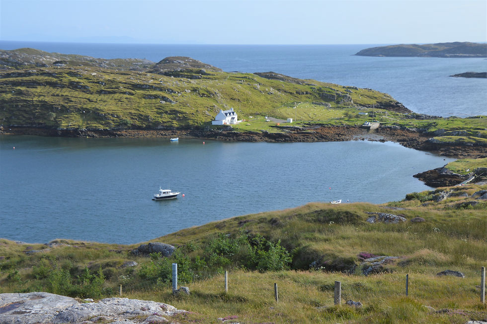
We finished at the pier overlooking Carloway Bay.

In all of our travels there are a few places that I would visit again and the Outer Hebrides is one of them. Maybe it's the combination of a remote location; the incredibly scenic landscapes and hiking trails; the extreme weather conditions (rain and wind add to the feeling of being in the Outer Hebrides); the sense of history; and a peaceful and relaxing pace of life that makes a return trip a distinct possibility. Make your plans to visit - you won't be disappointed.


It's amazing to read that some of the islands have been occupied for over 6000 years, and to learn about brochs. Enjoyed reading this post and looking at the wonderful pictures. Ellie & I have only been to Skye, never to the Outer Hebrides, but it's high up on our list.
Lovely post! I've never been to Lewis & Harris but I'm hoping to make it there this year. Sounds like you had a really great trip! I loved seeing photos of Luskentyre down on the beach as I always just see pictures of it from behind / the side etc. I also never considered taking a ferry from Skye - I might do that and then perhaps go back across to Ullapool! Oooohh I can feel a trip forming already!
Excellent read. Lewis and Harris seem so interesting, it surprises me I’d never heard of them. I see a lot similarities with the west of Ireland. The scenery is so stunning and well captured by you. Great detail throughout.
I had only really researched Skye so this was fascinating to me. Those beaches are beautiful and you're right, they could rival the Caribbean (except in temperature). But all of your pictures are stunning and I am envious! I will be in touch for advice when I get re-plan my trip!
Wow, what a seriously detailed post that kindled my wanderlust! I saw Skye, but clearly need to go back to see more! You were tempted to leave that gate open to let in the sheep, though. Am I right? Thank you!