Folds, Faults and Footsteps: Hiking the Indio Badlands Trail
- Feb 5, 2025
- 7 min read
Why the Indio Badlands Trail
Hiking the Badlands is a remarkable experience because it lets you walk directly through the forces that shaped Southern California. Every bend in the trail reveals tilted rock layers, narrow canyons, and sharply folded hills, all created by movement along the San Andreas Fault system.
Hike Distance: 5.5 miles
Elevation Gain: 767 feet
TrailsNH Hiking Difficulty Calculator: 92 – Moderate

Click here to navigate to the TrailsNH website for a description of the hiking difficulty calculator
What is the Geology of the Badlands
The Indio Badlands terrain was formed through the powerful combination of geology and climate.
Geology: Soft, layered sediments deposited over 5-6 million years were uplifted starting 1-2 million years ago by motion along the San Andreas Fault system.
Climate: Rain & Wind - Once exposed, these soft deposits were rapidly eroded by flash floods. Instead of soaking in, the water rapidly cuts channels, gullies, and washes.

Climate : Temperature & Wind - Typical temperature swings in the desert stress the fractured uplifted rock layers even more. Over time, thermal cycling causes sediments to crack, flake and weaken. Wind removes sediments from the exposed slopes leaving sharp ridges and minimal soil for plant to take root.
Together these forces keep the Indio Badlands raw and unstable, a landscape where erosion outpaces recovery and vegetation remains sparse.

Let's Start Hiking
When we arrived at the trailhead, the parking lot was almost full but fortunately most people were following a short local loop and not heading into the Badlands area. The first mile of the trail crosses a sandy wash that lies in a basin. At the opposite side of the basin lie the hills that form the Indio Badlands.

The hills seem to rise abruptly from the wash. This tortured landscape was created by movement along active strands of the San Andreas Fault system, including the Mission Creek, Banning, and Indio fault zones. Because these faults are concentrated in a narrow zone, rather than rising gradually, the hills erupt from the flat desert wash.

Once we’re in the hills, the trail begins an immediate climb.


Compression Lifts and Erosion Carves the Landscape
The path levels and opens up to an expansive view of the Badlands' unique topography.

Based on appearance and research, I believe this area is within or in close proximity to the Indio Fault Zone. Within the fault zone are closely spaced fractures, tilted and offset beds, concentrated erosion features and sudden changes in slope and elevation. It's the most intensely broken part of the badlands landscape and marks where the uplift is most chaotic and abrupt. This pretty well describes the scene in the following photos

The tilted and folded sedimentary layers in the upper right quadrant aren’t random erosion forms. They were originally deposited as horizontal sediments beds that were later tilted and warped by intense fault movement. The ribbed, fin-like appearance off the ridge line comes from alternating harder and softer layers. Slightly cemented beds resist erosion and stand strong, while weaker layers wash away quickly, exaggerating the fold geometry. The abrupt change from smoother badlands in the foreground to jagged, angular uplifts uphill is a classic surface expression of an underlying fault zone. More evidence that we are walking in the Indio Fault Zone.

These rocks are geologically young, probably a few million years old but they’re already steeply tilted. That steepness tells you uplift is recent and ongoing.

We follow the trail as it descended to the base of the hills where it then began to weave through a small slot canyon.

A slot in the weak sedimentary beds of the badlands forms when flash-flood runoff is forced into these narrow openings instead of spreading out. Because the sediment is soft and poorly cemented, the fast-moving water cuts downward faster than it can widen the channel, creating a deep, narrow slot.

Another unusual erosional feature in the badlands are the cavities or potholes that form in the rock layers.

These circular holes are caused by a combination of rain and wind erosion. During intense storms, rain seeps into surface cracks of the sedimentary rock. Over time the rain water dissolves the weakly bound rock and enlarges the surface openings. Pebbles and coarse sand trapped in these small cavities act like drill bits. As water and wind spins them around, they grind the surrounding sediment in a circular motion, enlarging the cavity even more. This cycle continues until the surface looks like the swiss-cheese surface we see today.

Once a hole opens on both sides, erosion accelerates as wind removes loosened grains, smoothing and rounding the interior. Because the rock is soft and poorly cemented, these openings can form relatively quickly, on the order of thousands, not millions, of years.

The climb known as 'Stairway to Heaven' leads to another section of the hills.

Approaching the ‘top stair’.

Looking back at the group from Friends of the Desert Mountains as they climb the stairway.

At the top, there are excellent views of the near-vertical folds in the hills.

Folds form when rock layers are compressed slowly under the right pressure and temperature conditions, allowing them to bend rather than break.
In Theory

In Reality

After descending via the rocky trail we enter a moderately wide canyon.

It seemed strange for a canyon to suddenly appear in the middle of the uplifted and tortured landscape, but geologically it makes sense.

This satellite view clearly shows a canyon meandering through a large section of Indio Badlands. Over hundreds of thousands of years, rain water runoff has forged a path through the weakest rock layers creating this canyon. It serves as the main outlet for water escaping this rapidly rising landscape and once established, it is almost impossible to dislodge.

Like most canyon floors, this one acts as a seed bank and when the conditions are ideal, it bursts with color. Gentle canyon slopes allow plants to utilize runoff better than steep slopes where water runs off too fast to be absorbed efficiently. In wet years, the floor teems with blooming annuals and perennials.

Notch-leaf scorpion-weed

Sand blazing star

Desert sand verbena

The Mecca Aster was healthy but not yet in bloom. This plant is endemic to the Mecca Hills and a few other isolated area including the Indio Badlands area.


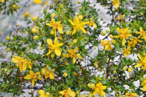
The perennial shrubs benefit from increased rainwater runoff. Although leaf color in a creosote bush can give useful clues about the plant’s condition, it has to be interpreted in the context of desert adaptation. The deep green leaves on this creosote indicate a healthy plant. A lighter green hue suggests the plant is experiencing drought stress, but this does not automatically mean it is diseased or unhealthy. Creosote naturally reduces chlorophyll or sheds leaves during dry periods to conserve water. Because it is extremely stress-tolerant, color changes often reflect survival strategy, not poor health.

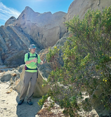

Seeing juvenile creosote bushes is important because it shows the desert ecosystem is functioning, as young plants indicate that older plants are providing shelter and nutrients for new life and that the species is able to reproduce.

Not surprisingly there were a large number of lizard scurrying among the plants. This western whiptail lizard can shed/sever its tail to escape a predator. The detached tail continues to wiggle, distracting the predator while the lizard escapes. However, this is a last ditch effort. Losing a tail exacts a high energy cost for regrowth, which in turn reduces fat storage and hinders sprint performance until tail regeneration is complete.

The incredible geology doesn’t stop once we are in the canyon. These skulls, in a face-off position, are a standout example of differential erosion. Some layers are slightly harder or better cemented than others. As erosion attacks the outcrop, the weaker zones are removed faster, creating the hollowed eye sockets. The larger scooped and smooth surfaces are caused by sheet runoff flowing across the rock face during storms. This combination of forces create the smooth sounded cavities rather than sharp breaks.

To illustrate the scale of this erosional feature, here is Dave climbing the uplifted layer at the base of the skull.

There were several wildflower patch in the sandy soil including these lupines.

We began a slow climb from the canyon floor to the top of ridge.

In the distance we could see people on the ridgeline

After climbing the last switchback, the trail traces the ridgeline.

Along the way there are amazing views of the snow-capped San Jacinto and Santa Rosa Mountains.

A series of sharp switchbacks lead from the ridgeline to a narrow canyon at the base of the hills.


Sunning itself on a rock in the wash was a desert iguana. They are one of the most-heat tolerant lizards in North America. Their preferred body temperature is remarkable high in the range of 100-108°F and they remain active at temperatures that force other reptiles into shade.

Unlike many desert lizards, desert iguanas are primarily herbivorous, feeding heavily on creosote bush leaves and flowers of other heat-adapted plants. Creosote contains toxic compounds that deter most herbivores but desert iguanas have gut microbes and physiology that helps them detoxify these chemicals.

Despite the narrow trail and steep sidewalls, clusters of brittlebush had rooted themselves along the trail.

Vanessa is a group of butterflies known as 'brush foot' butterflies. They get its name because the front legs are small and look like brushes. They are found on almost everywhere continent. I'm fairly confident this is a Painted Lady butterfly, but I'm not 100% certain.

Hiking through the last segment of the badlands before reentering the wash that leads back to the trailhead.

There were many odd erosion patterns here as well.


This rock appears to be melting in the sun.

Back in the wash, the desert floor was covered in sand verbena and desert sunflowers.


It was a slow walk back through the sandy wash but an excellent day spent hiking the Indio Badlands Trail.

Here is a satellite view of the Indio Badlands loop.

0502025


Ik waardeer de duidelijkheid die sequentiële uiteenzetting van ideeën produceert. Observaties blijven gegrond in verifieerbare gegevens. De website biedt aanvullende contextuele informatie over dit probleem. Adoptietrends worden geïllustreerd via interactieve mediasystemen.