Beaches and Sea Stacks Along the Oregon Coast
Our first visit to Oregon began with an easy decision. We wanted to explore the state's legendary coastline. Choosing where to stay, however, proved far more difficult.
With dozens of beach towns stretching along the Pacific, each offering its own character and scenery, narrowing the options wasn't easy. Dave eventually solved the problem by finding a secluded Airbnb in the small community of Netarts. Perfectly situated between Cannon Beach and Cape Meares, it became an ideal base for four days of exploring one of America's most spectacular coastlines.
What we didn't fully appreciate before arriving was that Oregon's beaches are unlike almost anywhere else in the United States. Instead of endless stretches of sand, towering sea stacks rise from the surf, rugged headlands divide one beach from the next amd waves constantly reshape a coastline built over millions of years. Every stop revealed another dramatic landscape and another story written in stone.
Netarts: A Perfect Base for Exploring the Oregon Coast
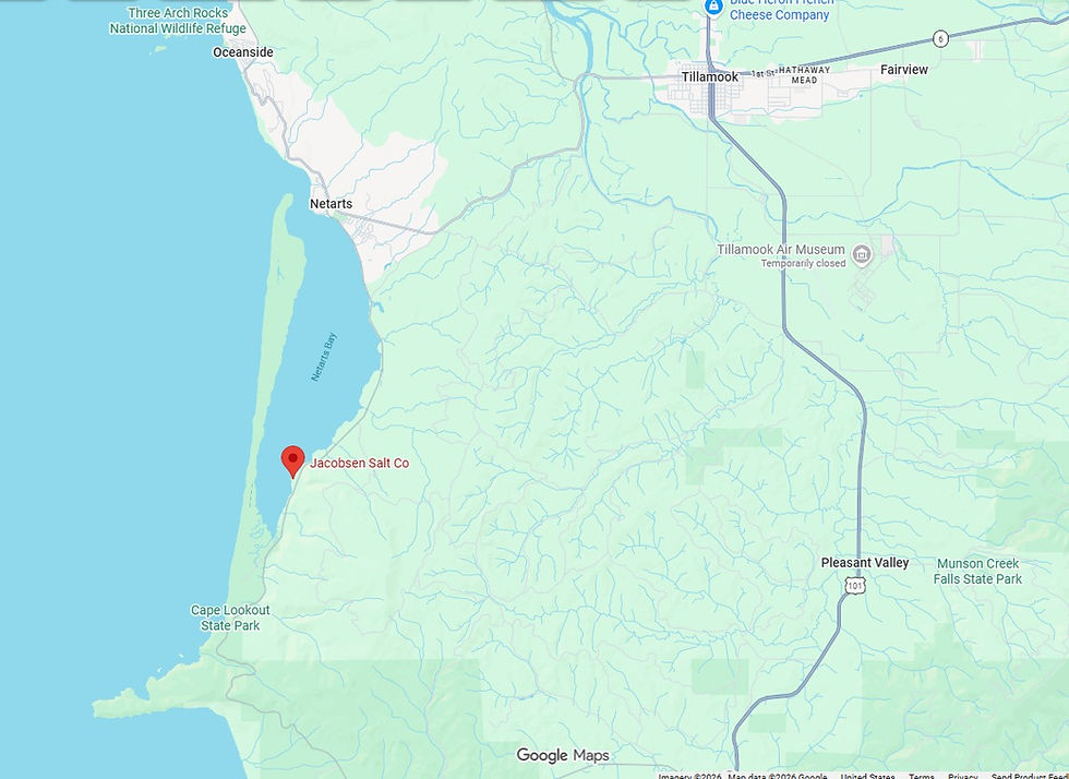
We chose Netarts as our base for exploring Oregon's northern coast. Nestled along the eastern shore of Netarts Bay, this community was centrally located for visiting many of the coast's most iconic beaches, sea stacks, and viewpoints.

Read the Landscape: Netarts Bay
Each morning we woke to a different view of Netarts Bay. The reason was the tide. This shallow estuary, protected from the Pacific Ocean by the narrow Netarts Spit, changes dramatically as seawater flows in and out through its single inlet.
Only about 40 percent of the bay remains underwater at all times. During low tide, the remaining 60 percent is exposed as broad intertidal mudflats, revealing just how shallow much of the bay really is.
In this photograph, the forested ridge on the horizon is Netarts Spit, while the broad expanse in front of it is the exposed intertidal zone. These constantly changing mudflats provide feeding grounds for shorebirds, shellfish, and countless other marine organisms. Understanding the tides transforms this peaceful view into terrain that is reshaped twice each day.

While driving back to Netarts one stormy afternoon, we stopped at an overlook that revealed the narrow sand spit separating the Pacific Ocean from Netarts Bay. Built grain by grain over thousands of years, this natural barrier formed as waves approaching the coast at an angle carried sand northward by longshore drift. Today it protects the bay from the open Pacific while allowing tides to enter through a single inlet.

A short 15-minute walk from our rental brought us to the Jacobsen Salt Company. Established in 2011, Jacobsen Salt Co. became the first company to harvest sea salt in the Pacific Northwest since the 1800s. What began as a small local business has grown into one of America's best-known artisan sea salt producers. Although the shop was closed during our visit, we later picked up a package of Jacobsen Pure Flake Sea Salt at the Tillamook Creamery.

Four Days Exploring Oregon's Northern Coast
With Netarts as our home base, we spent the next four days exploring some of the northern Oregon coast's most iconic beaches, headlands, and hiking trails. From the towering sea stacks of Cannon Beach to secluded coves, dramatic coastal overlooks, and amazing hikes, each destination offered a different perspective on one of America's most spectacular coastlines.
Beneath these diverse landscapes lies a shared geologic story. Ancient tectonic activity, volcanic eruptions, and relentless wave erosion have created, and continue to reshape, Oregon's rugged shoreline. The map below highlights the places we visited during our journey.

The following itinerary offers a preview of each destination before we take a closer look at what makes each one unique.
Stop | Destination | Highlights |
A | Cannon Beach | Haystack Rock, tide pools, Oregon's most famous sea stack |
B | Arcadia beach | Quiet beach, dramatic sea stacks, coastal cliffs |
C | Oceanside Beach & Tunnel Beach | Three Arch Rocks, sea caves, tunnel, exceptional coastal geology |
D | Cape Lookout State Park | Forested headland hike with panoramic ocean views. Read our complete Cape Lookout hiking guide. |
E | McPhillips Beach | Wide sandy beach, sea stacks, sandstone cliffs, Cape Kiwanda viewpoints |
F | God's Thumb | One of Oregon's premier coastal hikes. Read our complete God's Thumb hiking guide. |
Cannon Beach: Home to Oregon's Most Iconic Sea Stack
Our first stop was Cannon Beach, one of Oregon's most celebrated coastal destinations and home to Haystack Rock, the state's most iconic sea stack. Rising 235 feet above the Pacific Ocean, this massive monolith dominates the shoreline and has become one of Oregon's most photographed natural landmarks. In 2013, National Geographic recognized Cannon Beach as one of the 'World's 100 Most Beautiful Places,' a distinction that continues to draw visitors from around the globe.

Haystack Rock's story began nearly 15 million years ago, when lava flows associated with the Columbia River Basalt Group reached the Pacific coastline. As the lava encountered water and soft marine sediments, it cooled into exceptionally resistant volcanic rock. Over time, relentless wave erosion wore away the surrounding coastline, leaving Haystack Rock standing as one of the last remnants of that ancient volcanic period.
Why It Matters
Haystack Rock is far more than a scenic landmark. It demonstrates how differential erosion shapes coastlines. Waves gradually wore away the surrounding, less resistant rocks, while the harder volcanic rock resisted erosion and remained standing. Every sea stack along the Oregon Coast represents a race between rock strength and the relentless power of the Pacific Ocean.
Like many summer days along the Oregon Coast, Haystack Rock emerged and disappeared behind a blanket of coastal fog. While we missed the crystal-clear postcard views, the mist gave the beach a distinctly Pacific Northwest character and made the towering sea stack feel even more imposing. Fortunately, we don't have to rush back to get a better photograph; geologists estimate that Haystack Rock will continue resisting the ocean's relentless erosion for roughly another 3,000 years.

Sometimes the best travel memories aren't perfect blue skies. For us, Cannon Beach will be remembered for its towering sea stack, fog, and one successful selfie.

Arcadia Beach: Reading Oregon's Rugged Coastline
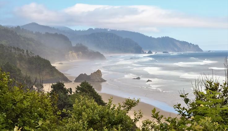
As we continued south, the fog gradually lifted to reveal one of the Oregon Coast's defining landscapes: a series of rugged headlands separated by broad sandy beaches. We stopped at an overlook above Arcadia Beach, where the coastline unfolded before us.
From this vantage point, it's easy to see a repeating pattern that stretches for miles. Resistant basalt headlands project into the Pacific, while the coves between them have been carved into softer sedimentary rocks and filled with sand delivered by waves and coastal currents. These headlands give the Oregon Coast its distinctive, saw-toothed appearance.
In this photograph, you can identify four separate headlands, each separated by a sandy cove, a striking example of how differences in rock strength shape the coastline.
Read the Landscape
The next time you're standing on an Oregon beach, pause for a moment and look beyond the sand. Count the rocky headlands stretching into the Pacific and the sheltered coves between them. Together, they reveal one of the coast's most recognizable geologic patterns; once you start noticing it, you'll see it almost everywhere.
Humbug Point: A Window into Oregon's Tectonic Past
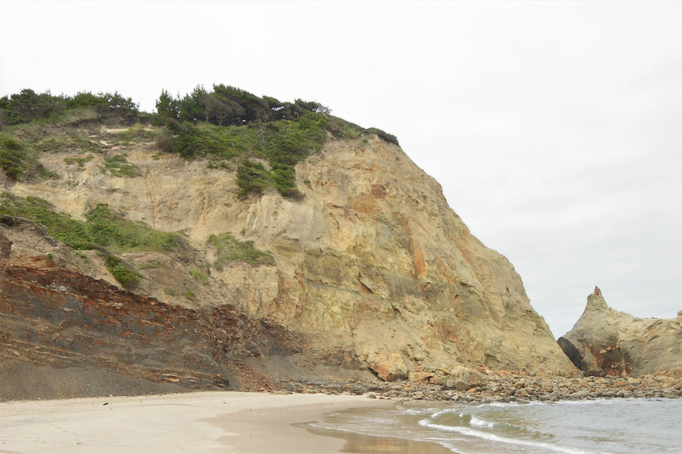
Tucked between two rugged headlands, Arcadia Beach quickly became one of our favorite stops along the coast. As we stepped onto the beach, our attention was immediately drawn to the cliffs of Humbug Point. The orange-brown sandstone layers were anything but flat; instead, they had been tilted and folded almost 90° and fractured by immense tectonic forces.

What caused these dramatic distortions? The answer lies about 70–75 miles offshore, where the Cascadia Subduction Zone marks the boundary between the Juan de Fuca Plate and the North American Plate. Along this 600-mile-long fault system, the dense oceanic plate slowly descends beneath North America. As the two plates lock together, enormous compressional forces build over centuries, gradually lifting and deforming the rocks along Oregon's coast.

That uplift transformed what was once an ancient seafloor into the coastline we see today. At Humbug Point, it tilted and fractured the sandstone layers exposed in the cliffs. Across the region, it raised the Oregon Coast Range, creating the rugged terrain that Pacific waves continue to sculpt into headlands, sea stacks, arches, and sandy coves. Even today, tsunami evacuation signs like the one shown here remind visitors that the Cascadia Subduction Zone remains active beneath the coastline, while the ocean relentlessly reshapes the land above.

Exploring Humbug Point at Low Tide
At low tide, we were able to walk out to Lion Rock, a sea stack that was once part of nearby Humbug Point. Relentless wave erosion carved away the surrounding rock, isolating Lion Rock from the headland.

While exploring, it's important to stay aware of the tides. Every year, visitors become stranded when incoming water cuts off access around headlands and sea stacks. Avoid becoming part of this narrative by checking tide schedules before venturing onto the beaches. We were able to round Humbug Point because the tide was low. At high tide, the narrow passage shown above is often underwater, making it difficult, or impossible, to continue without wading through waist-deep water.
Look Closer
Notice the white band around the base of the rocks. This is the intertidal zone, where barnacles, mussels, and other marine life thrive between high and low tide. It marks the part of the shoreline that is submerged and exposed twice each day.

Arcadia Beach reminded us that the Oregon Coast is more than a collection of beautiful beaches. Every sea stack, headland, and sandy cove is a record of millions of years of Earth's history, written into the landscape.

As we were leaving the beach, a pair of bald eagles soared overhead. Once pushed to the brink of extinction by habitat loss and pesticides, these magnificent birds have made a remarkable recovery and are now a familiar sight along the Pacific Northwest coast. With wingspans of more than seven feet and extraordinary eyesight, they patrol the shoreline in search of fish and seabirds.

Oceanside Beach: Tunnels, Sea Stacks, & Three Arch Rocks
Continuing south, we arrived in the small coastal community of Oceanside, where homes cling to the steep hillside overlooking the Pacific Ocean. From nearly every street, residents enjoy sweeping ocean views framed by sea stacks, rocky headlands, and crashing surf. It's hard to imagine a more spectacular setting for a seaside town.

Dominating the north end of the beach is Maxwell Point, a massive basalt headland that has stood against the Pacific for millions of years. Its rugged cliffs frame the shoreline and provide a striking reminder of the volcanic origins hidden within Oregon's coast.
What to Notice
Viewed from the beach, Maxwell Point naturally divides the coastline, illustrating how a single headland can influence the shape and character of an entire shoreline.

Three Arch Rocks: Oregon's Offshore Giants
As we made our way north across the beach, Three Arch Rocks gradually dominated the view offshore. Rising more than 300 feet above the Pacific, these towering sea stacks are among the largest on the Oregon Coast.
Why It Matters
The same resistant basalt that preserved these sea stacks also created one of Oregon's most important wildlife sanctuaries. Without these towering offshore islands, Three Arch Rocks National Wildlife Refuge would not exist.
Established in 1907 as the first National Wildlife Refuge west of the Mississippi River, the refuge protects more than 250,000 nesting seabirds on just 15 acres of rugged rock. It is home to Oregon's largest breeding colony of tufted puffins, the largest common murre colony south of Alaska, and an important pupping site for the threatened Steller sea lion.

Tunnel Beach: A Passage Through the Headland
What truly sets Oceanside apart is a narrow tunnel cut through the base of Maxwell Point. In 1926, the Rosenberg family, founders of Oceanside, carved the passage to provide access to the secluded beach hidden beyond the headland.
Over the years, landslides repeatedly buried the tunnel. After a major slide in 1979, concrete extensions were added to stabilize and reopen the passage. Ironically, a powerful storm in 1999 washed away much of the accumulated debris, restoring the tunnel to something much closer to its original appearance.

Beyond the concrete entrance, the tunnel becomes a natural passage through the volcanic headland. Rough rock walls close in, the footing turns uneven, and a bright opening at the far end draws you toward the Pacific. At only 125 feet long, the walk takes less than a minute, but it feels like passing through a gateway to another beach.

Stepping out of the tunnel, we were greeted by the dramatic scenery of Tunnel Beach, also known as Isolation Beach. Enclosed by towering cliffs, bordered by sea stacks, and scattered with tide pools, it immediately felt like a place shaped as much by geology as by the relentless Pacific Ocean.
Look Closer
Notice the rounded cobbles scattered along the upper beach. Unlike the sand, these larger stones are too heavy for everyday waves to move. Winter storms and exceptionally high tides push them ashore, creating a natural record of the Pacific Ocean's power.

Once on the beach, we could appreciate just how enclosed it really is. Towering cliffs rise on both sides, with Maxwell Point anchoring one end and...

... Hatbox Rock at the other end, creating a shoreline that feels far more remote than its location suggests.

Geology Gem
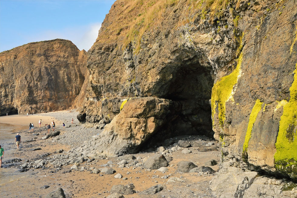
While exploring the beach, we noticed a sea cave carved into the base of the basalt cliffs. Sea caves form where waves repeatedly exploit fractures and weaker zones in the rock. Although this cave may continue to enlarge over time, it represents just one stage in the ongoing evolution of Oregon's coastline.
One final view from Tunnel Beach revealed yet another collection of rugged sea stacks. Each sculpted by the same relentless waves, yet no two are exactly alike.

Tillamook Creamery: A Delicious Detour
After spending the day exploring sea stacks, headlands, and hidden beaches, we were ready for a different kind of Oregon experience. No visit to the northern Oregon coast is complete without stopping at Tillamook Creamery.

Dave first discovered Tillamook ice cream in 2019, and it quickly became one of his favorites. Naturally, we couldn't pass up the chance to enjoy a scoop just a few miles from where it's made.

Watching thousands of blocks of cheese roll down the production line made one decision easy; we left with two containers of Tillamook's famous macaroni and cheese for dinner.

McPhillips Beach: A Different View of Cape Kiwanda
Our original plan for today was to continue along the Three Capes Scenic Drive, but a long-term road closure near Cape Meares sent us in a different direction. Instead, we headed south toward Cape Kiwanda.
Like much of our Oregon adventure, another blanket of low clouds greeted us as we approached, reminding us that summer sunshine isn't always part of the Oregon Coast experience.

Before reaching Cape Kiwanda, we spotted a small, unmarked road leading toward the ocean. Curiosity got the better of us, and it led to one of our favorite surprises of the trip: McPhillips Beach.

As we stepped onto McPhillips Beach, we were once again greeted by dark basalt outcrops. But this time, something was different. Intermixed with the volcanic rock were light-colored sedimentary cliffs and boulders, hinting at a more complex geologic story than we had encountered elsewhere along the coast.

The dark rocks in front of us are part of the Columbia River Basalt Group, formed by enormous lava flows that reached the Oregon Coast about 15–17 million years ago. These ancient lava flows continue to define portions of the coastline, appearing today as rugged cliffs, headlands, and rocky outcrops.

Look Closer
This scene preserves two distinct chapters of Oregon's geologic history. The fractured basalt in the foreground records ancient lava flows, while the pale sedimentary cliffs behind it were deposited beneath an ancient ocean. Seeing them side by side reveals how volcanic eruptions and marine environments, separated by millions of years, combined to create the rock formations we see today.

A Walk Toward Cape Kiwanda
As we continued south, the coastline began to change. The familiar pattern of rugged basalt headlands gave way to a landscape unlike the one we'd been exploring farther north.

Climbing Oregon's Giant Sand Dune
Before exploring Cape Kiwanda itself, we turned our attention to the massive dune rising beside the headland. Stretching toward the cape, it is one of the largest active dunes on the Oregon Coast. Rising nearly 100 feet above the beach, the climb is far more challenging than it first appears, with every step up the loose sand sliding you partway back down.
The dune exists because Cape Kiwanda creates the perfect combination of abundant beach sand, strong onshore winds, and a natural barrier. Wind continually carries sand inland, where it piles up against the sandstone headland, gradually building this massive dune. Although it appears permanent, every winter storm and windy day reshapes its surface.

Exploring Cape Kiwanda at Low Tide
Since our visit coincided with low tide, we were able to scramble across the rocky headland for a closer look. Narrow wave-cut channels, towering cliffs, and scattered boulders surrounded us as seawater pooled among the maze of rocks.

Why Is Cape Kiwanda So Different
Unlike many of Oregon's rugged headlands, which are formed from hard volcanic basalt, Cape Kiwanda is composed primarily of the Nestucca Formation, a thick sequence of marine sandstone deposited about 20 million years ago. Because sandstone is much softer than basalt, the Pacific Ocean has carved the headland into cliffs, narrow passages, sea caves, and arches. Every winter storm continues to reshape the Cape.

Look Closer
Notice the narrow opening at the base of the cliff. This small sea arch formed where waves exploited natural fractures and weaker layers within the sandstone. With each winter storm, the opening grows a little larger. Eventually, the arch will collapse, leaving behind an isolated sea stack before the ocean continues its work.
Now look at the horizontal layers running across the cliff face. Their nearly level orientation contrasts sharply with the steeply tilted sandstone exposed at nearby Humbug Point, revealing how differently tectonic forces have shaped this stretch of coastline. The rounded boulders below are fragments of the cliff that have broken away and been smoothed by years of wave action.
Standing within what feels like a small ocean-carved canyon at the tip of Cape Kiwanda, it's hard not to appreciate that these rock formations remain a work in progress. Every fallen boulder, widening arch, and freshly exposed cliff records another step in the coastline's continual evolution.

The Other Haystack Rock: A Basalt Guardian
Just 0.4 mile offshore stands Haystack Rock, one of the Oregon Coast's largest sea stacks. At first glance, it appears to be part of Cape Kiwanda, but the two have very different geologic histories. Together, they tell one of the coast's most intriguing geologic stories.
Unlike Cape Kiwanda's sandstone cliffs, Haystack Rock is basalt. Scientists believe it formed when magma intruded into soft marine sediments beneath the ancient seafloor, cooling into the massive volcanic rock that stands offshore today.
That difference has shaped the coastline ever since. Haystack Rock acts as a natural breakwater, reducing the force of incoming waves before they reach Cape Kiwanda. Many geologists believe this has helped preserve the cape's sandstone cliffs, making Haystack Rock more than a dramatic landmark; it's an active part of the landscape's evolution.

Haystack Rock Is Slowly Losing the Battle
We drove a short distance into Pacific City for a closer look at Haystack Rock. From the beach, its immense size becomes even more apparent, yet its jagged outline and fractured surface reveal that the Pacific has been slowly wearing it away.

Although the 327-foot sea stack is undoubtedly smaller than it once was, it continues to serve. Someday Haystack Rock will disappear beneath the waves, but for now it remains one of the reasons the sandstone headland has endured for so long.

Final Thoughts
Every beach we visited revealed a different chapter of the Oregon Coast's geologic story. Some showcased ancient volcanic activity, while others preserved evidence of long-vanished seas, demonstrating that no two stretches of coastline share the same history. Looking north from the overlook, it was also clear that those stories are still being written. Every crashing wave, winter storm, and shifting dune continues to reshape the shoreline.

Explore More of the Oregon Coast
If this journey inspired you to explore more of Oregon's remarkable coastline, these guides are a great place to continue.


The northern coast of Oregon sounds like a broad subject, since a coastline can be described through landscape, communities, weather, or travel. I have only read the title, so I do not know which angle the article takes. Even the phrase gives a sense of place without claiming what it is like to be there. I was reading at home during a pause and thought about the different ways people spend a quiet evening, including games; ww88 is a name I have heard in that unrelated setting. I’m left curious about which part of the coast the writer chose to focus on.
Đọc bài về bờ biển phía bắc Oregon, mình thích nhất cảm giác được tạm rời khỏi những chuyện thường ngày để nghĩ về một vùng biển xa. Lúc nghỉ giữa giờ, đôi khi mình nghe người quen nhắc đến Game bài đổi thưởng; cái tên https://ao88s.net làm mình liên tưởng đến kiểu chủ đề giải trí rất khác với cảnh biển trong bài. Mình chưa biết nhiều về lĩnh vực đó, nên cũng không có nhận xét gì thêm. Hai mạch nghĩ trái ngược vậy lại khiến bài viết đọng lại trong đầu lâu hơn một chút.
Bài về bờ biển phía bắc Oregon gợi ra một địa điểm có thể được nhìn qua cảnh quan, hành trình hoặc đời sống địa phương. https://23win.to/ Tựa đề chưa cho biết bài tập trung vào khía cạnh nào, nên tôi không muốn tự thêm các chi tiết về nơi này. Sau khi đọc, tôi thấy những bài viết về một vùng địa lý thường phụ thuộc nhiều vào góc nhìn của người kể. Cùng một nơi có thể hiện lên khác nhau qua thiên nhiên, thời tiết và nhịp sống. Tôi vẫn tò mò phần nào đã khiến tác giả chọn kể về vùng bờ biển ấy.
Bài viết giới thiệu về bờ biển phía bắc Oregon, mô tả cảnh quan và những điểm dừng chân đáng chú ý. Tôi chưa từng đến Oregon nhưng qua bài viết hình dung được những bãi biển hoang sơ và rừng cây ven biển. Tôi thích đọc về những vùng ven biển vì chúng thường mang lại cảm giác yên bình. Bài viết khiến tôi muốn tìm hiểu thêm về khu vực này nếu có dịp đi du lịch. Khi đọc bài, tôi đang ngồi trong nhà, thỉnh thoảng mở ww88 chơi vài ván để giải trí. Những bài viết kiểu này nhắc tôi rằng có nhiều nơi đẹp vẫn đang chờ được khám phá.
O texto sobre a costa norte do Oregon me chamou atenção pela forma como a paisagem parece reunir mar, vento e pequenas mudanças de clima em pouco espaço. Não é uma descrição apressada de praia; há uma sensação de estrada e de descoberta gradual, mesmo sem muitos detalhes sobre cada parada. Ao ler sobre esperar uma abertura no tempo para observar melhor a costa, lembrei de ter ouvido alguém mencionar 58win numa conversa sobre jogos de aposta durante momentos de espera. Nunca usei o serviço, então isso ficou apenas como uma associação passageira. A paisagem descrita, por outro lado, permaneceu mais presente na minha cabeça.