Pushawalla Palms Oasis Trail: Hiking Along the San Andreas Fault
- Mar 15, 2025
- 8 min read
Updated: May 18
Trail Overview
Location: Indio Hills
Trail Type: Loop or Lollipop
Distance: 4.7 miles
Elevation Gain: 574 feet
Difficulty: Moderate
Terrain/Obstacles: Sections of exposed ridgeline trail, some scrambling up a boulder-choked gully, and sections of eroded trail
Hike Breakdown: Hike is suitable for novice hikers who want a challenge
Best Time: October-May
Highlights: Hiking on the San Andreas Fault system, Indio Hills, desert fan palm oasis
TrailsNH Hiking Difficulty Calculator: 73 - Moderate

Click here to navigate to the TrailsNH website for a description of the hiking difficulty calculator
Why Hike Pushawalla Palms Oasis Trail
Pushawalla Palms offers one of the best opportunities in the Coachella Valley to see how movement along the San Andreas Fault creates life in the desert. This scenic loop crosses uplifted ridges before descending into a hidden canyon where groundwater sustains groves of native California fan palms. Hiking here means traveling across an active tectonic corridor where the San Andreas Fault continues to shape both the land and the life around it.
Tectonic Forces Behind the Indio Hills & Pushawalla Palms
The Pushawalla Palms Trail is situated in the western Indio Hills of the Coachella Valley Preserve. These hills are composed of sediments that began pouring into the low-lying valley from rising mountains 6-10 million years ago. Then, 4-6 million years ago movement along the San Andreas Fault system, including the Mission Creek Fault that exists here, compressed, folded, and uplifted these ancient sediments into rugged hills surrounding Pushawalla Canyon.

The same tectonic forces that fractured and compressed the underlying rocks created barriers that redirect groundwater toward the surface. Where this hidden water emerges in the hills and canyons, native California fan palm groves thrive.
Using the California Department of Conservation’s interactive map, we located the Pushawalla Palms trailhead (circled in black) directly on the North Branch of the San Andreas Fault (Mission Creek fault). The map also reveals a dense cluster of active faults surrounding the Indio Hills area.
On January 19, 2026, a magnitude 4.6 earthquake and hundreds of aftershocks struck (circled in red) within 8 miles of the Pushawalla Palms trailhead, highlighting the ongoing activity of the San Andreas fault in the Coachella Valley.

The San Andreas Fault
The San Andreas Fault is one of the world's most famous tectonic boundaries, marking the divide between the Pacific and North American plates. The fault extends roughly 750 miles across coastal California to northern California in the Point Reyes area. Rather than a single crack, the San Andreas is a broad zone made up of multiple strands that bend, branch, and interact with one another.
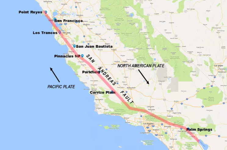
Despite the plates moving past each other at an average rate of 1-2 inches per year, data suggest the Mission Creek Fault has accumulated 20-30 feet of elastic strain since the most recent surface-rupturing earthquake in 1857. That would place the surface displacement on par with the 24-foot fault slip recorded during the 1906 San Francisco earthquake.
Let's Start Hiking
The Pushawalla Palms Loop Trail begins at the trailhead situated on Thousand Palms Canyon Road. After crossing a wash, the trail leaves the parking area and follows a path cut directly into the hillside.

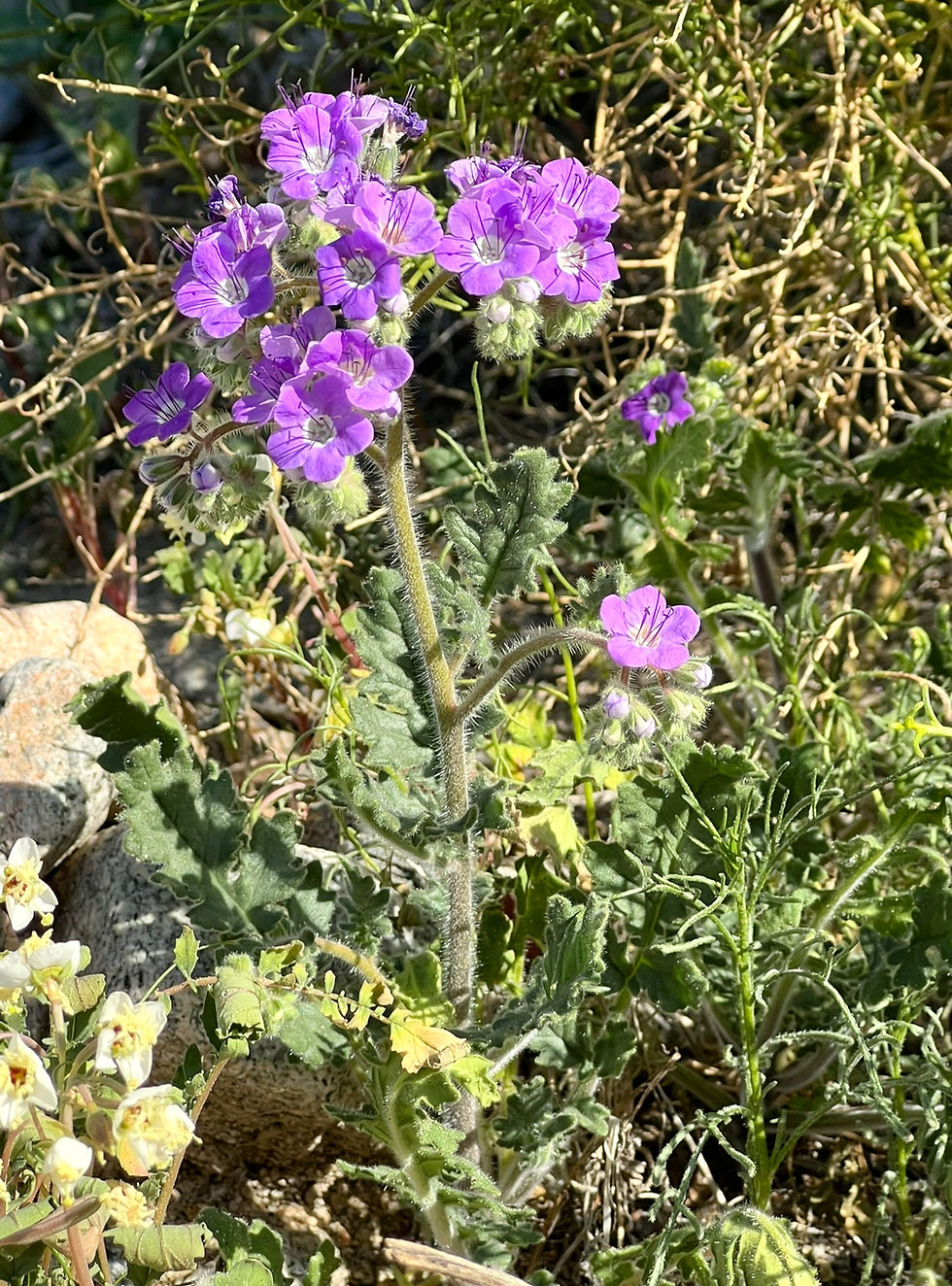
Wildflowers along the trail make this wash a favorite for locals and visitors alike. When early winter rains, cool temperatures, and a good seed bank align, the washes and hills erupt with wildflowers. Among those commonly found in the wash are:
desert dandelion

distant phacelia
and browneye primrose.

The same rain that helps wildflowers bloom can become catastrophic if the storms are too intense. Flash floods move fast and hit hard. They act like a bulldozer, stripping away soil and uprooting plants and shrubs. As this photo illustrates, flash floods have drastically transformed the terrain.

To our left, we noticed a few hikers walking in a wash, likely making their way back from Pushawalla Palms.

Reaching the base of the Indio Hills, we noticed a lone bladderpod plant tenaciously holding onto a spot on a gradually eroding hillside.

The plant gets its name from its distinctive, inflated pods that protect seeds and aid in dispersal by wind or water.

Gaining the Ridgeline
A short climb of the first hill provides an impressive view of the Coachella Valley Preserve at Thousand Palms Oasis.

This ridge line trail offers the best option for hiking to the Pushawalla Palms Oasis because the crowd thins out with each successive hill.

This is one of the best 'born flat, uplifted later' landscapes in Southern California.

Even today, the sediments remain loosely consolidated, making the trail vulnerable to erosion. Each rain event impacts trail conditions to some extent.

Hiking is better when you occasionally admire the view behind you.

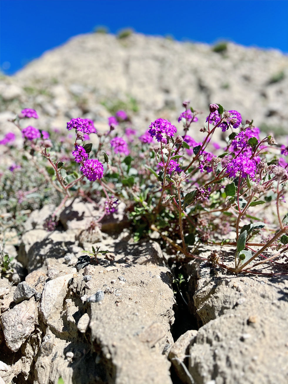
Even the ridge becomes a patchwork of desert sunflowers and sand verbena.

Under these conditions, it wasn't surprising to find this Desert horned lizard hiding in the rocks. They frequent wildflower patches because these areas provide an ideal combination of food and shelter. Wildflower patches in the desert often provide a micro-habitat of loose, sandy soil, shade from the sun, and a high concentration of harvester ants, the lizard's primary food source.

Following the ridge, we spotted the Horseshoe Palm grove below, a linear stand of California fan palms tracing the Mission Creek Fault. This aligned, green band serves as a living map of the active fault zone beneath your boots.

There were no remaining hikers by the time we reached the last hill.

Descending Into Pushawalla Canyon
Once we crested, the path began descending into Pushawalla Canyon.

Along the trail, we spotted these ghost flowers,

lilac sun bonnets, and

a tiny desert five-spot flower. The flowers are dark pink to lilac with five overlapping petals, each with a dark red/purple spot near the base. They open in the afternoon and close at night.

Several sections of the trail leading were heavily eroded.

Brittlebush in the drainage gullies were in bloom. When winter and spring rains flow in the gullies, these plants get a bonus water supply compared to plants on the dry ridges. As a result, they often respond with prolific blooms.

As we get closer to the canyon, the trail steepens abruptly and is filled with boulders.

First Steps Into the Oasis
The contrast between the exposed ridgeline and the canyon floor at the entrance to the Pushawalla Canyon is immediate. As the trail drops into the canyon, vegetation increases and soils darken, reflecting the presence of a shallow groundwater table influenced by faults. The hillside greened up spectacularly because these slopes are literally where the desert's leftovers pile up.
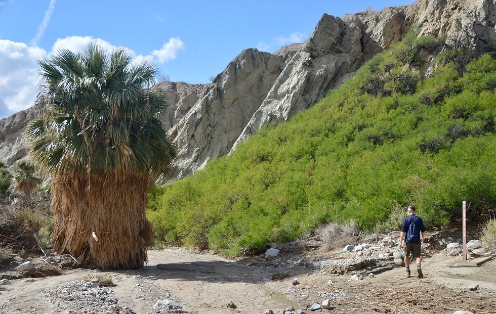
Water, rock, and nutrients are all funneled through here and mix over time. Thick vegetation, fed by shallow groundwater, locks the soil in place, creating a nutrient-rich environment that supports a broad plant community, including these honey mesquite trees.

The fuzzy yellow flowers of the honey mesquite are called catkins. Each yellow cylinder contains hundreds of tiny individual flowers tightly packed along a central stem. Instead of investing energy in showy petals, mesquite relies on sheer numbers. One visit by a single bee can result in the pollination of dozens of flowers at once.

The Story About the Desert Fan Palms
But the real story is the grove of California desert fan palms lining the canyon floor as far as the eye can see.

Along with the emergence of mesquite clusters in an otherwise sparse landscape, plant growth on the canyon floor follows the pattern of faults and fractures. Fault-fed groundwater sustains groves of these water-hungry plants. It's estimated that a healthy mature fan palm utilizes 50-130 gallons of water per day during the summer months.

Unlike most desert plants that have adapted to survive, desert fan palms disregard water conservation practices. Sporting huge fan-shaped green leaves, desert fan palms transpire heavily, losing an estimated 25 to 80 gallons of water daily through their leaves during peak summer

The characteristic skirt of dead fronds on a California fan palm serves as more than just a visual feature; it's an indicator of a mature and healthy specimen. These retained fronds help shade the trunk and reduce water loss, protecting the palm in the desert environment.

In Pushawalla Canyon, water frequently alternates between surface flow and subsurface flow through porous, flood-deposited gravels. Surface water reappears when bedrock rises to force groundwater up, with flow duration dictated by seasonal conditions.

Hard to believe this picture was taken in the middle of the hottest, driest desert in North America.

We followed the trail up canyon and continued exploring the grove.


In this section of the oasis, the palms are arranged in more dense clusters and centered around a shallow surface stream visible in the center of the photo, then trailing to the lower left corner.

This type of water flow is called a seep. Seeps keep soil damp at root depth even during dry years. Fan palms require this constant, saturated sediment for germination and early survival, with young shoots visible as grass-like blades in this photo, representing the next generation of Pushawalla palms.
The orange-red color of the surface water comes from iron-rich sediments and rocks in the canyon. As groundwater moves through the fractured bedrock, it dissolves small amounts of iron. The streambed becomes coated in orange and red rust as iron oxidizes upon contact with surface oxygen.

The 60 to 80-foot-tall palms create a microhabitat by moderating the harsh desert environment around them. Their dense crowns and skirts provide shade that lowers ground temperatures and reduces evaporation, allowing moisture to persist longer in the soil. Fallen fronds and organic debris enrich sandy sediments, supporting insects, birds, and small mammals. Together, shade, moisture, and shelter allow a diverse plant and animal community to exist within the palm grove that cannot survive on the surrounding exposed slopes.


A Silent Trailside Discovery
Rattlesnakes are drawn to desert fan palm oases because these areas offer reliable water, shade, and abundant prey. The cooler, humid conditions beneath the palms also help snakes regulate body temperature during hot months. Unfortunately, this Southwestern speckled rattlesnake's predators are also drawn to its oasis habitat. Despite its speckled, sand-colored camouflage that blends in perfectly with the gravel, it was ultimately outmatched by an effective predator.
The feeding pattern in this photo strongly points to a red-tailed hawk or great horned owl. A few clues: raptors kill snakes by grasping them behind the head and then often removing the head to avoid venom; the carcass is left partially consumed, and there is no crushing damage typical of mammals. The other likely predator would be a roadrunner, but the clean removal of the head and the lack of peck marks and tearing along the skin make it less likely to have been ‘death by roadrunner’. Every photo indeed tells a story.

Climbing Out Through a Boulder-Choked Gully
As quickly as the oasis appears in the canyon, it disappears, and the terrain once again belongs to the desert scrub plant community.

The climb out of the canyon involves navigating a boulder field.

We found yet another rusted-out car frame on a Coachella Valley hiking trail.

Onto the Plateau and Into the Wash
After scrambling up the boulder-choked gully, the route levels out across a broad plateau.
At this point, hikers have an option to return to the ridge line or follow a different trail that returns to the railhead through a wash.

To change things up, we frequently choose the wash trail, which is less than 1.5 miles long.

In the middle of the creosote flats, we found ourselves walking through a mesquite hummock. A cluster of honey mesquite isn't a random occurrence. Their deep roots, descending 30-100+ feet, are tapping fault-fed groundwater. They are a living marker of water in a dry landscape.

Closing Thoughts
Spotting the trailhead marked the end of another fantastic day of exploration in the Indio Hills. Pushawalla Palms is more than a scenic desert hike. It is a living demonstration of how tectonic forces shape the landscape and create a rare oasis where native California fan palms survive.

Inspired by Pushawalla Palms Oasis trail and looking for a more dramatic oasis? Read about Willis Palms. Or if you want to continue your adventure in the nearby Indio Hills and explore the dramatic ridges and maze-like canyons of the Indio Badlands, where erosion has sculpted one of the Coachella Valley's most striking landscapes
250226


Comments