Hiking Willis Palms Oasis: Where the San Andreas Fault Breathes Water
- Feb 27, 2025
- 10 min read
Updated: May 16
Trail Overview
Location: Indio Badlands
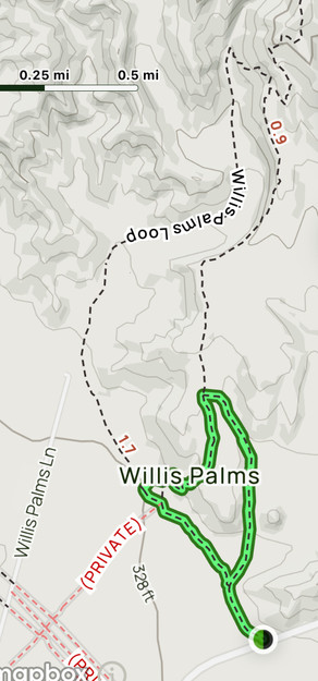
Trail Type: Lollipop
Distance: 4.4 miles
Elevation Gain: 531 feet
Difficulty: Moderate
Terrain/Obstacles: Sandy wash, sections of eroded trail, fallen palms, and other minor obstructions
Hike Breakdown: Hike is suitable for novice hikers who want a challenge
Best Time: October-May
Highlights: Hiking on the San Andreas Fault system, red fault gouge hills, slot canyon
TrailsNH Hiking Difficulty Calculator: 65 – Moderate

Click here to navigate to the TrailsNH website for a description of the hiking difficulty calculator.
Why Hike the Willis Palms Loop Trail
Hiking the Willis Palms Trail is not about conquering a summit or testing your endurance. It’s about taking the time to look around and appreciate the environment. It’s about noticing how geology and water come together to create beauty in this unexpected location.
This impressive trail showcases the finest aspects of desert hiking and palm oases:
Walk through one of the largest native fan palm oases in the Coachella Valley.
See how the San Andreas Fault brings groundwater to the surface.
Experience three distinct desert habitats.
Spot wildflowers, lizards, and birds
Enjoy an educational hike rich in geology and ecology.
So Many Trail Options
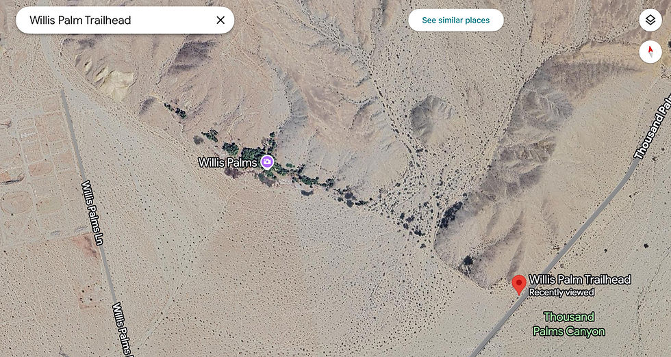
Several trails lead to or through the oasis, and all start at the same trailhead. For most of our hikes here, we follow a modified version, on the right, that incorporates the best of both trails. No matter which one you follow, you won't be disappointed.


How the Indio Hills Were Formed
Nearly all the geological features observed on this hike were shaped by tectonic activity along the San Andreas fault system. The Indio Hills complex, which appears as a narrow ridge rising from the flat Coachella Valley, was uplifted by movement along this fault, as shown in the highlighted aerial view.

These hills are not randomly situated; they are a dramatic wedge-shaped uplift formed by intense tectonic pressure between two main branches of the San Andreas Fault system: the Mission Creek fault to the northeast and the Banning fault to the southwest. As these faults squeeze and lift the land, they create this tortured 'badlands' terrain, which stretches between the desert floor and the fault lines themselves. See the map below.

Most of the time, these faults grind against each other as they move. But here's the twist: in this region of the Indio Hills, neither fault runs perfectly straight. They jog slightly to the west to form a restraining bend that causes the two sides of the fault to push against each other. When that happens, the land caught between them doesn’t just slide — it gets pushed upward. The Indio Hills exist because the ground was squeezed up where two faults collide.

According to the California Department of Conservation's interactive fault activity map, the latitude and longitude for the Willis Palms trailhead (marker circled in blue) place us directly on the Banning Fault, which is identified as the South Branch of the San Andreas Fault.

Biodiversity Showcase on a Small Scale
We’re fortunate to live in the Sonoran Desert, which is widely considered to be the most biodiverse desert in North America. It boasts a remarkable array of plant and animal life, including more than 2,000 plant species and 550 animal species. This high biodiversity is attributed to its unique climate, which includes warm winters and summer monsoons, as well as its varied topography, including mountains and canyons, which provide diverse habitats.

The Willis Palm trails highlight Sonoran biodiversity in miniature. Despite the desert wash setting, slight variations in topography and water availability along the fault line create a mosaic of distinct habitats and plant communities, which become apparent while hiking.

We barely hit the trail before spotting a coyote, which was unusual as these elusive, nocturnal animals rarely show themselves to humans. While some coyotes are nomadic, others defend fixed territories, which can exceed 15 square miles in scarce desert environments. These opportunistic omnivores consume readily available food, including fruits, vegetables, and fan palm fruit. They also use washes as vital corridors for travel, hunting, and refuge.

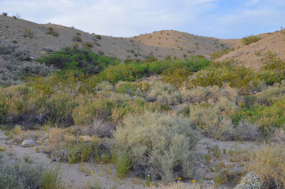
To start, we are surrounded by desert wash habitat. Desert washes or dry streambeds carry water only during and shortly after rainstorms. They are ecological lifelines in the Sonoran Desert. Even though they may be dry most of the year, they provide unique benefits that help sustain desert biodiversity.

Because washes collect and hold more moisture than surrounding slopes, they support relatively ‘lush’ layers of plant life. A great analogy for this plant structure is to think of them in terms of a layered dessert, where each plant layer contributes to the overall structure and health of the wash habitat.

The Three Layers of the Desert Wash Habitat
Within the first 0.3 miles, we can see plants from each layer of the desert wash habitat, and they will continue to be present through the trail.
Canopy: This top layer is formed by the tallest shrubs and small trees that are able to access deeper moisture reserves or temporarily benefit from occasional flooding events. This layer provides some shade and moderates the temperature for the plants and animals that reside beneath it, including these smoke trees.
Leafless with photosynthetic branches, smoke trees minimize water loss. Their roots host nitrogen-fixing bacteria, which nourish the plant and enrich the soil, allowing them to survive in arid, nutrient-poor washes.


Subcanopy: The middle layer in a desert wash consists of large shrubs that can tolerate the slightly drier conditions without relying on the influence of the canopy; examples include indigo bushes and catclaw.
On a hike, the indigo bushes were in full bloom, showcasing their small, deep purple, pea-like flowers that typically appear in late spring/early summer, or after rain. Though their intricate, gray-green branches resemble a smoke tree, close inspection reveals key differences.
Indigo: Medium, 3–6 ft shrub with soft, flexible branches and late winter/spring clusters of deep indigo-purple, "dusted" flowers.
Smoketree: Medium-large, 20 ft tree with rigid, spiny branches; blooms post-spring floods with bright purple/violet flower clusters at branch tips.
During extended dry periods, indigo can halt growth and photosynthesis almost completely, resuming quickly after rains. This allows the indigo bush to survive years between significant rain events.

Though restricted to small regions in CA, AZ, and Baja California, indigo is abundant along Sonoran Desert trails, as shown by the dark green area on the map.

Groundcover: This layer of low-growing shrubs, including cheesebush, stabilizes the soil, provides food for small animals, and contributes to the nutrient cycle. The prolific cheesebush thrives on unstable ground. Its lightweight seeds, spread by wind and water, settle in sandy downstream deposits. These seeds germinate quickly, and the fast-growing seedlings rapidly secure a competitive advantage in resource-scarce environments.

Cheesebush greens up rapidly after rain because dormant stem and root buds activate instantly. Fueled by stored starches acting as a "battery," the plant produces fast new growth. Here is a close-up of this rapid development

Lush vegetation provides food and shelter for reptiles like the heat-tolerant desert iguana. They are one of the most heat-tolerant reptiles and can remain active in temperatures up to 115°F. They forage during the hottest part of the day, gaining a potential advantage over predators.

Desert iguanas are 16-inch, blunt-headed reptiles that rely on creosote bushes for food and shelter. These largely herbivorous, burrowing lizards eat leaves, flowers, and occasionally insects.

Sign You Are Walking on a Fault
Unlike the popular image of a giant crack, the San Andreas and Banning faults show no obvious surface traces today, as erosion has hidden them over hundreds of thousands of years; however, indirect evidence remains along the trail.
Sudden appearance of more dense vegetation. Notably, the vegetation and plant coverage at the base of the hills is significantly greater than in other areas of the wash. This dense vegetation could not possibly be supported by annual rainfall. Fault-fed groundwater is likely supplying extra water to these plants.
Emergence of clusters of mesquite, willows, or cottonwoods in an otherwise sparse desert landscape. Several small to moderate-sized stands of mesquites were growing at the base of the hills. Their persistence in dry landscapes indicates the existence of significant subsurface moisture.


California fan palms are used as fault markers. The sudden appearance of fan palms on the slopes indicates we are on the fault. California fan palm cluster in areas where fault activity creates pathways for groundwater to reach the surface. This pattern of fan palm oases is repeated throughout the Indio Hills:
Thousands Palms - Mission Creek fault
Pushawalla Palms - Mission Creek fault
Hidden Palms - Banning Fault

Linear groves of vegetation on the desert floor. Stand anywhere in front of these palms, and you can trace a thin straight line of green.

Palms align along the Banning fault, where broken rock allows water to seep up, creating a linear desert oasis.
After slightly less than a half of a mile, the palms thin out and the slope transitions back to the desert slope groundcover: creosote, brittlebush, and isolated cacti.

During our hikes, desert wildflowers put on a show. These "ultimate gamblers" bloom, seed, and die in just 6-8 weeks when conditions are right.
Emory rock daisy and notch-leaf scorpion weed.


Bristly langoisia

Ghost flower

The Ancient Sea of the Imperial Formation
Nearby, smooth yellow mounds rise as exposed 5–7 million-year-old beds of the Imperial Formation, which formed when the Gulf of California once covered the Coachella Valley. Comprised of silt, clay, and marine fossils, these mounds are not dunes, but remnants of a shallow, 16 to 90-foot-deep sea.

Fault-driven uplift exposed these beds, but they represent only the eroded edge of a 5,000–6,500 ft thick marine layer. While they are visible at Willis Palms, the Imperial Formation usually lies 0.6–2.0 miles deep.

The Imperial Formation's golden hue comes from iron-bearing minerals in marine sediments. While wetter climates turn iron into deep red oxides, the drier, slower weathering of the Coachella Valley creates a lighter, golden oxidation.

Following the Wash
About a mile from the trailhead, the wash begins turning northward. The landscape changes as we begin hiking into the Indio Hills and leave the open desert floor behind us.

Flowering shrubs and wildflowers continue to dot the landscape including this catclaw acacia.

Milkweed, a drought-tolerant, rapid-spreading plant often considered an agricultural weed, is essential for Monarch caterpillars, which rely on it exclusively for food and egg-laying in the U.S. In the Sonoran Desert, it thrives in sandy washes.

I managed to capture this photo of a Queen caterpillar on a flowering milkweed.

The wash was full of plant life taking advantage of rainwater runoff from the hills…

... including this Arizona lupine.

Finding young brittlebush is promising, but their first few years are critical. Underdeveloped roots leave them vulnerable to drought, heat, and competition.

After a mile in this wash, we begin a short climb out of the wash on a trail section built into the hillside.

After reaching the crest, we had an excellent view of the path we had taken through the wash and the Santa Rosa Mountains in the distance.

Hiking on the Bench
Now, it's a march for the next mile on this bench, which stands about 100 feet above the wash.

We are entering the second major habitat, the Creosote Bush Scrub. The soils here are drier, coarser, and more compact. Generally, it is a harsh microclimate with limited water infiltration and minimal organic material, which hinders the germination of new species. The plant community here consists primarily of creosote and brittle bush, the drought specialists. This area exemplifies the classic 'desert environment'.

While photographing a flowering creosote bush, I spotted a 3-5 inch desert horned lizard hiding in the shade. Recognizable by their flattened, spiny, toad-like appearance, these lizards thrive in open, arid habitats and feed primarily on harvester ants, which can make up to 90 percent of their diet.

Three of our friends joined us on this hike.

After walking a mile, we could see the Willis Palms again. However, this time we were looking down at the cluster of palms.

Following a steep section of the trail leading to the oasis.

Entering the Oasis
A short but steep path leads directly into the oasis. The change is remarkable; you are immediately surrounded by a vibrant green area filled with plants. We have now entered the Riparian/Oasis Habitat, the third habitat we've encountered on the trail.

Of all the sights along the Willis Palms Loop Trail, none is more iconic than the towering California fan palm (Washington filifera), also known as the desert fan palm. How many palms can be seen here? The only known survey of palm groves in the Coachella Valley dates back to 1986. Willis Palms ranked 4th (612 palms) behind Indian Canyons' Palm Canyon (2,511), Andreas Canyon (1,076), and Murray Canyon (688). Despite potential growth, these rankings likely remain similar.

How Desert Fan Palms Survive Life in the Desert
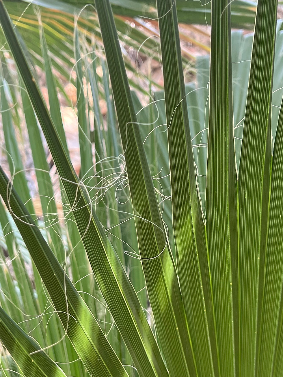
Unlike most desert plants that have adapted to survive in an environment where water is scarce and valuable, desert fan palms disregard water conservation practices. Sporting huge fan-shaped green leaves that transpire water vapor back into the air as if they were living in the wet tropics.
Young California fan palm sprouts are emerging from the sandy, damp soil in the oasis.

Water Seeping from the Fault
They lack the structural or physiological adaptations needed for thriving in a hot and dry climate because desert fan palms are confined to rare desert areas where groundwater is trapped within the fault zone. When an oasis develops under these conditions, it's referred to as a 'seep oasis'.
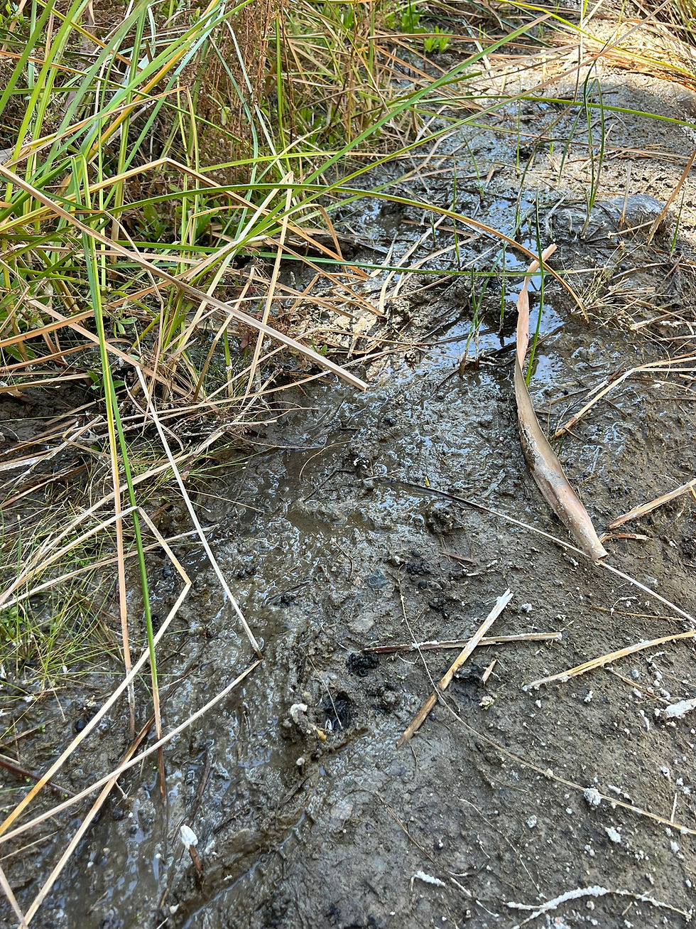
Fault-controlled seeps deposit dissolved minerals from surrounding rocks and soil, creating white salt crusts as desert heat rapidly evaporates the water.

These seeps are vital for the palms' survival. Because Washingtonia filifera relies on high water intake, up to 130 gallons daily in summer, and has shallow, wide-spreading roots, they perish without this abundant, shallow water source.

The only palm native to the western US, these desert giants can reach heights of 60-75 feet and weigh as much as three tons. According to the US Forest Service, palms can live 80-90 years, with some mature specimens living up to 150 years.

Mature palms produce large, hanging clusters of berries, with some stalks weighing up to 20 pounds. The fruit ripens in late summer and early fall, turning from reddish-black to a deep black color. A thin layer of pulp conceals a large seed nearly the same size as the fruit. They have a slightly dry, chewy texture with a mild molasses and butterscotch taste.


The California fan palms naturally keep their dead fronds attached, forming a skirt that drapes down the trunk. These skirts serve as habitat and hazards. Birds, insects, and lizards find a cool shelter among the dead fronds.

Fire and Recovery
In a fire, the same skirts can become ladders for flames. Although the fronds are highly combustible, they burn quickly and cleanly, often charring only the outer trunk without killing the crown.


Here is a picture of the Willis Palms shortly after the 2010 fire (courtesy of Desert Stories). While fronds may regrow, these intense blazes cause immediate fatalities and long-term habitat destruction for wildlife nesting in the skirts, and they can eliminate seedlings, altering the grove’s age structure for years.

After exploring for a considerable amount of time, a faint path on the edge of the oasis led back to the wash.

As we returned to the trail, we kept observing wildlife. A common side-blotched lizard was soaking up the final rays of sunshine on a rock and ...

... a Swainson's hawk soaring overhead.

This desert cottontail, hiding under some mesquite trees, was likely trying to avoid being seen by the hawk.

Closing Thoughts
The 3-hour Willis Palm Loop is a highly recommended, amazing adventure to experience a California palm oasis.

Explore more fault-shaped oases and badlands in the Indio Hills with Pushawalla Palms Oasis Trail and Indio Badlands Trail, where the same tectonic forces create hidden palm groves and sculpted and tortured desert hills.
After the hike, we stayed at the trailhead for a beautiful sunset.

260225


Thank you for the clear and balanced article. The discussion about online entertainment platforms highlights their growing influence in the digital age. For those seeking further details, additional information website. The article provides a well-rounded perspective on this evolving topic.